Area Overview for TN14 5NA
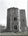
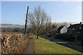
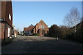
Photos of TN14 5NA


Area Information
Living in TN14 5NA offers a quiet residential experience within a compact cluster of precisely 4581 square metres. This specific postcode covers a population of 1564 people, creating a close-knit community where neighbours know one another. You will find yourself in a setting defined by its density and scale rather than sprawling suburban expansion. The area maintains a population density of 596 people per square kilometre, which suggests local services remain accessible while noise and traffic stay manageable. The environment feels established, with a strong sense of continuity for residents who have called this spot home for decades. Daily life centres on the immediate neighbourhood, far removed from the congestion of larger urban centres. The location serves as a stable base for those seeking stability and peace. It is not a chaotic hub but a settled place where the pace of life moves deliberately. Homeowners dominate the landscape, owning 79% of the local housing stock. This ownership level indicates that money often stays within the community, supporting local businesses and fostering long-term relationships. Whether you are moving here for retirement or seeking a calmer family home, the character of TN14 5NA remains consistent. The area prioritises stability over rapid turnover, creating a predictable and secure environment for anyone looking to settle down.
- Area Type
- Postcode
- Area Size
- 4581 m²
- Population
- 1564
- Population Density
- 596 people/km²
The property market in TN14 5NA is characterised by a distinct lack of private rentals. Full data on property listings and sale prices is not included in the current records, but the structural data tells a clear story. A staggering 79% of households own their own homes, which means the vast majority of housing stock is in owner-occupied hands. This statistic suggests a market driven by people staying in one place for the long term rather than a fluid rental market. The accommodation type is uniformly houses, meaning you will not find flats or apartments in this cluster. If you are looking to buy in TN14 5NA, you are entering a neighbourhood that values permanence. The census-type data indicates that the typical resident is an owner, not a tenant. This structure often leads to better maintained properties, as owners tend to invest more in upkeep than landlords managing portfolio properties. The total area size of 4581 square metres covers this residential cluster, which holds a population of 1564. Such a small footprint ensures that properties are spread within a walkable distance of each other. Buyers seeking single-family homes will find their requirements met here, while those looking for multi-unit developments will find no supply. The high ownership rate implies that properties may change hands less frequently, which can affect liquidity. However, it also signals that buyers are likely committed to the area for generations. The market is one of stability, where the 79% ownership figure rules the landscape.
House Prices in TN14 5NA
Showing 18 properties
| Address | Type | Beds | Baths | Last Sale Price | Last Sale Date | |
|---|---|---|---|---|---|---|
| 6, Shinecroft, Rye Lane, Otford, TN14 5NA | Terraced | 2 | 1 | £389,800 | Jun 2025 | |
| 15, Shinecroft, Rye Lane, Otford, TN14 5NA | Terraced | 2 | 1 | £267,500 | Mar 2024 | |
| 3, Shinecroft, Rye Lane, Otford, TN14 5NA | Terraced | 2 | 1 | £385,000 | May 2020 | |
| 16, Shinecroft, Rye Lane, Otford, TN14 5NA | Terraced | 2 | 1 | £268,000 | Nov 2018 | |
| 8, Shinecroft, Rye Lane, Otford, TN14 5NA | Terraced | 3 | 2 | £385,000 | Aug 2016 | |
| 14, Shinecroft, Rye Lane, Otford, TN14 5NA | Semi-detached | 4 | 2 | £523,500 | Jun 2016 | |
| 10, Shinecroft, Rye Lane, Otford, TN14 5NA | Terraced | 2 | 1 | £305,000 | Dec 2014 | |
| 4, Shinecroft, Rye Lane, Otford, TN14 5NA | Terraced | 2 | 1 | £335,000 | Sep 2014 | |
| 12, Shinecroft, Rye Lane, Otford, TN14 5NA | house | 1 | 1 | £100,000 | Jul 2009 | |
| 5, Shinecroft, Rye Lane, Otford, TN14 5NA | Terraced | - | - | £300,000 | Feb 2007 |
Energy Efficiency in TN14 5NA
Living in TN14 5NA places you within easy reach of essential shopping and transport hubs. Your daily routine benefits from the proximity of five retail locations that cater to practical needs. You can visit Aldi Otford for groceries or head to Sainsburys Sevenoaks for a wider selection of goods. Budgens Kemsing also serves the area, offering convenience stores and bakeries close to home. These five retail outlets provide a solid foundation for weekly shopping without the need for long car journeys. Transport links further enhance your lifestyle, connecting you to five nearby railway stations. Otford Railway Station, Dunton Green Railway Station, and Shoreham Railway Station form a network that extends your reach beyond the local postcode. This rail access offers flexibility for those who prefer trains over cars for their commutes. The area also benefits from a low population density of 596 people per square kilometre, meaning you live in a spacious environment rather than a crowded one. With a total area of just 4581 square metres covering this residential cluster, the setting feels private and contained. While specific parks or leisure centres are not listed in the provided data, the local focus on houses and family ownership suggests a community that supports outdoor activities. The lifestyle here is defined by convenience and quiet, supported by the reliable presence of pubs and shops that serve the 1564 local residents.
Amenities
Schools
| Rank | School | Type | Entry gender | Ages |
|---|
Explore more schools in this area
Go to Schools tabDemographics
The community profile of TN14 5NA reveals an area settled by those in the middle of their lives. The median age stands at 47 years, placing the demographic centre firmly among adults aged between 30 and 64. This age range represents the most common group living in TN14 5NA, indicating a population that is likely established in careers and families rather than teenagers or retirees. The dominance of this age group shapes the local demand for housing and amenities, focusing on practicality and comfort. Home ownership defines the social fabric here, with 79% of residents owning their homes outright or with a mortgage. This high figure contrasts sharply with the private rental sector, suggesting a community built on stability. Accommodation types reflect this picture, as the area consists almost entirely of houses. There is little evidence of high-rise blocks or purpose-built student housing; instead, you look at traditional family dwellings. The predominant ethnic group is White, which aligns with the established nature of the settlement. You will find a homogenous mix of households who have chosen this postcode for its reliability. Deprivation levels are not explicitly measured in the provided data, but the high ownership rate often correlates with financial stability. This demographic profile means the local economy relies heavily on local investment rather than transient rental income.
Household Size
Accommodation Type
Tenure
Ethnic Group
Religion
Household Composition
Age
Household Deprivation
NS-SEC
Explore more demographic insights in this area
Go to Demographics tabPlanning
Planning Constraints
- Flood RiskPremium
- Ramsar Wetland SitesPremium
- Area of Outstanding Natural BeautyPremium
- Protected Nature ReservePremium
- Protected WoodlandPremium