Area Overview for TN14 5DA
Photos of TN14 5DA


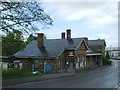
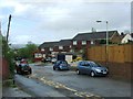

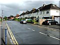
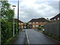
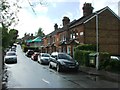
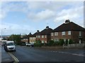

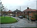
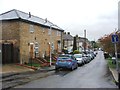
100 photos from this area
Area Information
Key information about the TN14 5DA including its size, population, and administrative classification.
- Area Type
- Postcode
- Area Size
- 9670 m²
- Population
- 1391
- Population Density
- 1430 people/km²
House Prices in TN14 5DA
42
Properties
£269,094
Average Sold Price
£58,250
Lowest Price
£490,000
Highest Price
Showing 42 properties
| Address | Type | Beds | Baths | Last Sale Price | Last Sale Date | |
|---|---|---|---|---|---|---|
| 18 Grove Road, Sevenoaks, TN14 5DA | Terraced | 3 | 1 | £375,000 | Jul 2025 | |
| 29 Grove Road, Sevenoaks, TN14 5DA | Terraced | 2 | 1 | £378,500 | Jul 2023 | |
| 27 Grove Road, Sevenoaks, TN14 5DA | Terraced | 3 | 1 | £415,000 | May 2023 | |
| 39 Grove Road, Sevenoaks, TN14 5DA | Terraced | 2 | 1 | £490,000 | Sep 2022 | |
| 25 Grove Road, Sevenoaks, TN14 5DA | house | - | - | £400,000 | Aug 2022 | |
| 23 Grove Road, Sevenoaks, TN14 5DA | house | 2 | 1 | £365,000 | Jun 2021 | |
| 12 Grove Road, Sevenoaks, TN14 5DA | Terraced | 2 | 1 | £360,000 | Jan 2018 | |
| 11 Grove Road, Sevenoaks, TN14 5DA | house | 3 | - | £317,500 | Nov 2015 | |
| 37 Grove Road, Sevenoaks, TN14 5DA | Terraced | 2 | 1 | £245,000 | Jun 2014 | |
| 13 Grove Road, Sevenoaks, TN14 5DA | Terraced | 2 | 1 | £245,000 | Mar 2012 |
Page 1 of 5
Energy Efficiency in TN14 5DA
Amenities
Schools
| Rank | School | Type | Entry gender | Ages |
|---|
Explore more schools in this area
Go to Schools tabDemographics
Household Size
Family (3-5 people)
most common
Accommodation Type
Houses
most common
Tenure
61
majority
Ethnic Group
White
most common
Religion
N/A
most common
Household Composition
N/A
most common
Age
47
median
Adults (30-64 years)
most common
Household Deprivation
N/A
with no deprivation
NS-SEC
35
in Lower managerial occupations
Explore more demographic insights in this area
Go to Demographics tabPlanning
Planning Constraints
- Flood RiskPremium
- Ramsar Wetland SitesPremium
- Area of Outstanding Natural BeautyPremium
- Protected Nature ReservePremium
- Protected WoodlandPremium