Area Overview for Sheppey East Ward
Photos of Sheppey East Ward


Area Information
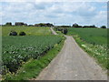
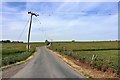
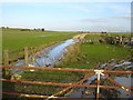
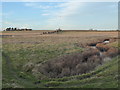
Sheppey East Ward is a distinct district borough unitary ward located on the Isle of Sheppey, an island separated from the Kent mainland by The Swale channel. The communities within this ward, including areas near Minster such as Minster Cliffs East, occupy approximately 56.3 km² of coastal territory. Living in Sheppey East Ward means residing in a setting with a population of 5,853 residents. This area serves as part of the larger Swale Borough Council, offering a semi-rural coastal experience connected to the rest of England via ferry links. The ward sits at coordinates 51.3867°N, 0.8876°E, placing it directly on the northern coast of Kent. Daily life here revolves around proximity to significant landmarks like Minster Abbey. While the ward operates as a discrete administrative unit, its identity is deeply tied to its island geography and separation from the mainland. You can find this ward listed alongside other Sheppey wards, such as Central West and Central South, within the郡's broader electoral map. The physical layout of the island demands specific consideration for travel, yet the area maintains its own character as a defined local neighbourhood.
- Area Type
- District Borough Unitary Ward
- Area Size
- 56.3 km²
- Population
- 5853
- Population Density
- 2461 people/km²
Demographics
The community in Sheppey East Ward reflects a mature demographic profile with a median age of 70 years. This statistic indicates an older population majority compared to many urban centres in South East England. Residents here are drawn from various polling districts, including Mus, which together form the total household composition for the ward. Home ownership is the dominant tenure type, with 71% of households owning their property outright or with a mortgage. This high rate of ownership suggests a settled demographic that values long-term investment in their local homes. The remaining 29% of households likely navigate the rental market or other forms of occupancy. The data does not specify predominant ethnic groups or religious affiliations, though the overall diversity statistics for the area are recorded as totals. Age remains the most significant defining factor in the social structure of Sheppey East Ward. This age distribution influences local services and community engagement, creating a demographic environment shaped largely by retirees and older families.
Household Size
Accommodation Type
Tenure
Ethnic Group
Religion
Household Composition
Age
Household Deprivation
NS-SEC
Explore more demographic insights in this area
Go to Demographics tabPlanning
Planning Constraints
- Flood RiskPremium
- Ramsar Wetland SitesPremium
- Area of Outstanding Natural BeautyPremium
- Protected Nature ReservePremium
- Protected WoodlandPremium
- Crime RiskPremium