Area Overview for RH15 9DJ
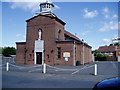
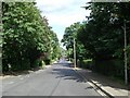
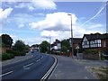
Photos of RH15 9DJ
Area Information
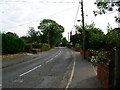
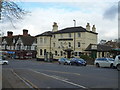
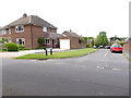
RH15 9DJ represents a specific residential cluster within West Sussex, defined by its compact nature and a population of 1,773 residents. This postcode serves as a tightly knit neighbourhood rather than a sprawling district, making it distinct from larger adjacent settlements. Daily life here revolves around the immediate community boundaries, where proximity to neighbours often fosters a close-knit environment. The area functions as a practical base for its inhabitants, balancing local access with nearby transport links. For anyone considering living in RH15 9DJ, the experience is characterised by a small-scale residential feel rather than urban density. The cluster's limited size means that services and amenities require short trips, yet the overall setup supports standard suburban living. Residents enjoy a settled atmosphere without the congestion found in larger towns. The identity of this area is rooted in its residential status, providing a quiet backdrop for families and individuals seeking a defined place within the broader Burgess Hill locality. Understanding the specific scope of RH15 9DJ helps buyers grasp the true scale of their potential home and the immediate social environment they will join.
- Area Type
- Postcode
- Area Size
- Not available
- Population
- 1773
- Population Density
- 4826 people/km²
The property market in RH15 9DJ is defined by a housing stock where flats represent the primary accommodation type. This distribution contrasts with areas dominated by detached or semi-detached houses, suggesting a design focused on density within a small footprint. With 47% home ownership, roughly half of the residents possess an ownership stake in their property, while the balance resides in the rental sector. This split indicates a balanced market where both owner-occupiers and tenants coexist, though the prevalence of flats often points towards a mix of individual ownership and buy-to-let investments. Buyers looking at this area must consider that they are entering a market shaped by vertical living rather than traditional bungalows or large estates. The small resident population of 1,773 people implies a limited inventory compared to larger towns, which can affect choice and competition. Understanding the flat-centric nature of RH15 9DJ is crucial for assessing suitability, particularly for those seeking ground-floor access or communal facilities versus private gardens. The ownership percentage also reflects the financial investment levels typical within this specific West Sussex cluster.
House Prices in RH15 9DJ
No properties found in this postcode.
Energy Efficiency in RH15 9DJ
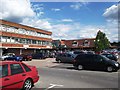
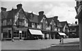
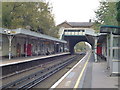
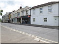
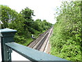
Living in RH15 9DJ places residents within practical reach of essential amenities and rail links. Transport infrastructure is well-served, with five railway stations accessible to the area, including Burgess Hill Railway Station, Wivelsfield Railway Station, and Hassocks Railway Station. This railway connectivity facilitates easy commutes to Brighton and London, integrating the local cluster into the wider national transport network. Retail options are equally convenient, with five notable shopping locations nearby. Residents can visit Waitrose Burgess for quality groceries, Iceland Church for essential household items, or The Southern Co-operative Co-op for local community services. These venues provide everything from fresh produce to everyday necessities without requiring long journeys. The proximity of these specific stores means that daily errands are quick and convenient. The ability to access major supermarkets and a network of trains creates a balanced lifestyle that combines the convenience of town centres with the quiet of residential living. Anyone considering homes in RH15 9DJ will find that their daily needs are met by these specific, nearby facilities efficiently.
Amenities
Schools
| Rank | School | Type | Entry gender | Ages |
|---|
Explore more schools in this area
Go to Schools tabDemographics
The community in RH15 9DJ is dominated by adults aged between 30 and 64 years, reflecting a stable, established population profile. The median age sits at 47 years, indicating that households here are typically composed of those with significant life experience rather than young families or retirees. This age distribution suggests a demand for larger properties or homes adapted for mature living needs. Regarding housing tenure, 47% of residents own their homes outright or with a mortgage, while the remaining portion likely rents their accommodation. The predominant form of accommodation consists of flats, which aligns with the area's classification as a small residential cluster suitable for multi-unit housing. The ethnic composition is primarily White, mirroring the broader demographic trends of many parts of West Sussex. These figures paint a picture of a mature neighbourhood where long-term residency is common. The high concentration of adults in working age brackets implies a community with strong local ties and stability. Prospective buyers should note that the flat-heavy stock and ownership split define the social fabric of this particular postcode sector.
Household Size
Accommodation Type
Tenure
Ethnic Group
Religion
Household Composition
Age
Household Deprivation
NS-SEC
Explore more demographic insights in this area
Go to Demographics tabPlanning
Planning Constraints
- Flood RiskPremium
- Ramsar Wetland SitesPremium
- Area of Outstanding Natural BeautyPremium
- Protected Nature ReservePremium
- Protected WoodlandPremium