Area Overview for RH14 0BE
Photos of RH14 0BE
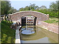
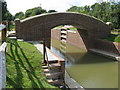
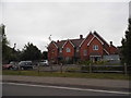
![Wey & Arun Canal - Loxwood [New] Lock in RH14 0BE](https://images.propbar.co.uk/images/geograph/81/59/8159364_120.jpg)
75 photos from this area
Area Information
Key information about the RH14 0BE including its size, population, and administrative classification.
- Area Type
- Postcode
- Area Size
- 7.4 hectares
- Population
- 1974
- Population Density
- 106 people/km²
House Prices in RH14 0BE
21
Properties
£460,371
Average Sold Price
£295,000
Lowest Price
£600,000
Highest Price
Showing 21 properties
| Address | Type | Beds | Baths | Last Sale Price | Last Sale Date | |
|---|---|---|---|---|---|---|
| 5 Hall Hurst Close, Loxwood, RH14 0BE | Semi-detached | 3 | 2 | £415,000 | Jun 2021 | |
| 16 Hall Hurst Close, Loxwood, RH14 0BE | house | - | - | £410,000 | Apr 2021 | |
| Tan Y Coed, 12 Hall Hurst Close, Loxwood, RH14 0BE | house | - | - | £484,500 | Feb 2021 | |
| 10 Hall Hurst Close, Loxwood, RH14 0BE | house | - | - | £458,000 | Feb 2021 | |
| 14 Hall Hurst Close, Loxwood, RH14 0BE | Detached | 3 | 2 | £460,000 | Jul 2017 | |
| 18 Hall Hurst Close, Loxwood, RH14 0BE | Detached | 4 | - | £599,950 | Oct 2015 | |
| 7 Hall Hurst Close, Loxwood, RH14 0BE | house | - | - | £557,000 | Oct 2010 | |
| 11 Hall Hurst Close, Loxwood, RH14 0BE | house | - | - | £340,000 | Jun 2010 | |
| 9 Hall Hurst Close, Loxwood, RH14 0BE | house | - | - | £600,000 | Jun 2010 | |
| 8 Hall Hurst Close, Loxwood, RH14 0BE | house | - | - | £595,000 | May 2010 |
Page 1 of 3
Energy Efficiency in RH14 0BE
Amenities
Schools
| Rank | School | Type | Entry gender | Ages |
|---|
Explore more schools in this area
Go to Schools tabDemographics
Household Size
Two person
most common
Accommodation Type
Houses
most common
Tenure
83
majority
Ethnic Group
White
most common
Religion
N/A
most common
Household Composition
N/A
most common
Age
47
median
Adults (30-64 years)
most common
Household Deprivation
N/A
with no deprivation
NS-SEC
46
in Lower managerial occupations
Explore more demographic insights in this area
Go to Demographics tabPlanning
Planning Constraints
- Flood RiskPremium
- Ramsar Wetland SitesPremium
- Area of Outstanding Natural BeautyPremium
- Protected Nature ReservePremium
- Protected WoodlandPremium