Area Overview for RH10 4LD
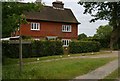
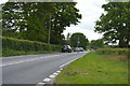
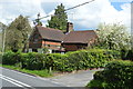
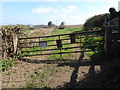
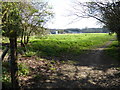
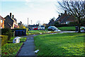
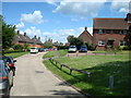
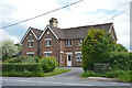
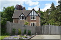
Photos of RH10 4LD
Area Information
Living in RH10 4LD offers a quiet residential experience within a defined cluster of homes. This postcode covers an area of 12.2 hectares, creating a compact but self-contained community. You will find 1,932 residents calling this small space home, resulting in a population density of 364 people per square kilometre. The location functions as a distinct pocket of housing rather than a sprawling suburb. Its size and structure suggest a neighbourhood where residents know one another, fostering a close-knit atmosphere. Daily life here revolves around the immediate surroundings and access to points just beyond the postcode boundary. The area provides a settled environment for families and individuals seeking a balance between home life and local convenience. You do not deal with the chaos of large urban centres while retaining essential services nearby. This specific residential cluster delivers stability and calm. The layout supports a predictable routine where the walk to local shops or the bus stop defines your week.
- Area Type
- Postcode
- Area Size
- 12.2 hectares
- Population
- 1932
- Population Density
- 364 people/km²
The property market in RH10 4LD is characterised by a strong preference for ownership. With 82% of the population owning their homes, this area functions primarily as a market for established buyers rather than a hub for young professionals renting their first property. Houses comprise the main accommodation type, meaning you can expect to find detached or semi-detached properties rather than flats or apartments. This ownership structure implies that the local housing stock is designed for long-term living and contentment. The small size of the postcode cluster means the total number of homes is limited, which can make finding specific properties competitive if demand rises for this type of residence. The environment suits those seeking a conventional English home with its own garden or driveway. You will find fewer shared ownership schemes or purpose-built rental blocks here. The market reflects a desire for stability and control over one's living space. If you are a first-time buyer, this area might require access to mortgage financing for purchase rather than a deposit-free rent option.
House Prices in RH10 4LD
Showing 15 properties
| Address | Type | Beds | Baths | Last Sale Price | Last Sale Date | |
|---|---|---|---|---|---|---|
| Thyme Cottage, Sandhill Lane, Crawley Down, RH10 4LD | Detached | 6 | 4 | £1,195,880 | Nov 2023 | |
| The Loklamp, Sandhill Lane, Crawley Down, RH10 4LD | Detached | 3 | 2 | £570,000 | Jul 2023 | |
| Sideways, Sandhill Lane, Crawley Down, RH10 4LD | Bungalow | - | - | £875,000 | Jan 2022 | |
| Green Hedges, Sandhill Lane, Crawley Down, RH10 4LD | house | - | - | £1,022,000 | Feb 2021 | |
| Holly House, Sandhill Lane, Crawley Down, RH10 4LD | Semi-detached | 4 | 2 | £820,000 | Nov 2018 | |
| Chestnut House, Sandhill Lane, Crawley Down, RH10 4LD | Detached | 5 | 3 | £775,000 | Oct 2014 | |
| Holly Cottage, Sandhill Lane, Crawley Down, RH10 4LD | Semi-detached | 4 | 2 | £390,000 | Nov 2008 | |
| Sandhill House, Sandhill Lane, Crawley Down, RH10 4LD | Detached | 7 | 5 | - | - | |
| Wedza, Sandhill Lane, Crawley Down, RH10 4LD | Detached | 3 | 2 | - | - | |
| April Cottage, Sandhill Lane, Crawley Down, RH10 4LD | Flat | - | - | - | - |
Energy Efficiency in RH10 4LD
Your everyday life in RH10 4LD is supported by a practical network of amenities located within practical reach. For shopping needs, you have five retail options nearby, including Morrisons Daily Crawley, Co-op Crawley, and Asda Copthorne. These stores allow you to collect essentials without the need to travel far into Crawley town centre. Public transport provides four metro stations in the vicinity, such as Kingscote and the Gatwick South Terminal Shuttle Station, offering direct links to the airport. Five railway stations serve the area, including East Grinstead, Three Bridges, and Dormans, giving you access to London and other major towns. For scheduled travel, the South Terminal Coach Station is just a short distance away, facilitating trips to Brighton or other southern destinations. The presence of London Gatwick Airport nearby means business travel is conceivable from this location. You do not need your car for standard weekly runs or regional trips. The variety of venues ensures that shopping, commuting, and leisure can be managed efficiently from this postcode.
Amenities
Schools
| Rank | School | Type | Entry gender | Ages |
|---|
Explore more schools in this area
Go to Schools tabDemographics
The community in RH10 4LD is established and mature, reflecting the fact that 82% of residents own their homes. This high level of ownership indicates stability and long-term roots among the population. Houses form the predominant accommodation type, fitting the profile of a family-oriented or settled neighbourhood. The demographic data shows a median age of 47 years, with adults between the ages of 30 and 64 representing the most common age range. This suggests a neighbourhood dominated by middle-aged professionals and older workers rather than young students or young families just starting out. The predominant ethnic group listed is White, shaping the cultural fabric of the village. You navigate a community where many households have stayed put for decades. This maturity brings a sense of permanence to the estate. The housing stock generally caters to those who have moved past the transient phase of early adulthood. Buyers looking for this demographic profile will find the environment matches their expectations of a settled, owner-occupied locality.
Household Size
Accommodation Type
Tenure
Ethnic Group
Religion
Household Composition
Age
Household Deprivation
NS-SEC
Explore more demographic insights in this area
Go to Demographics tabPlanning
Planning Constraints
- Flood RiskPremium
- Ramsar Wetland SitesPremium
- Area of Outstanding Natural BeautyPremium
- Protected Nature ReservePremium
- Protected WoodlandPremium