Area Overview for RG8 0JS
Photos of RG8 0JS
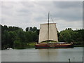

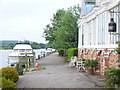
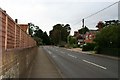
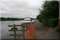

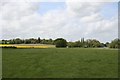
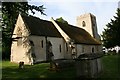
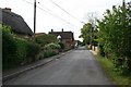
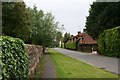
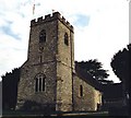
100 photos from this area
Area Information
Key information about the RG8 0JS including its size, population, and administrative classification.
- Area Type
- Postcode
- Area Size
- 37.6 hectares
- Population
- 1665
- Population Density
- 177 people/km²
House Prices in RG8 0JS
39
Properties
£708,889
Average Sold Price
£62,000
Lowest Price
£1,770,000
Highest Price
Showing 39 properties
| Address | Type | Beds | Baths | Last Sale Price | Last Sale Date | |
|---|---|---|---|---|---|---|
| Jyms Cottage, The Street, South Stoke, Reading, RG8 0JS | Detached | 3 | 2 | £800,000 | May 2025 | |
| Plumtree Cottage, The Street, South Stoke, Reading, RG8 0JS | Detached | 3 | 2 | £623,000 | Feb 2021 | |
| White House, The Street, South Stoke, Reading, RG8 0JS | Detached | 2 | 1 | £745,000 | Aug 2020 | |
| Herons, The Street, South Stoke, Reading, RG8 0JS | Detached | 4 | 3 | £975,000 | Jun 2019 | |
| The Ryepeck, The Street, South Stoke, Reading, RG8 0JS | Detached | 5 | 2 | £62,000 | May 2016 | |
| Dove Tree Cottage, The Street, South Stoke, Reading, RG8 0JS | Detached | 5 | 1 | £1,200,000 | May 2016 | |
| Frewins Close, The Street, South Stoke, Reading, RG8 0JS | Detached | 5 | - | £1,770,000 | Aug 2015 | |
| Church View, The Street, South Stoke, Reading, RG8 0JS | Detached | 4 | 2 | £860,000 | Apr 2014 | |
| Tudor Cottage, The Street, South Stoke, Reading, RG8 0JS | Detached | 3 | 1 | £585,000 | Dec 2012 | |
| Ebony Barn, The Street, South Stoke, Reading, RG8 0JS | Detached | 4 | 3 | £480,000 | Sep 2006 |
Page 1 of 4
Energy Efficiency in RG8 0JS
Amenities
Schools
| Rank | School | Type | Entry gender | Ages |
|---|
Explore more schools in this area
Go to Schools tabDemographics
Household Size
Two person
most common
Accommodation Type
Houses
most common
Tenure
72
majority
Ethnic Group
White
most common
Religion
N/A
most common
Household Composition
N/A
most common
Age
47
median
Adults (30-64 years)
most common
Household Deprivation
N/A
with no deprivation
NS-SEC
52
in Lower managerial occupations
Explore more demographic insights in this area
Go to Demographics tabPlanning
Planning Constraints
- Flood RiskPremium
- Ramsar Wetland SitesPremium
- Area of Outstanding Natural BeautyPremium
- Protected Nature ReservePremium
- Protected WoodlandPremium