Area Overview for RG5 4WL
Photos of RG5 4WL
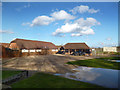
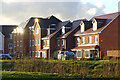
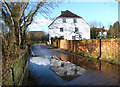
7 photos from this area
Area Information
Key information about the RG5 4WL including its size, population, and administrative classification.
- Area Type
- Postcode
- Area Size
- 2.1 hectares
- Population
- 2748
- Population Density
- 3223 people/km²
House Prices in RG5 4WL
69
Properties
£329,227
Average Sold Price
£46,200
Lowest Price
£585,000
Highest Price
Showing 69 properties
| Address | Type | Beds | Baths | Last Sale Price | Last Sale Date | |
|---|---|---|---|---|---|---|
| 15 Clover Rise, Woodley, RG5 4WL | Flat | 2 | 2 | £247,000 | Oct 2025 | |
| 50 Clover Rise, Woodley, RG5 4WL | Semi-detached | 4 | 1 | £535,000 | Mar 2025 | |
| 58 Clover Rise, Woodley, RG5 4WL | Maisonette | 2 | 1 | £271,000 | Nov 2024 | |
| 64 Clover Rise, Woodley, RG5 4WL | Flat | - | - | £248,500 | May 2023 | |
| 54 Clover Rise, Woodley, RG5 4WL | Flat | - | - | £46,200 | Apr 2023 | |
| 66 Clover Rise, Woodley, RG5 4WL | Flat | - | - | £266,500 | Aug 2022 | |
| 5 Clover Rise, Woodley, RG5 4WL | Flat | 3 | 2 | £270,000 | Aug 2022 | |
| 22 Clover Rise, Woodley, RG5 4WL | Terraced | 3 | 3 | £435,000 | Apr 2022 | |
| 60 Clover Rise, Woodley, RG5 4WL | Maisonette | 1 | - | £215,000 | Sep 2021 | |
| 33 Clover Rise, Woodley, RG5 4WL | Semi-detached | 4 | 3 | £455,000 | Sep 2021 |
Page 1 of 7
Energy Efficiency in RG5 4WL
Amenities
Schools
| Rank | School | Type | Entry gender | Ages |
|---|
Explore more schools in this area
Go to Schools tabDemographics
Household Size
Family (3-5 people)
most common
Accommodation Type
Houses
most common
Tenure
81
majority
Ethnic Group
White
most common
Religion
N/A
most common
Household Composition
N/A
most common
Age
47
median
Adults (30-64 years)
most common
Household Deprivation
N/A
with no deprivation
NS-SEC
55
in Lower managerial occupations
Explore more demographic insights in this area
Go to Demographics tabPlanning
Planning Constraints
- Flood RiskPremium
- Ramsar Wetland SitesPremium
- Area of Outstanding Natural BeautyPremium
- Protected Nature ReservePremium
- Protected WoodlandPremium