Area Overview for RG40 3BH
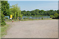
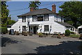
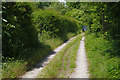
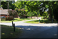
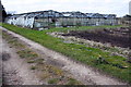
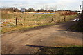
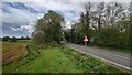
Photos of RG40 3BH

Area Information
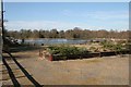
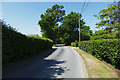
Living in RG40 3BH offers a defined residential experience within a small cluster rather than a sprawling district. The postcode covers approximately 1,642 people across the country of England, creating a tight-knit environment with a population density of 220 people per square kilometre. This density suggests a neighbourhood where residents know one another, yet the area remains distinct as a specific residential unit rather than a large town. Daily life here revolves around the quiet practicalities of private living, detached from the constant pace of larger urban centres. The area functions as a stable home base for those who prioritise security and space over bustling street life. You will find the rhythm of life is dictated by the quality of your immediate surroundings rather than distant metropolitan trends. The character of RG40 3BH is defined by its concentration of households in a manageable footprint. This setting appeals to individuals seeking a predictable environment where the local amenity network is within easy reach. The area does not try to emulate larger cities but stands firmly on its own merits as a settled community. Whether you commute to the wider region or focus on local necessities, the layout supports a straightforward daily routine without unnecessary complexity or congestion.
- Area Type
- Postcode
- Area Size
- Not available
- Population
- 1642
- Population Density
- 220 people/km²
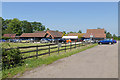
The property market in RG40 3BH is characterised by a strong leaning towards owner-occupied homes. With 63% of residents owning their homes entirely, this postcode functions more as a settled market than a rental hub. This statistic indicates that if you purchase a home here, you are entering a community of long-term residents rather than transient tenants. The accommodation type data confirms that houses form the backbone of the stock in this area. This absence of significant apartment blocks means the streetscape is dominated by private residences with dedicated grounds. For buyers looking at homes in RG40 3BH, this structure implies a consistent architectural style and a shared interest in property maintenance. The small residential cluster nature of the postcode means you cannot expect the vast variety found in major urban zones, but you gain the benefit of a uniform housing stock. Prices and values here track with the specific demand for family-sized housing rather than investment flats. The high ownership percentage also means mortgage lenders view this area as a stable location for residential loans. Buyers should focus on the specific condition of each house, as the inventory does not include large-scale private rentals or temporary accommodations.
House Prices in RG40 3BH
Showing 1 properties
| Address | Type | Beds | Baths | Last Sale Price | Last Sale Date | |
|---|---|---|---|---|---|---|
| Heathlands Farm, Honey Hill, Crowthorne, RG40 3BH | Detached | - | - | - | - |
Energy Efficiency in RG40 3BH
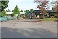
Lifestyle convenience in RG40 3BH is anchored by a cluster of local amenities within practical reach. Residents can visit five retail outlets, including Tesco Crowthorne and Co-op Montaque, which provide essential shopping needs. If you require a larger selection, Tesco Wokingham is also accessible, offering a wider range of groceries and household goods. Transport links are robust with five railway stations nearby, starting with Crowthorne Railway Station and extending to Wokingham Railway Station and Bracknell Railway Station. These connections allow you to travel to major cities without dealing with car dependency. You can also fly privately or commercially via Blackbushe Airport, located just one station away in the network. This proximity to aviation facilities adds a unique layer of convenience for business travellers or those requiring urgent logistics. The combination of comprehensive retail, multiple rail hubs, and airport access creates a self-supporting utility network. Daily life involves a short walk or a brief train ride to complete almost any personal errand. This variety of options means you can keep most activities local while retaining rapid access to the wider region when needed.
Amenities
Schools
Families living in RG40 3BH have access to a mix of state and private education options within practical reach. The nearest primary education is provided by Saint Sebastian's Church of England Aided Primary School, which serves the local infant community. You can also find Saint Sebastians Church of England Primary School, offering similar foundational learning for younger children. Beyond the state sector, the area provides independent education through Ludgrove School Trust Limited and Holme Grange School. This combination of state and independent institutions gives parents a choice of educational philosophy and curriculum. Saint Sebastian's Church of England Aided Primary School focuses on religious and community values in its lessons, while the nearby independent schools often offer broader boarding or day options with specialized facilities. The presence of multiple primaries means parental choice is available even within this specific cluster. However, families must plan carefully, as these schools serve specific catchment areas or charge tuition fees depending on their type. The mix of institutions indicates a neighbourhood that accommodates both faith-based and secular educational preferences. Quality of life for child-rearing in RG40 3BH is supported by this accessible network of established educational providers nearby.
| Rank | School | Type | Entry gender | Ages |
|---|
Explore more schools in this area
Go to Schools tabDemographics
The community in RG40 3BH reflects a settled population with a median age of 47 years. Most commonly, the residents fall into the adult age range between 30 and 64 years, indicating a neighbourhood dominated by working families and established households. This demographic profile suggests a stable environment where long-term residents outnumber transient occupants. Home ownership stands at 63%, a figure that confirms the majority of people here have purchased their properties rather than renting. This rate points towards a community of people invested in their location with a desire for stability. The predominant ethnic group is White, which aligns with the broader demographic trends of many established residential clusters in the region. Accommodation types are primarily houses, meaning you are likely to find detached or semi-detached properties rather than high-rise apartments or terraced housing. This mix supports a lifestyle that privileges yards and private outdoor space. The lower housing density combined with a high ownership rate creates an atmosphere where residents have a strong stake in the upkeep and appearance of their streets. Demographics drive the local culture, and this area reflects the preferences of a mature population seeking comfort and permanence.
Household Size
Accommodation Type
Tenure
Ethnic Group
Religion
Household Composition
Age
Household Deprivation
NS-SEC
Explore more demographic insights in this area
Go to Demographics tabPlanning
Planning Constraints
- Flood RiskPremium
- Ramsar Wetland SitesPremium
- Area of Outstanding Natural BeautyPremium
- Protected Nature ReservePremium
- Protected WoodlandPremium