Area Overview for RG22 4JY
Photos of RG22 4JY

Area Information
RG22 4JY occupies a compact footprint of 3.1 hectares, housing a community of 1,458 people in England. The density here is substantial at 47,208 people per square kilometre, indicating a tightly knit residential cluster rather than sprawling development. This postcode represents a specific pocket where daily life revolves around close proximity to neighbours and immediate access to local infrastructure. Residents navigate a neighbourhood defined by its efficiency and established character. The area is not a vast district but a defined cluster where services and homes exist within easy reach. Living in RG22 4JY means dealing with a mature environment where space is shared efficiently among a significant population. The physical size limits the scope for new large-scale construction but ensures that amenities remain close at hand. You walk through streets populated by individuals from the dominant age group of adults between 30 and 64 years. The environment is structured around the practicalities of suburban living, balancing residential comfort with urban convenience. There is no ambiguity about the scale; it is a small, dense area designed for settled living. Your routine involves moving quickly between your home, local retail outlets, and transport links. The character of RG22 4JY is one of function, where every hectare serves a purpose within the wider Basingstoke catchment.
- Area Type
- Postcode
- Area Size
- 3.1 hectares
- Population
- 1458
- Population Density
- 6813 people/km²
Houses dominate the housing stock within RG22 4JY, making this postcode a primarily residential zone rather than a mix of flats or multi-unit developments. With 42 per cent of homes owned outright, the market features a secondary subset of owner-occupiers alongside a large rental population. This split indicates a diverse appeal where both those seeking roots and those seeking flexibility find suitable homes in this 3.1 hectare area. Buyers looking for houses rather than apartments will find the natural fit for their requirements here. The accommodation type is uniform, avoiding the complexity of mixed-use estates where amenities are solely built for residents. The high population density relative to the small land area suggests a housing environment where plots may be closer together than in rural RG22 locations, creating a more village-like atmosphere despite the suburban designation. Selling a property in RG22 4JY involves engaging with a market where you compete against other houses rather than unique units. For investors or owners entering the market, the 42 per cent ownership figure serves as a baseline for tenant quality and retention. The lack of flat construction means you do not need to adjust expectations for smaller units designed for singles. The market reflects a clear preference for traditional house living, catering to families and individual buyers who value space and garden access.
House Prices in RG22 4JY
Showing 67 properties
| Address | Type | Beds | Baths | Last Sale Price | Last Sale Date | |
|---|---|---|---|---|---|---|
| 23 Boyce Close, Basingstoke, RG22 4JY | Terraced | 3 | 1 | £315,000 | Sep 2025 | |
| 49 Boyce Close, Basingstoke, RG22 4JY | Terraced | 3 | 1 | £315,000 | Jul 2025 | |
| 38 Boyce Close, Basingstoke, RG22 4JY | Terraced | 3 | 1 | £316,000 | Feb 2025 | |
| 3 Boyce Close, Basingstoke, RG22 4JY | Terraced | 3 | 1 | £325,000 | Aug 2024 | |
| 43 Boyce Close, Basingstoke, RG22 4JY | Terraced | 4 | 3 | £420,000 | May 2023 | |
| 24 Boyce Close, Basingstoke, RG22 4JY | house | 3 | 1 | £305,000 | Nov 2022 | |
| 13 Boyce Close, Basingstoke, RG22 4JY | Terraced | 3 | 1 | £335,000 | Oct 2022 | |
| 29 Boyce Close, Basingstoke, RG22 4JY | Terraced | 3 | 1 | £310,000 | Sep 2022 | |
| 45 Boyce Close, Basingstoke, RG22 4JY | Retail | 3 | 1 | £278,000 | Mar 2022 | |
| 65 Boyce Close, Basingstoke, RG22 4JY | Maisonette | 2 | 1 | £166,500 | Dec 2021 |
Energy Efficiency in RG22 4JY
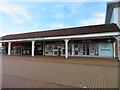
Residents of RG22 4JY have access to a practical range of retail and transport options within practical reach. Three major supermarkets define the shopping landscape: Asda Basingstoke, Morrisons Daily Basingstoke Buckland PDE, and Tesco Kempshott. These venues provide comprehensive groceries and daily essentials without requiring long drives. For rail transport, two stations serve the immediate vicinity: Basingstoke Railway Station and Overton Railway Station. These links offer direct connections to London and the wider network, facilitating easy commutes for residents. Leisure travel is also convenient, with Lasham Airport located nearby for private aviation needs. The combination of these amenities creates a lifestyle where you do not need to venture far for goods or transit. Daily errands conclude quickly, allowing you more time for family or leisure activities. The shopping options cater to varied household budgets and requirements through different store formats. You can plan your weekly shop at Asda or pick up items at a Tesco Express nearby. The presence of multiple stations gives you choices depending on your specific journey requirements or schedule. This amenity density underpins the convenience of living in such a densely populated zone.
Amenities
Schools
| Rank | School | Type | Entry gender | Ages |
|---|
Explore more schools in this area
Go to Schools tabDemographics
The community profile of RG22 4JY reflects a mature population with a median age of 47 years. Adults aged between 30 and 64 years form the most common age range in this neighbourhood. This demographic structure suggests an area favoured by those stabilising later in life or in their career. Home ownership stands at 42 per cent, meaning the majority of residents are in the tenure of renting their properties. Houses remain the predominant accommodation type across this postcode, aligning with the general desire for space in established locations. The predominant ethnic group within RG22 4JY is White, contributing to a specific regional cultural character. With over four out of five households renting, the local rental market is robust and active. The age spread indicates a settled community rather than one dominated by families with very young children or elderly retirees living in care facilities. You are joining an area where the primary occupants are working adults managing family or professional responsibilities. The 42 per cent ownership rate contrasts with higher ownership found in rural villages, suggesting this location appeals to those seeking flexibility or proximity to employment centres. The demographic data paints a picture of stability, defined by a lack of very young families and a strong presence of middle-aged homeowners and renters alike.
Household Size
Accommodation Type
Tenure
Ethnic Group
Religion
Household Composition
Age
Household Deprivation
NS-SEC
Explore more demographic insights in this area
Go to Demographics tabPlanning
Planning Constraints
- Flood RiskPremium
- Ramsar Wetland SitesPremium
- Area of Outstanding Natural BeautyPremium
- Protected Nature ReservePremium
- Protected WoodlandPremium