Area Overview for Queenborough and Halfway Ward
Photos of Queenborough and Halfway Ward
Area Information
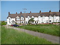
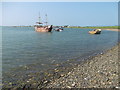
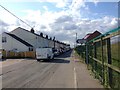
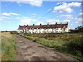
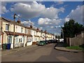
Queenborough and Halfway Ward covers an area of 16.8 km² in the heart of Kent. Living here means accepting a very specific residential profile. The median age is 70, which defines the daily rhythm of the town. Daily life revolves around a mature population rather than young professionals or families with school-age children. This demographic skew portrays a traditional settlement where residents have put down deep roots. The area feels established and quiet. You will not find the noise or density associated with major commuter hubs. Instead, you encounter a community built over decades of occupation. The space is constrained by its small footprint, yet it accommodates a significant level of permanent residence. This ward is distinct from neighbouring districts due to its extreme age profile. It serves as a dedicated space for older generations. While the lack of younger demographics may limit certain types of nightlife or family services, the stability of the community is evident. Houses in Queenborough and Halfway Ward remain in the hands of their original occupants for extended periods. The environment reflects a history of permanence rather than rapid turnover.
- Area Type
- District Borough Unitary Ward
- Area Size
- 16.8 km²
- Population
- Not available
- Population Density
- Not available
Demographics
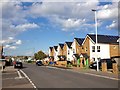
The community in Queenborough and Halfway Ward is defined by a singular statistic: the median age is 70. This figure alone tells you that the population is predominantly elderly. Most residents fall into the older age brackets. You are dealing with a cohort that has likely retired to the county or chosen this location for its close-knit nature. Household data confirms this pattern. With 70% home ownership, the majority of these older residents own their flats or houses. This high rate of equity suggests financial security among the local population. Only 30% of households rent, which is a relatively low proportion compared to younger urban areas. The distribution of accommodation types aligns with this ownership profile, featuring a mix of terraced houses and older flats. The area lacks significant ethnic or religious diversity markers in the available data, pointing toward a homogeneous, likely historically British, community. There is no indication of a transient workforce. The population is stable. Deprivation is not highlighted in the provided figures, but the high ownership rate generally correlates with lower economic pressure on the majority of residents. You are looking at a settled, affluent demographic regarding their housing security. The social fabric appears tight, centred on long-term tenure rather than short-term renting.
Household Size
Accommodation Type
Tenure
Ethnic Group
Religion
Household Composition
Age
Household Deprivation
NS-SEC
Explore more demographic insights in this area
Go to Demographics tabPlanning
Planning Constraints
- Flood RiskPremium
- Ramsar Wetland SitesPremium
- Area of Outstanding Natural BeautyPremium
- Protected Nature ReservePremium
- Protected WoodlandPremium
- Crime RiskPremium