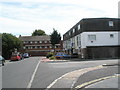
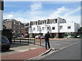
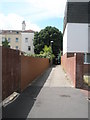
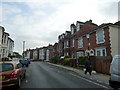
Area Overview for PO5 4NR
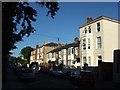
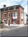
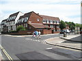
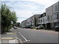
Photos of PO5 4NR


Area Information
Living in PO5 4NR means residing in a specific residential cluster defined by the postcode area, located within England. With a population of 1,753, this small geographic footprint offers a contained living environment distinct from the broader Portsmouth postcodes you may know. The location functions primarily as a housing zone rather than a commercial or industrial hub. Residents here experience daily life within a tightly defined neighbourhood where local services and amenities are within practical reach. As a resident, you would find the area defined by its density and focus on accommodation rather than expansive green space or large-scale infrastructure. The community is characterised by high-rise living, which shapes the visual character of the streets and the sense of neighbourhood from a distance. For anyone seeking homes in PO5 4NR, the reality is a self-contained pocket of urban density situated in a larger city context. This area serves as a specific address for those prioritising proximity to central transport links or major railway stations nearby.
- Area Type
- Postcode
- Area Size
- Not available
- Population
- 1753
- Population Density
- 11845 people/km²
The property market in PO5 4NR is defined almost entirely by rental living due to a home ownership percentage of just 8%. This statistic indicates that the successful history of this cluster is built upon a foundation of tenanted flats rather than owner-occupied properties. You will find that the housing stock consists predominantly of flats, a fact that dictates the typical design, layout, and amenities available to buyers or renters. When searching for homes in PO5 4NR, you are looking at a specific segment of the market focused on accommodation within these low owner-occupancy rates. This area does not offer the traditional suburban house-buying experience. Instead, the market reflects a high-density urban model where the average resident has a lease or tenancy agreement rather than freehold title. The low rate of homeownership suggests thatNoise barriers, maintenance responsibilities, and local association rules are more relevant concerns for residents here than garden maintenance or driveway paving. Potential investors or renters should view PO5 4NR as a specialist market for flat living in a specific postcode sector.
House Prices in PO5 4NR
No properties found in this postcode.
Energy Efficiency in PO5 4NR
Residents of PO5 4NR have immediate access to a range of retail and transport amenities within practical reach of their homes. For shopping needs, you can visit Asda Portsmouth, Farmfoods Fratton, or The Southern Co-operative Co, as these represent five notable retailers in the wider immediate vicinity. Transport connectivity is extensive with five railway stations and five ferry terminals listed as accessible points of interest. Fratton Railway Station and Portsmouth & Southsea Railway Station facilitate travel on the train network. Southsea Hoverport offers hovercraft travel options. For those travelling to the Isle of Wight or taking cruises, Portsmouth IOW Car Ferry Terminal, Portsmouth International Cruise & Ferry Terminal, and Portsmouth Millenium Pontoon serve as key departure points. This concentration of travel hubs means PO5 4NR is well-positioned for both local commuting and major national journeys. The presence of multiple supermarkets ensures grocery shopping can be done easily without leaving the city boundary.
Amenities
Schools
Families considering schools near PO5 4NR have access to a specific list of educational institutions within the local catchment area. Froddington Park Infant School serves the younger years in this network. Somersgrove Junior School and Somers Park Primary School provide primary education options for children growing up in the neighbourhood. Ark Ayrton Primary Academy is also located nearby and holds a good Ofsted rating, a verified metric of its educational standard. The mix of these schools indicates a primary-level focus for the surrounding educational landscape. There are no secondary schools listed in the immediate data for this specific cluster, meaning older children in PO5 4NR would likely travel further for high school education. For parents weighing options, the presence of Ark Ayrton Primary Academy with its good rating offers a specific point of quality assurance within the primary sector. The variety of primary schools suggests multiple options for different sectors of the primary education circuit.
| Rank | School | Type | Entry gender | Ages |
|---|
Explore more schools in this area
Go to Schools tabDemographics
The community in PO5 4NR presents a clear demographic profile shaped by specific living arrangements. Adults between the ages of 30 and 64 years represent the most common age range within this population. The median age of residents is 47, indicating a demographic skewed towards established adults rather than young families or elderly retirees. Home ownership stands at a low figure of 8%, meaning the vast majority of the 1,753 people living here rent their accommodation. Flats form the predominant accommodation type, reinforcing the high-density nature of the cluster. The predominant ethnic group in this area is White, reflecting the specific social composition of this postcode segment. There is no satellite data provided on deprivation levels, so any analysis of economic hardship or quality of life based on such metrics remains outside the scope of verified information for this specific location. You should expect a community where temporary housing or long-term renting is the standard model rather than family ownership of detached or semi-detached homes.
Household Size
Accommodation Type
Tenure
Ethnic Group
Religion
Household Composition
Age
Household Deprivation
NS-SEC
Explore more demographic insights in this area
Go to Demographics tabPlanning
Planning Constraints
- Flood RiskPremium
- Ramsar Wetland SitesPremium
- Area of Outstanding Natural BeautyPremium
- Protected Nature ReservePremium
- Protected WoodlandPremium