Area Overview for PO4 9NE
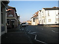
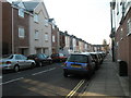
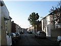
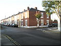
Photos of PO4 9NE


Area Information
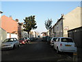
PO4 9NE is a small residential cluster within England, home to a population of 1,435 people. This postcode covers a specific area designed to support a close-knit community rather than a sprawling city centre. You are looking at a neighbourhood defined by its stability and practical connectivity. The locality offers a straightforward environment for those seeking a slice of Portsmouth without the noise of the core urban zones. Living here means you are part of a defined group rather than drifting through a massive municipality. The area sits within the PO4 postcode district, linking residents to the wider South coast infrastructure. There are no hidden surprises in this terrain; it is a genuine residential space where daily routines revolve around established local links. You will find that the community is tightly organised, which often appeals to families or individuals who value order. The location provides direct access to established transport nodes and retail hubs nearby. It is a place where you can build a routine based on known distances rather than guesswork. The character of PO4 9NE is all about functionality and restricted boundaries.
- Area Type
- Postcode
- Area Size
- Not available
- Population
- 1435
- Population Density
- 4115 people/km²
Homes in PO4 9NE remain firmly in the realm of private ownership. With a home ownership rate of 69 per cent, this postcode is not a rental hub. The vast majority of properties are owned outright by their occupants. The accommodation type is exclusively houses; you will not find flats or purpose-built apartments in this specific cluster. This reality shapes the local market entirely around detached, semi-detached, or terraced family homes. Buyers looking at PO4 9NE should expect to engage with landlords who have lived there for years rather than transient tenants. The lack of rental stock removes the volatility often seen in student or high-turnover zones. Every transaction here involves a permanent move rather than a short-term lease flip. The high ownership rate signals low vacancy and steady demand for similar properties nearby. If you are selling a home in this area, you benefit from a buyer base that understands the value of established housing stock. The market is insulated from the fluctuations that plague pure investment districts. You are dealing with a traditional property sector where bricks and mortar hold more value than monthly yields.
House Prices in PO4 9NE
No properties found in this postcode.
Energy Efficiency in PO4 9NE
Daily life in PO4 9NE centres on the retail and transport amenities located just outside the immediate residential boundaries. You have five notable retail options nearby, including the flagship stores of Tesco Cumberland and The Southern Co-operative Co. These supermarkets provide comprehensive weekly shopping without requiring a long daily journey. Fashionable items and household essentials are available at The Southern Co-operative Co, ensuring convenience for householders. Transport choices expand your lifestyle radius significantly with five major ferry and rail sites at your disposal. Venturing to Fratton Railway Station or Portsmouth & Southsea Railway Station gives you access to the rest of the continent via train. Eastney Ferry Landing and Hayling Island Ferry Landing offer leisure trips to nearby islands. The Portsmouth International Cruise & Ferry Terminal connects you to international destinations. Five railway stations in your broader reach mean you can switch between Southsea, Portsmouth, and Fratton effortlessly. Your day-to-day relies on this circle of five shops and five transport terminals. This density of amenities means you rarely need a private car for basic needs. You can walk or take a short drive to loads of shops and then hop on a train immediately after.
Amenities
Schools
| Rank | School | Type | Entry gender | Ages |
|---|
Explore more schools in this area
Go to Schools tabDemographics
The community within this postcode is dominated by adults, with the most common age range falling between 30 and 64 years old. The median age stands at 47, confirming an older demographic than many national averages. Sixty-nine per cent of residents own their homes, indicating a settled population that has likely stayed put for considerable time. Housing stock consists primarily of houses rather than flats or apartments. This ownership level suggests a long-term community investment over short-term renting. The predominant ethnic group is White, reflecting the traditional composition of this sector within Portsmouth. There are no significant generational gaps driving change in this specific cluster. You are buying into an area where the majority of neighbours are likely past their thirties. The demographic balance supports local schools and community groups that cater to grown-ups rather than young families just moving in. This stability often means better relationships between neighbours and a quieter environment. Those considering PO4 9NE can expect a mature street scene where temporary visitors are rare. The absence of a younger skew means less noise and more consistency in street life.
Household Size
Accommodation Type
Tenure
Ethnic Group
Religion
Household Composition
Age
Household Deprivation
NS-SEC
Explore more demographic insights in this area
Go to Demographics tabPlanning
Planning Constraints
- Flood RiskPremium
- Ramsar Wetland SitesPremium
- Area of Outstanding Natural BeautyPremium
- Protected Nature ReservePremium
- Protected WoodlandPremium