Area Overview for PO35 5NL
Photos of PO35 5NL


Area Information
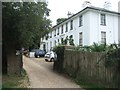
Living in PO35 5NL defines a life within a specific residential cluster on the Isle of Wight. This postcode serves a small population of approximately 1,580 people, creating an intimate neighbourhood feel. The area sits at a population density of 378 people per square kilometre, indicating a settled community without the pressure of high-density urban environments. Because PO35 5NL covers a small geographical footprint, daily life revolves around close proximity to local services and neighbours. You will find a setting that balances quiet residential space with reasonable access to broader transport links. The area is distinct for its stability and its focus on established housing rather than rapid development. Prospective buyers often seek this cluster for its manageable scale, where knowing your surroundings is a tangible reality rather than a marketing promise. Whether you arrive by car, rail, or ferry, the transition into PO35 5NL offers immediate access to a compact, well-defined part of the island. This small footprint ensures that distances to local amenities remain practical, making it suitable for those who value a structured, nearby lifestyle.
- Area Type
- Postcode
- Area Size
- Not available
- Population
- 1580
- Population Density
- 378 people/km²
The property market in PO35 5NL is defined by a distinct lack of rental options and a dominance of owner-occupied stock. With 85% home ownership, this area functions primarily as a market for buyers looking to settle down rather than landlords testing the waters. Accommodation types are limited to houses, which shapes the available inventory specifically for those seeking detached or semi-detected properties with associated outdoor space. This concentration of house-style homes within PO35 5NL means you will not find traditional flat-accessible rentals or communal apartment living here. The high ownership percentage signals a stable local market where residents build wealth through property rather than through rental yields. For buyers seeking entry into this area, competition may focus on established sellers who have lived there for decades. The smaller size of this residential cluster further concentrates the property stock, making every available house significant to the local market balance. This dynamic creates a predictable but potentially slower-moving market compared to areas with a high proportion of new build or rental schemes.
House Prices in PO35 5NL
No properties found in this postcode.
Energy Efficiency in PO35 5NL
Daily life in PO35 5NL is supported by a practical network of amenities located within practical reach. Residents benefit from five retail outlets, including The Southern Co-operative Co, The Southern Co-operative Co-op, and Tesco Ryde, meeting all essential shopping needs. Transport connectivity is extensive, with five rail stations nearby, including Brading Railway Station, Ryde St Johns Road Railway Station, and Sandown Railway Station. You can easily access surrounding towns by train. Two airports serve the area, namely Bembridge Airport and Isle of Wight / Sandown Airport, providing flight options for travel. Three metro-style transport links are available through Smallbrook Junction, the Isle of Wight Steam Railway, Ashey, and Havenstreet, adding tourist and leisure value. For those requiring sea travel, Ryde Hoverport and Fishbourne IOW Ferry Terminal offer two ferry crossings. This diverse range of facilities around PO35 5NL ensures that while the area is residential, it remains well-connected to commerce, travel, and leisure.
Amenities
Schools
| Rank | School | Type | Entry gender | Ages |
|---|
Explore more schools in this area
Go to Schools tabDemographics
The community in PO35 5NL reflects a mature and established demographic profile. The median age here is 47 years, and the most common age range consists of elderly residents aged 65 and over. This suggests a neighbourhood where families have settled permanently or where older generations remain close to childhood homes. Home ownership stands at an impressive 85%, confirming that the vast majority of households own their properties outright or with significant equity. This high level of ownership typically correlates with long-term residency and community stability. The predominant ethnic group within PO35 5NL is White, aligning with the broader demographic trends of many established areas on the Isle of Wight. Accommodation types are exclusively houses, meaning you will not find flats or apartment blocks within this specific postcode boundary. This housing composition supports a lifestyle centred around private gardens and detached living spaces. The profile indicates a quiet, non-transient environment where residents have invested in their local surroundings for the long haul rather than viewing homes as short-term investments.
Household Size
Accommodation Type
Tenure
Ethnic Group
Religion
Household Composition
Age
Household Deprivation
NS-SEC
Explore more demographic insights in this area
Go to Demographics tabPlanning
Planning Constraints
- Flood RiskPremium
- Ramsar Wetland SitesPremium
- Area of Outstanding Natural BeautyPremium
- Protected Nature ReservePremium
- Protected WoodlandPremium
- Crime RiskPremium