Area Overview for PO31 7XB
Photos of PO31 7XB


Area Information
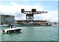
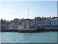
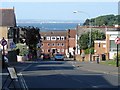
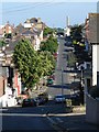
Living in PO31 7XB offers a distinct experience within the Island of Wight, defined by its compact footprint and proximity to key transport links. This specific postcode covers a small residential cluster of just 1529 square metres, yet it supports a population of 1524 people. The result is a tightly knit environment where neighbours are often near and daily life moves at a manageable pace. The area sits in the PO31 postcode zone, which is intrinsically linked to the ferry terminals and the town of Cowes. Residents benefit from immediate access to the East Cowes Floating Bridge, the East Cowes Ferry Terminal, and the Red Jet Ferry Terminal. These infrastructure points transform the location into a practical gateway for those who travel frequently between the mainland and the Island. Daily routines are shaped by this connectivity, allowing quick access to wider retail and employment hubs while maintaining a village-level feel. The residential density is high relative to the physical space, creating a purpose-built feel rather than a sprawling estate. Homebuyers here understand that convenience is built into the grid, with ferry terminals, retail parks, and railway stations all within a short reach.
- Area Type
- Postcode
- Area Size
- 1529 m²
- Population
- 1524
- Population Density
- 996804 people/km²
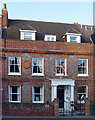
The property market in PO31 7XB is characterised by a stock dominated entirely by houses. There are no flats within this postcode, so buyers looking for houses in this area will find their requirements met exclusively by this housing type. With 51% of the population owning their homes, the area leans slightly towards owner-occupation. This balance means many properties have been lived in for significant periods, often resulting in a mix of maintained family homes and potential renovation projects. The high proportion of homeowners suggests a market driven by long-term residents rather than transient landlords. If you are searching for homes in PO31 7XB, you are entering a vernacular housing market where character often outweighs modern spec typical of new-build zones. The small area size of 1529 square metres limits the volume of turnovers but often supports higher competition for specific properties. Potential buyers should note that accommodation types are uniform; you will not encounter the diversity of a mixed-tenure estate. This consistency appeals to those seeking a traditional English house with a garden and driveway, rather than an apartment block.
House Prices in PO31 7XB
No properties found in this postcode.
Energy Efficiency in PO31 7XB
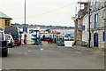
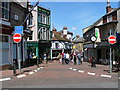
Daily life in PO31 7XB is convenient because major amenities cluster within a short distance. Retail options are plentiful, with five outlets located nearby, including Sainsburys West, Waitrose East, and M&S Cowes. You can handle your weekly shopping without needing a car for most items. Leisure and travel facilities are equally accessible, featuring five ferry terminals and three metro stations. The East Cowes Floating Bridge and the Red Jet Ferry Terminal provide scenic and fast routes to other destinations. Commuters often utilise the Ryde Pier Head Railway Station and Ryde Esplanade Railway Station for train travel to Portsmouth or London. There are also two metro stops, Wootton and Smallbrook Junction, which connect to the historic Isle of Wight Steam Railway for a leisurely ride. For residents of PO31 7XB, this density of services creates a lifestyle where practical errands and weekend trips coexist closely. You might grab groceries from Waitrose East on a Tuesday morning and catch a ferry to Cowes the next day. The mix of supermarkets, transport hubs, and local trade creates a functional ward where no significant journey is required for basic needs.
Amenities
Schools
| Rank | School | Type | Entry gender | Ages |
|---|
Explore more schools in this area
Go to Schools tabDemographics
The community in PO31 7XB is defined by a mature demographic profile where stability is common. The median age for residents is 47 years, and the most common age range comprises adults between 30 and 64 years. This suggests a neighbourhood where families with older children and empty-nesters form the backbone of the local society. White residents make up the predominant ethnic group, reflecting a homogeneous community structure typical of established English towns. Regarding housing tenure, 51% of households are owner-occupied, indicating that a slight majority of people have built equity in their homes rather than renting. The accommodation type is exclusively houses, meaning you will find detached, semi-detached, or terraced properties rather than flats or conversions within this specific grid. On safety grounds, the area carries a crime risk score of 76 out of 100. This figure signifies low crime risk, as the rate is below the national average. You can expect a generally secure environment where antisocial behaviour is not a primary concern for day-to-day living.
Household Size
Accommodation Type
Tenure
Ethnic Group
Religion
Household Composition
Age
Household Deprivation
NS-SEC
Explore more demographic insights in this area
Go to Demographics tabPlanning
Planning Constraints
- Flood RiskPremium
- Ramsar Wetland SitesPremium
- Area of Outstanding Natural BeautyPremium
- Protected Nature ReservePremium
- Protected WoodlandPremium