Area Overview for PO15 7PG
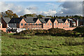
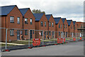
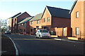
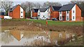
Photos of PO15 7PG


Area Information
Living in PO15 7PG means residing in a specific postcode cluster within Fareham, Hampshire. This small residential area covers just 2.5 hectares and houses a population of 2,716 people. You will find yourself in a neighbourhood defined by its compact nature, where the density reaches 124 people per square kilometre. This figure reflects a community that is tightly knit without being overcrowded. The location sits within the broader PO15 postcode sector, offering a quiet backdrop for everyday life. Residents here enjoy a settled environment away from the larger traffic flows of the surrounding motorways. The area serves as a convenient stopping point for those who work further afield yet wish to maintain a proximity to Southampton. You move into a setting where space is at a premium, creating a sense of closeness between neighbours. This small footprint ensures that local amenities are never far away, allowing for a straightforward daily routine. Whether you are walking to a shop or catching a train, the distances remain manageable. This postcode represents a stable, established part of the Hampshire landscape, prized for its practicality rather than expansive green belts.
- Area Type
- Postcode
- Area Size
- 2.5 hectares
- Population
- 2716
- Population Density
- 124 people/km²
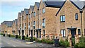
The property market in PO15 7PG is characterised largely by owner-occupation, with 80% of homes owned outright or with a mortgage held by the resident. This stands in stark contrast to the rental-led markets found in city centres. You are looking primarily at houses as the predominant accommodation type, meaning detached, semi-detached, and bungalows form the backbone of the housing stock. This mix appeals to families and couples seeking a private garden and standalone dwelling. The high percentage of home ownership indicates that new builds or student flats are rare here. Instead, the market focuses on existing properties that have served families for decades. Buying a home in PO15 7PG means joining an established community rather than moving into a temporary rental arrangement. The inventory is likely dominated by family-sized properties, including three and four-bedroom houses. You will find fewer purpose-built apartments compared to areas like central Southampton. The small size of the area, covering only 2.5 hectares, suggests a homogeneous market with limited variation in property types. Prices reflect this stability, driven by demand from those who cannot commit to a leasehold arrangement. The area serves as a stepping stone for commuters who require a owned-asset but want a short commute. It is a market defined by permanence and practicality.
House Prices in PO15 7PG
Showing 12 properties
| Address | Type | Beds | Baths | Last Sale Price | Last Sale Date | |
|---|---|---|---|---|---|---|
| 1 Sawpit Rise, Whiteley, PO15 7PG | house | - | - | - | - | |
| 11 Sawpit Rise, Whiteley, PO15 7PG | house | - | - | - | - | |
| 2 Sawpit Rise, Whiteley, PO15 7PG | house | - | - | - | - | |
| 5 Sawpit Rise, Whiteley, PO15 7PG | house | - | - | - | - | |
| 9 Sawpit Rise, Whiteley, PO15 7PG | house | - | - | - | - | |
| 8 Sawpit Rise, Whiteley, PO15 7PG | house | - | - | - | - | |
| 4 Sawpit Rise, Whiteley, PO15 7PG | house | - | - | - | - | |
| 6 Sawpit Rise, Whiteley, PO15 7PG | house | - | - | - | - | |
| 15 Sawpit Rise, Whiteley, PO15 7PG | house | - | - | - | - | |
| 17 Sawpit Rise, Whiteley, PO15 7PG | house | - | - | - | - |
Energy Efficiency in PO15 7PG
Your daily lifestyle in PO15 7PG benefits from a short drive to significant retail and transport hubs. Within practical reach, you can shop at Tesco Fareham, M&S Whiteley, and The Southern Co-operative Co. These large retailers cover most of your grocery and clothing needs without forcing you into a congested city centre. For your commute, five railway stations lie nearby, including Swanwick Railway Station, Botley Railway Station, and Bursledon Railway Station. These links connect you directly to London and the wider South East network. If your travel plans involve the coast or Eastleigh, two ferry landing points serve you: Warsash Ferry Landing and Hamble. For air travel, Southampton Airport offers two locations within a reasonable drive. These transport options provide flexibility for both business trips and weekend breaks. You do not need to live in the city to access international flights or coastal trains. The concentration of high street brands like The Southern Co-operative Co supports a comfortable local shopping experience. This blend of major supermarkets and rail connectivity defines the convenience of your home. You can run errands in Fareham and still catch a train to Waterloo quickly.
Amenities
Schools
Families living in PO15 7PG have access to two maintained primary schools within easy reach. Curdridge Primary School holds a good Ofsted rating, indicating it meets high standards of education and safeguarding. Nearby, Durley Church of England Controlled Primary School carries an outstanding Ofsted rating, making it a top choice for parents seeking excellence in primary education. Both schools serve the immediate neighbourhood and offer a stable educational environment for children. You will also find Vine School located close by, which operates as an independent institution. This mix of state and private provision offers parents options that suit their specific educational philosophies and budget constraints. The presence of an outstanding-rated state school is a significant asset for the area. Independent schooling is often preferred by some families who want a different curriculum or smaller class sizes. However, at Curdridge Primary and Durley Church of England Controlled Primary School, the state sector provides robust alternatives without the need for fees. The proximity of these three institutions means you do not need to travel far to secure a place for your child.竞争 for places may exist due to the high quality of Durley Church of England Controlled Primary School. Overall, the school catchment covers a range of academic performances and parental requirements.
| Rank | School | Type | Entry gender | Ages |
|---|
Explore more schools in this area
Go to Schools tabDemographics
The community in PO15 7PG is dominated by adults, with three-quarters of residents falling within the 30 to 64 years age range. The median age stands at 47, indicating a mature population profile typical of this part of Hampshire. You will find that 80% of households are owner-occupiers, suggesting a stable area where families stay put. This high rate of home ownership shapes the character of the locality, reducing turnover and fostering long-term community bonds. The predominant accommodation type consists of houses, catering to families and those seeking detached or semi-detached living. Demographically, White residents make up the vast majority of the population. This reflects the traditional makeup of the region. The age profile suggests fewer young children compared to more urban centres, but the presence of adults in their thirties and forties ensures a lively local scene. You are looking at a demographic that values stability and has likely built significant equity in their properties. The lack of a large student or young professional cohort means noise and traffic are generally lower. This steady demographic profile offers a predictable environment for retirees and families alike. The social fabric here is woven from long-term inhabitants who know their neighbours well.
Household Size
Accommodation Type
Tenure
Ethnic Group
Religion
Household Composition
Age
Household Deprivation
NS-SEC
Explore more demographic insights in this area
Go to Demographics tabPlanning
Planning Constraints
- Flood RiskPremium
- Ramsar Wetland SitesPremium
- Area of Outstanding Natural BeautyPremium
- Protected Nature ReservePremium
- Protected WoodlandPremium