Area Overview for PO1 3HG
Photos of PO1 3HG


Area Information
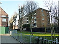
You are looking at a tight residential cluster defined by the postcode PO1 3HG, which sits within a specific 5588 square metre area. This small pocket of land in England packs a significant number of residents, holding a population of 2593 people. The result is a density of 1972 people per square kilometre, meaning you will live in close proximity to your neighbours. Because the space is so limited, the area functions as a compact living environment rather than a sprawling suburb. Life here is characterised by immediate access to urban centres but in a confined setting. You cannot expect large gardens or detached houses to be the norm given the sheer number of people living in such a small footprint. Instead, the focus is on efficient use of space. The location serves as a residential hub for the larger Portsmouth borough, drawing people who work or study nearby while benefiting from the convenience of a dense, walkable environment. Purchasing a home here means joining a community where daily routines are shaped by the proximity of local services and the vibrancy of shared public spaces.
- Area Type
- Postcode
- Area Size
- 5588 m²
- Population
- 2593
- Population Density
- 1972 people/km²
The property market in PO1 3HG is defined by a specific accommodation type: flats. This data points directly to a rental-led economy rather than an owner-occupied one. Only 10 per cent of residents own their homes. For the other 90 per cent, renting is the standard living arrangement. If you are considering buying a home in this postcode, you are entering a small, highly specific market with limited stock compared to wider suburbs. The local housing landscape consists almost entirely of flats designed for high-density living. This structure limits the variety of property types you will find here. There are no records of large detached houses or bungalows within this specific 5588 square metre zone. Potential buyers targeting family homes or garden spaces may find this area unsuitable. However, investors or individuals seeking a flat for rental income might find the low ownership rate an opportunity. The market reflects the needs of young adults who require affordable, low-maintenance living arrangements close to transport links.
House Prices in PO1 3HG
Showing 2 properties
| Address | Type | Beds | Baths | Last Sale Price | Last Sale Date | |
|---|---|---|---|---|---|---|
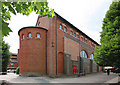
| Bishops House, Bishop Crispian Way, Portsmouth, PO1 3HG | Semi-detached | - | - | - | - | |
| Church Hall, Bishop Crispian Way, Portsmouth, PO1 3HG | commercial | - | - | - | - |
Energy Efficiency in PO1 3HG
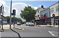
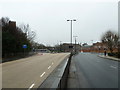
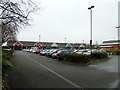
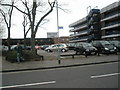
Your daily life in PO1 3HG includes immediate access to major retail outlets and transport arteries. Five retail shops are within practical reach, offering essential groceries and household goods. Notable superstores include Iceland Portsmouth, Sainsburys Portsmouth, and Tesco Portsmouth. You can shop for daily necessities without relying on long commutes to other cities. Transport connectivity is equally strong, with five railway stations nearby. These include Portsmouth & Southsea Railway Station, Portsmouth Harbour Railway Station, and Fratton Railway Station. If you need to access the wider region or the continent, five ferry terminals are close by. The Portsmouth Harbour Station Pier provides foot access, while the Portsmouth IOW Car Ferry Terminal and Portsmouth International Cruise & Ferry Terminal handle vehicle and passenger traffic. Living here means you have everything you need within a short walk or a brief drive. The presence of these large retail chains and major transport junctions creates a convenient, self-sufficient environment.
Amenities
Schools
| Rank | School | Type | Entry gender | Ages |
|---|
Explore more schools in this area
Go to Schools tabDemographics
The community in PO1 3HG is overwhelmingly young, with a median age of just 22 years. The most common age range for residents is 15 to 29 years, indicating that the area is dominated by students and young professionals. You will find that this demographic skew shapes the local culture and demand. Home ownership is low, standing at only 10 per cent. This figure suggests that the vast majority of residents rent their properties. Consequently, the accommodation type is primarily flats. Flats are the standard housing solution here, providing the density required for the population without necessitating extensive land. The predominant ethnic group is White, which reflects the typical urban distribution found in the wider region. With such a high concentration of young adults, you should expect a dynamic, fast-paced social environment where the lifecycle of the area revolves around education, employment, and socialising rather than family expansion.
Household Size
Accommodation Type
Tenure
Ethnic Group
Religion
Household Composition
Age
Household Deprivation
NS-SEC
Explore more demographic insights in this area
Go to Demographics tabPlanning
Planning Constraints
- Flood RiskPremium
- Ramsar Wetland SitesPremium
- Area of Outstanding Natural BeautyPremium
- Protected Nature ReservePremium
- Protected WoodlandPremium