Area Overview for Uffington
Photos of Uffington


Area Information
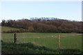
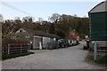
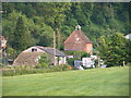
Living in Uffington offers a distinctly rural experience within the civil parish of this small community. You occupy a space defined by its compact size, covering just 11.9 km² of territory in southern England. This limited footprint shapes daily life, granting residents a close-knit environment where distances are short and local connections run deep. The setting provides a quiet retreat from urban pressure while maintaining links to nearby attractions and services. You find a location that values tradition and natural beauty over rapid development. The area functions as a self-contained neighbourhood where the pace of life slows down compared to larger towns. Your daily routine involves navigating a landscape where every road and path has been defined for generations. The civil parish structure ensures local governance focuses specifically on the needs of this concentrated population. When you move to Uffington, you step into a setting where community identity remains strong despite modern changes. The small scale of the parish makes it easy to understand where you live and how it fits into the broader region. Your home sits in a place where the land and the people have evolved together over time. This intimacy distinguishes Uffington from larger suburban developments found elsewhere.
- Area Type
- Parish
- Area Size
- 11.9 km²
- Population
- Not available
- Population Density
- Not available
Demographics
The community in Uffington reflects a mature society with a median age of 70 years. This high median figure indicates that the population is predominantly composed of older residents rather than young families. Most households consist of individuals or couples in later life stages, shaping the social fabric of the neighbourhood. You will find that 69% of residents own their homes outright or with a mortgage, demonstrating a very high rate of home ownership. This statistic suggests long-term stability within the community, as many people choose to settle permanently rather than rent. The scarcity of rental properties aligns with the older demographic profile where families have already completed their property purchases. You can expect a生活环境 where neighbours know each other after decades of shared residence. The age distribution shows a clear lack of young professionals or children moving into the area for work or education. This demographic reality means local services and amenities cater primarily to retirees and older working couples. When you consider living in Uffington, you join a stable community where settlement rates are historically high. The household composition reinforces this picture of permanence and established residency across the entire parish.
Household Size
Accommodation Type
Tenure
Ethnic Group
Religion
Household Composition
Age
Household Deprivation
NS-SEC
Explore more demographic insights in this area
Go to Demographics tabPlanning
Planning Constraints
- Flood RiskPremium
- Ramsar Wetland SitesPremium
- Area of Outstanding Natural BeautyPremium
- Protected Nature ReservePremium
- Protected WoodlandPremium