Area Overview for OX8 4SA
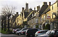
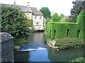
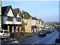
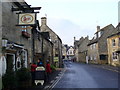
Photos of OX8 4SA


Area Information
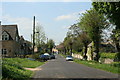
OX8 4SA represents a specific residential cluster within the Cotswolds, distinguished by its quiet, low-density character. The area contains a population of 1,977 residents spread across a space with very low density. With an average of only 73 people per square kilometre, this postcode offers significant room and a tranquil environment away from the busiest urban hubs. Buyers considering homes in OX8 4SA find a setting defined by its small scale and foregrounded residential nature. The address serves as a gateway to a lifestyle emphasising privacy and space rather than high street intensity. Daily life here revolves around the immediate neighbourhood and easy access to the wider Burford area without the pressure of congestion. This small residential cluster provides a stable backdrop for those seeking a retirement location, a family home, or a property to rent out. The distinct lack of crowding makes it a practical choice for residents who value open skies and a slower pace. Prospective owners should appreciate that this specific postcode area covers a modest footprint, meaning noise pollution and urban clutter are naturally limited. Living in OX8 4SA means choosing a settled environment where the community size allows for familiarity without overwhelming social complexity.
- Area Type
- Postcode
- Area Size
- Not available
- Population
- 1977
- Population Density
- 73 people/km²
Homes in OX8 4SA exist primarily within an owner-occupier market rather than a rental-heavy sector. With 65% of the housing stock owned by residents, the area functions as a location where people buy to stay. This high percentage of ownership contrasts sharply with London or major university towns where private renting dominates. The accommodation type is strictly houses, so you will not find flats or purpose-built apartments within this specific cluster. This means buyers looking at properties here are entering a market characterised by traditional housing stock rather than modern urban blocks. The nature of the market suggests that price movements may respond slower to short term shifts because owners are less likely to move frequently. For purchasers, this creates an environment where values are often driven by the quiet rivalry of neighbouring estate prices and the intrinsic quality of the house itself. You do not need to consider leasehold restrictions or shared ownership schemes commonly found in high density zones. Instead, focus on the solid ground of freehold homes and the stability of a neighbourhood where ownership is the norm. This steady market structure benefits those who view property as a permanent asset rather than a speculative investment.
House Prices in OX8 4SA
No properties found in this postcode.
Energy Efficiency in OX8 4SA
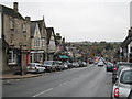
Residents of OX8 4SA enjoy convenient access to key amenities located within practical reach of the cluster. The nearest retail options include Co-op Burford, Co-op Centrum, and Co-op Brize, giving you three distinct superstores for your shopping needs. For rail travel, Shipton Railway Station and Ascott station provide the two nearest mainline connections to wider networks. An aviation facility nearby offers access to RAF Brize Norton, which may be relevant for specific industrial or military-related logistics. These amenities are not distant but form an integrated part of the daily routine for those calling this area home. You can attend to your household shopping at a Co-op location without needing to drive far. The proximity of Shipton Station ensures that travel to Coventry or other hubs is a straightforward commute. This mix of retail and transit facilities supports a self-contained lifestyle without requiring relocation to the city centre. The character of the area persists even as these services are fully accessible.
Amenities
Schools
Families living in OX8 4SA benefit from a cluster of educational institutions named explicitly for the locality. Burford School and Community College operates as a primary school situated near the residential zone. Burford School functions as an academy with a good Ofsted rating, providing robust secondary education options. Additionally, there are two references to Burford Primary School, indicating at least one strong primary option with a good Ofsted rating available to residents. This concentration of schools means you will find that schools near OX8 4SA are highly rated and focused on the specific needs of the local community. The presence of an academy alongside a community college shows a mix of funding and governance models, which often translates into stable, well-resourced classrooms. You can expect your children to attend a Burford entity without travelling far from home. The good Ofsted ratings across multiple institutions signal a high standard of academic delivery. This school ecosystem supports the family-oriented nature of the 30 to 64 age group who populate the area.
| Rank | School | Type | Entry gender | Ages |
|---|
Explore more schools in this area
Go to Schools tabDemographics
The community within OX8 4SA reflects a mature demographic profile dominated by adults aged between 30 and 64 years. The median age of 47 years indicates that the neighbourhood caters primarily to established households rather than single professionals or young children. Home ownership stands at 65%, which confirms that the vast majority of residents are likely to be long-term owners with significant equity rather than short-term renters. This high ownership rate suggests stability and a community invested in the long-term upkeep of their properties. Accommodation types are exclusively houses, ensuring that apartment living or converted flats are not a feature of this specific postcode. The predominant ethnic group is White, aligning with the traditional character of many areas in the Cotswolds. These housing conditions mean you will be joining a society where neighbours have likely lived in their properties for decades. The age distribution implies a quieter environment where families have grown and life has settled. You are buying into a market driven by those who value security and space over urban convenience or nightlife. The demographic data points clearly to a household composition focused on stability rather than transient living.
Household Size
Accommodation Type
Tenure
Ethnic Group
Religion
Household Composition
Age
Household Deprivation
NS-SEC
Explore more demographic insights in this area
Go to Demographics tabPlanning
Planning Constraints
- Flood RiskPremium
- Ramsar Wetland SitesPremium
- Area of Outstanding Natural BeautyPremium
- Protected Nature ReservePremium
- Protected WoodlandPremium