Area Overview for OX5 2UG
Photos of OX5 2UG


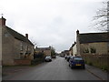


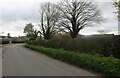


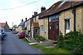

22 photos from this area
Area Information
Key information about the OX5 2UG including its size, population, and administrative classification.
- Area Type
- Postcode
- Area Size
- 1.9 hectares
- Population
- 1227
- Population Density
- 80 people/km²
House Prices in OX5 2UG
23
Properties
£497,953
Average Sold Price
£155,000
Lowest Price
£1,050,000
Highest Price
Showing 23 properties
| Address | Type | Beds | Baths | Last Sale Price | Last Sale Date | |
|---|---|---|---|---|---|---|
| Ivy Dene, High Street, Charlton On Otmoor, OX5 2UG | house | - | - | £1,050,000 | May 2022 | |
| The Old George And Dragon, High Street, Charlton On Otmoor, OX5 2UG | Semi-detached | 3 | 2 | £515,000 | Dec 2021 | |
| Lammas Cottage, High Street, Charlton On Otmoor, OX5 2UG | house | 2 | - | £420,000 | Feb 2021 | |
| Moors Edge, High Street, Charlton On Otmoor, OX5 2UG | Detached | 4 | 3 | £775,000 | Jun 2019 | |
| Newlands, High Street, Charlton On Otmoor, OX5 2UG | Semi-detached | 3 | 2 | £400,000 | Nov 2015 | |
| Halton House, High Street, Charlton On Otmoor, OX5 2UG | Detached | - | - | £590,000 | Sep 2009 | |
| Rectory Farm Barn, High Street, Charlton On Otmoor, OX5 2UG | house | - | - | £740,000 | May 2007 | |
| Otmoor House, High Street, Charlton On Otmoor, OX5 2UG | Detached | 5 | 2 | £610,000 | Jun 2006 | |
| Inglenook Cottage, High Street, Charlton On Otmoor, OX5 2UG | Cottage | 3 | 2 | £250,000 | Aug 2002 | |
| Southcot, High Street, Charlton On Otmoor, OX5 2UG | Detached | - | - | £275,000 | Jul 2001 |
Page 1 of 3
Energy Efficiency in OX5 2UG
Amenities
Schools
| Rank | School | Type | Entry gender | Ages |
|---|
Explore more schools in this area
Go to Schools tabDemographics
Household Size
Two person
most common
Accommodation Type
Houses
most common
Tenure
82
majority
Ethnic Group
White
most common
Religion
N/A
most common
Household Composition
N/A
most common
Age
47
median
Adults (30-64 years)
most common
Household Deprivation
N/A
with no deprivation
NS-SEC
52
in Lower managerial occupations
Explore more demographic insights in this area
Go to Demographics tabPlanning
Planning Constraints
- Flood RiskPremium
- Ramsar Wetland SitesPremium
- Area of Outstanding Natural BeautyPremium
- Protected Nature ReservePremium
- Protected WoodlandPremium