Area Overview for OX39 4PG
Photos of OX39 4PG


100 photos from this area
Area Information
Key information about the OX39 4PG including its size, population, and administrative classification.
- Area Type
- Postcode
- Area Size
- 7170 m²
- Population
- 1856
- Population Density
- 212 people/km²
House Prices in OX39 4PG
13
Properties
-
Average Sold Price
-
Lowest Price
-
Highest Price
Showing 13 properties
| Address | Type | Beds | Baths | Last Sale Price | Last Sale Date | |
|---|---|---|---|---|---|---|
| Dragons, Church Road, Chinnor, OX39 4PG | Detached | 3 | 1 | - | - | |
| Weights Fitness Studio, 24A Church Road, Chinnor, OX39 4PG | Leisure | - | - | - | - | |
| Godwins Bakery, 26 Church Road, Chinnor, OX39 4PG | restaurant_cafe | - | - | - | - | |
| Plested Butchers, 20 Church Road, Chinnor, OX39 4PG | shop | - | - | - | - | |
| Lloyds Pharmacy, 28 Church Road, Chinnor, OX39 4PG | retail_financial | - | - | - | - | |
| Flat 5, 28 Church Road, Chinnor, OX39 4PG | Flat | - | - | - | - | |
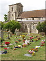
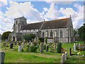
| Graveyard, St Andrews Church, Church Road, Chinnor, OX39 4PG | commercial | - | - | - | - | |
| Flat, 26 Church Road, Chinnor, OX39 4PG | Flat | - | - | - | - | |
| Flat 1, 20 Church Road, Chinnor, OX39 4PG | Flat | - | - | - | - | |
| Chinnor Mini Mart, 30 Church Road, Chinnor, OX39 4PG | shop | - | - | - | - |
Page 1 of 2
Energy Efficiency in OX39 4PG
Amenities
Schools
| Rank | School | Type | Entry gender | Ages |
|---|
Explore more schools in this area
Go to Schools tabDemographics
Household Size
Two person
most common
Accommodation Type
Houses
most common
Tenure
84
majority
Ethnic Group
White
most common
Religion
N/A
most common
Household Composition
N/A
most common
Age
47
median
Adults (30-64 years)
most common
Household Deprivation
N/A
with no deprivation
NS-SEC
44
in Lower managerial occupations
Explore more demographic insights in this area
Go to Demographics tabPlanning
Planning Constraints
- Flood RiskPremium
- Ramsar Wetland SitesPremium
- Area of Outstanding Natural BeautyPremium
- Protected Nature ReservePremium
- Protected WoodlandPremium