Area Overview for OX39 4EE
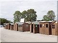
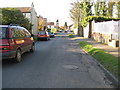
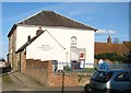
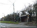
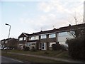
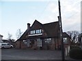
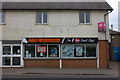
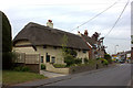
Photos of OX39 4EE


Area Information
OX39 4EE is a defined residential cluster covering just over two and a half thousand square metres. This small footprint supports a population of 1,856 people, resulting in a density of 212 individuals per square kilometre. Living in this postcode means residing within a tightly knit environment where neighbours are inevitably close. The area functions as a specific pocket of housing rather than a sprawling suburb. One thousand eight hundred and fifty-six residents share this space, creating a sense of locality without the congestion of larger towns. You will find yourself in an England-based community where the layout dictates a quiet, contained lifestyle. The sheer scale is modest, yet it accommodates a steady number of households. This concentration of population within such a small geographical boundary defines the character of the location. It is a place where daily routines involve walking short distances and engaging with a limited, familiar circle of streets. The area stands apart from broad neighbourhoods because its boundaries are precise and its total area is minimal.
- Area Type
- Postcode
- Area Size
- 2580 m²
- Population
- 1856
- Population Density
- 212 people/km²
Living in OX39 4EE involves purchasing into a market dominated by freehold homes. The accommodation type is exclusively houses, meaning you will not encounter flats or bungalows as the primary housing stock. Home ownership rates stand at 84 per cent, signaling that the vast majority of properties are owned by their occupants. This high tenure rate typically results in a housing market where sellers have the choice to sell when they decide, rather than needing tenant approval for viewings or sales. You are looking at a selection of houses that cater to families and individuals who have stayed in the area for the long term. The property market here is intimate due to the small total area size of the postcode. Homes in this location command steady demand from buyers who prioritise stability over rapid development options. With 84 per cent ownership, the rental sector plays a minor role in the local economy. Buyers should expect to compete for houses that have remained in the same hands for many years. The market reflects a community where property changes hands less frequently than in more dynamic rental areas.
House Prices in OX39 4EE
Showing 6 properties
| Address | Type | Beds | Baths | Last Sale Price | Last Sale Date | |
|---|---|---|---|---|---|---|
| 2 Elderdene, Chinnor, OX39 4EE | Bungalow | 2 | 1 | £225,000 | Jun 2012 | |
| 5 Elderdene, Chinnor, OX39 4EE | Semi-detached | - | - | £140,000 | Oct 2001 | |
| 3 Elderdene, Chinnor, OX39 4EE | Retail | 4 | 2 | £94,500 | Sep 1998 | |
| 4 Elderdene, Chinnor, OX39 4EE | Detached | 3 | - | - | - | |
| 59 Elderdene, Chinnor, OX39 4EE | Detached | - | - | - | - | |
| 58 Elderdene, Chinnor, OX39 4EE | Bungalow | - | - | - | - |
Energy Efficiency in OX39 4EE
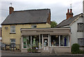
Daily life in OX39 4EE benefits from immediate access to practical shopping and rail transport. There are five notable retail outlets within reach, including Co-op Chinnor, Waitrose Little Waitrose, and Co-op Princes. These venues supply groceries and essentials without requiring long journeys for basic household needs. Travel connections are robust with five nearby stations, such as Princes Risborough Railway Station, Monks Risborough Railway Station, and Saunderton Railway Station. You can access regional networks through these points, making commutes to Oxford, Aylesbury, or London a reliable part of your routine. The presence of Waitrose suggests a focus on quality food and reliable supermarket services. Local residents utilise this railway access to maintain connections with broader employment hubs. The combination of local shops and major stations creates a convenient lifestyle where daily tasks are manageable. Shopping trips are short, and train journeys begin within a short drive or walk. This mix of amenities reduces the strain on time and fuel for ordinary weekly activities.
Amenities
Schools
| Rank | School | Type | Entry gender | Ages |
|---|
Explore more schools in this area
Go to Schools tabDemographics
The community within OX39 4EE reflects a mature population with a median age of 47 years. The most common age range for local residents consists of adults between 30 and 64 years old. Home ownership stands at 84 per cent, indicating that the vast majority of residents live in their own properties rather than renting. Houses form the predominant accommodation type throughout this postcode. The predominant ethnic group is White. An ownership rate of 84 per cent suggests a stable, settled community where families and long-term residents form the backbone of the neighbourhood. This high level of tenure contrasts with areas that rely heavily on the rental sector. The age profile points to a demographic often found in established suburban zones outside major cities. With a median age near 47, the area attracts those seeking stability. The housing stock matches these residents, focusing on houses rather than high-density flats. Nearly nine out of ten residents own their homes, reinforcing the idea of a permanent resident base.
Household Size
Accommodation Type
Tenure
Ethnic Group
Religion
Household Composition
Age
Household Deprivation
NS-SEC
Explore more demographic insights in this area
Go to Demographics tabPlanning
Planning Constraints
- Flood RiskPremium
- Ramsar Wetland SitesPremium
- Area of Outstanding Natural BeautyPremium
- Protected Nature ReservePremium
- Protected WoodlandPremium