Area Overview for OX3 7TD
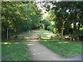
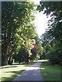
Photos of OX3 7TD


Area Information
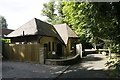
Living in OX3 7TD means residing within a compact residential cluster that covers exactly 1.4 hectares. You will find 2,314 people calling this specific postcode home, creating a defined neighbourhood rather than a sprawling district. The area is situated in Oxford, England, and its small size suggests a close-knit environment where residents know each other well. Daily life here revolves around the immediate surroundings, with most amenities and transport links located within practical reach of every doorstep. The population density is high at 163,313 people per square kilometre, indicating a built-up area where land is used efficiently. This density supports a convenient lifestyle without the need for long commutes to local services. You are not looking for a vast suburb with miles of green space to traverse; instead, you are entering a dense pocket of Oxford where everything is accessible on foot or by a short bus journey. The area functions as a self-contained residential unit that offers a direct link to the wider city while maintaining a distinct local identity. Prospective buyers will find that OX3 7TD prioritises proximity to the city centre over expansive open fields.
- Area Type
- Postcode
- Area Size
- 1.4 hectares
- Population
- 2314
- Population Density
- 2432 people/km²
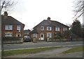
The property market in OX3 7TD is characterised by a stock dominated by houses, which sets it apart from the city centre's prevalence of flats. With 62 per cent of residents owning their homes, this is primarily an owner-occupied area rather than a rental hotspot. This high rate of home ownership implies that a significant portion of the housing stock consists of established properties that have withstood market fluctuations over time. You are likely to find detached or semi-detached homes that suit those seeking more space than a flat can provide. The accommodation type of houses means that buyers looking for garden space or private outdoor areas will find this postcode area more suitable than the nearby high-density clusters. The low population density of 1.4 hectares means that properties are likely to be clustered efficiently but still offer residential privacy. For sellers, the owner-occupied status often leads to stronger demand from families or individuals seeking a permanent base in Oxford. When you look at homes in OX3 7TD, you are entering a market where stability meets the practical needs of a younger demographic who value space away from high-rise living.
House Prices in OX3 7TD
Showing 12 properties
Energy Efficiency in OX3 7TD
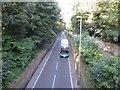
Your lifestyle in OX3 7TD is supported by a convenient range of amenities located within practical reach. Five major retail outlets are situated nearby, allowing you to complete most shopping trips without a dedicated journey. You can find branches of Co-op Oxford, Waitrose Little Waitrose Shell, and Sainsburys Oxford close to the postcode, ensuring a wide variety of food and household goods are available. For rail travel, three stations are within easy distance: Oxford Parkway Railway Station, Islip Railway Station, and Radley Railway Station. These transport hubs connect you to wider destinations without long detours. Daily life involves a balance of accessing high-standard supermarkets and maintaining easy access to public transport networks. There are no parks or leisure centres listed in the immediate amenity data, so your leisure activities may rely on the wider Oxford offerings. The presence of major retailers like Waitrose and Sainsburys means you have access to fresh produce and quality goods locally. Living in OX3 7TD provides a pragmatic lifestyle where essential services are nearby but the area remains focused on residential living.
Amenities
Schools
Families considering moving to OX3 7TD have access to a selection of educational institutions within practical reach. St Joseph's Catholic Primary School is located nearby and holds a good Ofsted rating, offering a state-sector education option for younger children. Milham Ford Girls' School also serves the primary age group, providing an alternative local option. For independent education, residents can access Headington Rye Oxford and Rye St Antony, which offer private schooling for those who prefer that route. As children grow older, Plater College acts as a sixth-form college, delivering post-16 education in the vicinity. The mix of state primary schools, independent primaries, and a sixth-form college ensures there are options available for various educational preferences and budgets. Living in OX3 7TD means you do not need to travel far to secure a schooling place for your child. The presence of five schools listed in the general area, including these specific names, provides a robust educational network. This variety is particularly useful if you are comparing state versus independent formats or if your child needs a sixth-form option close to home.
| Rank | School | Type | Entry gender | Ages |
|---|
Explore more schools in this area
Go to Schools tabDemographics
The community in OX3 7TD is defined by a youthful demographic, with a median age of just 22 years. This figure is lower than the national average and suggests the area attracts younger residents who are likely building their careers or starting families. The most common age range for those living here falls between 15 and 29 years, meaning you will encounter a neighbourhood full of energy and ambition. Home ownership is relatively high at 62 per cent, which indicates stability and long-term settlement rather than a transient student population. This level of ownership suggests that many residents have put down roots and are invested in the local community. The predominant ethnic group is White, aligning with the broader demographic trends of the region. Accommodation types are primarily houses, offering a traditional living experience rather than high-density apartments. There is no data provided regarding specific deprivation indices, so the focus remains on the established nature of the housing stock. For families considering living in OX3 7TD, the combination of young adults and home ownership points to a dynamic but settled environment where people are focused on their personal growth and career establishment.
Household Size
Accommodation Type
Tenure
Ethnic Group
Religion
Household Composition
Age
Household Deprivation
NS-SEC
Explore more demographic insights in this area
Go to Demographics tabPlanning
Planning Constraints
- Flood RiskPremium
- Ramsar Wetland SitesPremium
- Area of Outstanding Natural BeautyPremium
- Protected Nature ReservePremium
- Protected WoodlandPremium