Area Overview for OX29 8SU
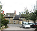
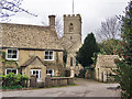
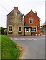
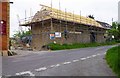
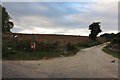
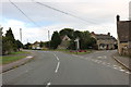
Photos of OX29 8SU


Area Information
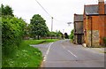
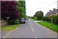
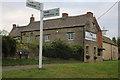
Living in OX29 8SU means occupying a specific residential cluster defined by its postcode location in Oxfordshire. This small area accommodates a population of 1,435 residents, creating a close-knit environment with a density of 236 people per square kilometre. The geography supports traditional domestic life rather than high-density urban living. You can expect a sheltered setting where daily movement relies on local amenities and occasional travel to nearby towns. The area functions as a quiet retreat while remaining accessible to broader transport networks. Its compact nature fosters a sense of community where neighbours likely know one another well. The postcode covers houses that cater to families and individuals seeking stability away from the hustle of the city centre. You are stepping into a location where the pace of life is governed by the seasons and local trade, not by commuting crowds. The residential cluster offers a defined boundary for those wishing to understand exactly where their property lies within the wider district. This specificity helps in planning your routine, from locating the nearest shop to estimating travel times to Oxford. The area embodies a particular type of English suburban life that values privacy and space above metropolitan convenience.
- Area Type
- Postcode
- Area Size
- Not available
- Population
- 1435
- Population Density
- 236 people/km²
The property market in OX29 8SU is dominated by existing stock rather than new builds or high turnover rental units. With a home ownership rate of 77%, the area functions as a landlord-free zone for the majority of its occupants. This statistic presents a clear picture for buyers: you are looking at a community where people intend to stay. The accommodation type is exclusively houses, meaning you will not find flats or converted apartments within this specific postcode boundary. This housing mix supports families who require multiple bedrooms and gardens, rather than urban dwellers needing compact living units. Buying here means joining a market where legacy homes typically drive values, though the small population of 1,435 limits larger investment pools. The sheer number of properties for sale will be low compared to urban centres, so opportunities may be scarce but competition often less intense. For investors, the 77% ownership rate suggests difficulty finding rental yield unless targeting the remaining 23% of homeowners who might be forced to sell. However, for a first-time buyer or upgrader, potential exists to acquire a solid asset from a seller who views the home as heritage rather than a commodity. The market dynamics here are slower, favouring careful due diligence over quick transactions.
House Prices in OX29 8SU
No properties found in this postcode.
Energy Efficiency in OX29 8SU
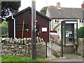
Residents of OX29 8SU enjoy convenient access to five railway stations including Finstock, Combe, and Charlbury. These rail links provide the primary method for extending your daily reach beyond the local village. You can reach Oxford or London with relative ease, depending on your specific destination and train schedule. The area also benefits from five retail outlets, most notably the Co-op branches in Long, Charlbury, and Woodstock. These supermarkets form the backbone of local shopping, offering daily necessities without requiring trips to distant city centres. Two airports, Oxford Kidlington and London Oxford, are within practical reach of this postcode. While driving might be necessary for airport transfers, their proximity indicates a well-connected region. This network of transport and retail options means you do not need to leave the county for basic errands or weekend trips. The availability of Co-op stores ensures fresh food, banking, and pharmacy services are available locally. Rail stations like Charlbury provide a direct link to broader job markets. This infrastructure supports a self-sufficient lifestyle where you can manage bills, shop for clothes, and catch a train all within a short drive. The combination of rail and retail creates a balanced ecosystem for everyday life.
Amenities
Schools
Families living in OX29 8SU have direct access to Stonesfield Primary School, which holds a good Ofsted rating. This establishment serves as the primary educational gateway for young children within the immediate vicinity. Its good rating indicates a standard of teaching and care that meets government expectations without compromising on student welfare. While this data does not list secondary options, the presence of a rated primary school confirms that early years education is well supported nearby. You can expect lessons delivered in a environment that balances academic rigor with pastoral care. The single school entry suggests a focused catchment area where transport logistics are straightforward compared to sprawling districts with dozens of options. If you have multiple children at different stages, you may need to travel further for secondary education, as the provided data only confirms primary provision. The existence of Stonesfield Primary School anchors the local community, providing a predictable routine for families. Its status as a good school removes immediate anxiety regarding the foundational years of a child's education. Parents can rely on consistent performance metrics when making decisions about where to buy homes in OX29 8SU. The clarity of the school's rating offers a tangible benchmark for evaluating family suitability.
| Rank | School | Type | Entry gender | Ages |
|---|
Explore more schools in this area
Go to Schools tabDemographics
The community in OX29 8SU reflects a mature household demographic with a median age of 47 years. Most residents fall into the adult range between 30 and 64 years old, suggesting a stable population focused on established careers or retirement. Seven out of every ten households in this postcode area own their home, reaching a home ownership rate of 77%. This high figure indicates low pressure from short-term rentals or developer build-outs. The accommodation stock consists almost entirely of houses, aligning with the older population profile and preference for detached or semi-detached living spaces. The predominant ethnic group is White, which mirrors the broader societal makeup of rural Oxfordshire but suggests a homogeneous community where cultural values may be longstanding. This lack of demographic volatility can appeal to those seeking consistency and familiarity in their daily surroundings. You can expect a neighbourhood where long-term residents make up the bulk of the social fabric. The age profile implies that the area is less oriented toward teenagers entering university or young adults starting their first homes. Instead, it serves established families and empty nesters who have put down roots and likely plan to remain for the long term.
Household Size
Accommodation Type
Tenure
Ethnic Group
Religion
Household Composition
Age
Household Deprivation
NS-SEC
Explore more demographic insights in this area
Go to Demographics tabPlanning
Planning Constraints
- Flood RiskPremium
- Ramsar Wetland SitesPremium
- Area of Outstanding Natural BeautyPremium
- Protected Nature ReservePremium
- Protected WoodlandPremium