Area Overview for OX2 8DF
Photos of OX2 8DF

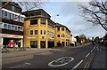
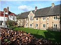
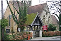
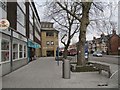
100 photos from this area
Area Information
Key information about the OX2 8DF including its size, population, and administrative classification.
- Area Type
- Postcode
- Area Size
- 1.4 hectares
- Population
- 1447
- Population Density
- 2289 people/km²
House Prices in OX2 8DF
17
Properties
£785,059
Average Sold Price
£210,000
Lowest Price
£1,753,211
Highest Price
Showing 17 properties
| Address | Type | Beds | Baths | Last Sale Price | Last Sale Date | |
|---|---|---|---|---|---|---|
| 9 Wyndham Way, Oxford, OX2 8DF | Detached | 4 | 2 | £1,407,500 | Sep 2025 | |
| 2B Wyndham Way, Oxford, OX2 8DF | Detached | 4 | 2 | £1,753,211 | Jul 2022 | |
| The Gables, 1A Wyndham Way, Oxford, OX2 8DF | Detached | 4 | 2 | £935,000 | Jun 2022 | |
| 2 Wyndham Way, Oxford, OX2 8DF | house | - | - | £1,130,000 | Aug 2021 | |
| 2A Wyndham Way, Oxford, OX2 8DF | Bungalow | 3 | - | £850,000 | May 2016 | |
| 5 Wyndham Way, Oxford, OX2 8DF | Detached | 3 | - | £690,000 | Nov 2013 | |
| 7 Wyndham Way, Oxford, OX2 8DF | house | - | - | £625,000 | Aug 2009 | |
| 4 Wyndham Way, Oxford, OX2 8DF | Detached | - | - | £655,000 | Oct 2006 | |
| 8 Wyndham Way, Oxford, OX2 8DF | house | - | - | £560,000 | Jul 2003 | |
| 13 Wyndham Way, Oxford, OX2 8DF | Detached | - | - | £382,500 | Apr 2003 |
Page 1 of 2
Energy Efficiency in OX2 8DF
Amenities
Schools
| Rank | School | Type | Entry gender | Ages |
|---|
Explore more schools in this area
Go to Schools tabDemographics
Household Size
One person
most common
Accommodation Type
Houses
most common
Tenure
67
majority
Ethnic Group
White
most common
Religion
N/A
most common
Household Composition
N/A
most common
Age
47
median
Adults (30-64 years)
most common
Household Deprivation
N/A
with no deprivation
NS-SEC
62
in Lower managerial occupations
Explore more demographic insights in this area
Go to Demographics tabPlanning
Planning Constraints
- Flood RiskPremium
- Ramsar Wetland SitesPremium
- Area of Outstanding Natural BeautyPremium
- Protected Nature ReservePremium
- Protected WoodlandPremium