Area Overview for OX2 6DQ
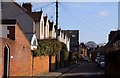
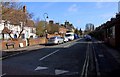
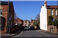
Photos of OX2 6DQ


Area Information
OX2 6DQ represents a specific residential cluster within England, defined by precise geographic boundaries rather than a broad locality. This small area covers 1,567 square metres of land and serves a population of 1,433 residents. Living in OX2 6DQ means you are part of a tightly knit community where every property is close to another. The scale of this postcode ensures that daily life revolves around immediate neighbours and local facilities. You will find the area functions as a quiet residential pocket, distinct from the wider Oxford region yet fully integrated into its transport networks. The compact nature of the site creates a sense of proximity that larger neighbourhoods often lack. Your daily commute likely starts with a short walk to local amenities before you reach major railway stations or motorways. This configuration suits those who prefer a hidden home base while remaining close to the city's main arteries. The area's identity is tied to its specific postcode designation, which governs everything from local council services to postal delivery routes. Understanding this micro-context helps you grasp the unique rhythm of life here.
- Area Type
- Postcode
- Area Size
- 1567 m²
- Population
- 1433
- Population Density
- 9293 people/km²
The property market in OX2 6DQ is defined by a predominance of houses rather than flats or purpose-built blocks. Only 21% of residents own their homes, which places local houses firmly in the rental market for the majority. This dynamic suggests that if you are looking to buy, competition may be stiffer as many households remain tenants. Alternatively, sellers of rental properties in OX2 6DQ hold a significant portion of the local housing stock. The accommodation type data confirms that traditional detached, semi-detached, and terraced houses form the core of the area. This housing stock likely consists of older buildings typical of the region, rather than modern developments. Buyers focusing on owner-occupation will need to navigate a sector where rental demand keeps vacancy rates low. The small area size of 1,567 square metres limits the volume of available properties at any one time. You must act quickly if you identify a suitable property, as the number of listings will naturally be limited by the total land area covered by the postcode.
House Prices in OX2 6DQ
Showing 9 properties
| Address | Type | Beds | Baths | Last Sale Price | Last Sale Date | |
|---|---|---|---|---|---|---|
| 7 Allam Street, Oxford, OX2 6DQ | house | - | - | £1,750,000 | May 2024 | |
| 6 Allam Street, Oxford, OX2 6DQ | Terraced | 3 | 1 | £559,750 | Feb 2018 | |
| 4 Allam Street, Oxford, OX2 6DQ | Terraced | - | - | £308,000 | Sep 2003 | |
| Castelfelino, 1 Allam Street, Oxford, OX2 6DQ | Semi-detached | - | - | £141,000 | Jun 1996 | |
| 8 Allam Street, Oxford, OX2 6DQ | Terraced | 3 | 2 | - | - | |
| 9 Allam Street, Oxford, OX2 6DQ | house | - | - | - | - | |
| 5 Allam Street, Oxford, OX2 6DQ | Terraced | - | - | - | - | |
| 3 Allam Street, Oxford, OX2 6DQ | Terraced | - | - | - | - | |
| 1A Allam Street, Oxford, OX2 6DQ | house | - | - | - | - |
Energy Efficiency in OX2 6DQ
Residents of OX2 6DQ benefit from a diverse array of nearby amenities within practical reach. You have access to five retail outlets, including major chains like Sainsburys Oxford, Co-op Walton, and Co-op Little for your grocery and daily shopping needs. Three railway stations serve the area, offering straightforward links to Oxford Parkway, Islip, and Radley, which feed into wider national networks. Two airports lie close by, namely London Oxford Airport and Oxford Kidlington Airport, providing options for personal travel or business trips. These amenities create a convenient environment where you can manage most daily requirements without travelling long distances. The proximity to these transport hubs means you can reach Oxford city centre or London airports without excessive delays. Your morning routine might involve a train from one of the three nearby stations rather than a car. The concentration of supermarkets and rail links ensures that lifestyle convenience remains a central feature of life in OX2 6DQ.
Amenities
Schools
St Barnabas Church of England Aided Primary School stands as the only named educational facility near OX2 6DQ. This primary school operates under the Church of England Aided charitable status and holds a satisfactory Ofsted rating. Living in OX2 6DQ offers direct access to this single primary option for young children. The school's satisfactory rating indicates it meets the required standards set by the Education and Skills Funding Agency, though it may not be judged outstanding in every inspection cycle. Before you decide on this postcode for your children's future, note that no secondary schools or specialist academies appear in the immediate vicinity of this small cluster. Families must look beyond the immediate OX2 6DQ boundaries to find high schools or further education colleges. The presence of just one listed school means that travel time to education can fluctuate significantly depending on which destination you target outside the postcode. Schools near OX2 6DQ are limited to this primary institution, so parents should plan accordingly.
| Rank | School | Type | Entry gender | Ages |
|---|
Explore more schools in this area
Go to Schools tabDemographics
The community in OX2 6DQ reflects a mature demographic profile, with a median age of 47 years. Most residents fall into the adult age range of 30 to 64 years, indicating a stable population of established working individuals and families. Home ownership stands at 21%, suggesting that the vast majority of the population rents their accommodation from landlords or housing associations. Houses dominate the accommodation type, meaning terraced and semi-detached dwellings form the physical fabric of OX2 6DQ rather than extended flats or purpose-built blocks. The predominant ethnic group is White, which aligns with the broader pattern found in much of the surrounding Oxfordshire region. Deprivation is not highlighted in the available figures, so financial hardship cannot be assessed directly from current data. The low ownership rate of 21% implies high demand for rental properties among adults in this age bracket. You can expect a fairly homogenous community where neighbours have lived in the area for many years. The concentration of adults between 30 and 64 creates a relatively settled environment without the influx of very young families or a large retiree population.
Household Size
Accommodation Type
Tenure
Ethnic Group
Religion
Household Composition
Age
Household Deprivation
NS-SEC
Explore more demographic insights in this area
Go to Demographics tabPlanning
Planning Constraints
- Flood RiskPremium
- Ramsar Wetland SitesPremium
- Area of Outstanding Natural BeautyPremium
- Protected Nature ReservePremium
- Protected WoodlandPremium