Area Overview for OX18 4UL
Photos of OX18 4UL


Area Information
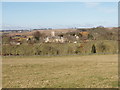
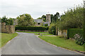
Living in OX18 4UL means residing within a specific residential cluster defined by the OX18 postcode in England. This small area houses a population of 1,977 people across a relatively large footprint, resulting in a density of just 73 people per square kilometre. The low density creates a spacious, quiet environment far removed from the congestion of city centres or large towns. Residents here enjoy a residential focus without the pressure of high-density urban living. The area stands apart as a defined locality rather than a sprawling town, offering a settled rhythm to daily life. You will find yourself in a neighbourhood where houses dominate the landscape, providing a sense of personal space and privacy. Although the area covers a limited geographic scope, its isolation from major congestion points makes it an attractive option for those seeking calm. The distinct character of this postcode area ensures a straightforward, uncluttered living experience. It is a place where the pace of life is controlled by distance to services, not by road traffic. You get a clear definition of your surroundings, bounded by what the postal system defines as this specific cluster.
- Area Type
- Postcode
- Area Size
- Not available
- Population
- 1977
- Population Density
- 73 people/km²
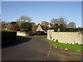
The property market in OX18 4UL reflects a market dominated by owner-occupiers rather than landlords or investors. With 65% of homes owned by their residents, the area feels like a community of people who have put down permanent roots. This figure leaves only 35% of the population in rented accommodation, a proportion typical for established suburban clusters. The accommodation type data confirms that houses are the primary housing form in this postcode. You will find that specific postcodes like OX18 4UL prioritise standalone homes over flats or apartments. This structure appeals to families or individuals seeking space and garden access, which aligns with the 47-year median age of residents. Buying here means entering a market where resale value often correlates with the stability of the existing community. The prevalence of houses means you are looking at properties with established tenure and established service histories. There is little scope for the rapid turnover seen in student enclaves or dense city centres. The market is defined by these substantial, house-based assets held by the majority of its inhabitants.
House Prices in OX18 4UL
No properties found in this postcode.
Energy Efficiency in OX18 4UL
Lifestyle in OX18 4UL revolves around practical amenities located within practical reach of your home. Retail needs are met by three convenience stores: Co-op Burford, Co-op Milton-U, and Co-op Upper. These three branches provide essential groceries and daily supplies without necessitating long travel times. For rail travel, three stations are within reasonable distance: Shipton Railway Station, Ascott, and Kingham Railway Station. These links connect you to the wider network for commutes or weekend trips. While there is only one airport nearby, RAF Brize Norton, its primary value lies in logistics and industry rather than consumer air travel. This means your daily life depends more on the Co-op branches and the railway stations for getting your week done. The concentration of three local food shops ensures that fresh produce and everyday items are always accessible. You do not need to drive far for basic necessities, which enhances the convenience of this residential cluster. The layout supports a self-sufficient daily routine anchored by these specific service points.
Amenities
Schools
Education for residents of OX18 4UL is supported by a cluster of schools located nearby. You have access to Burford Primary School, which holds a good Ofsted rating, ensuring a high standard of education for younger children. Another primary option is Burford School and Community College, which also carries a good rating for similar age groups. For secondary education, Burford School stands out as a national academy with a good Ofsted rating. This combination of primary and academy-level provision means families moving into this area have convenient access to state schools without needing to travel far for top-tier education. Having multiple options with good ratings simplifies the decision-making process for parents considering OX18 4UL. The presence of both community and academy trusts provides a mix of educational approaches within a short distance. You do not need to look outside the local vicinity to find reputable schooling for your children. The concentration of good-rated institutions suggests a family-friendly environment where education is a priority for the local demographic.
| Rank | School | Type | Entry gender | Ages |
|---|
Explore more schools in this area
Go to Schools tabDemographics
The community in OX18 4UL is characterised by a mature household profile centred on adults aged between 30 and 64 years. The median age across the 1,977 residents is 47 years, indicating a stable population of working families and professionals rather than a transient student body. Home ownership stands at 65%, which is a significant majority and suggests a settled community where most residents own their accommodation. This high ownership rate contrasts with rental-heavy markets often found in university towns or major cities. The predominant ethnic group is White, reflecting the area's traditional demographic composition. Accommodation is almost exclusively made up of houses, aligning with the low-density nature of the postcode. You will not find high-rise blocks or terraced streets here; the housing stock consists of detached or semi-detached properties suited to this age profile. The demographic data paints a picture of a quiet, established neighbourhood where long-term residents form the backbone of the community. These figures confirm that the area attracts buyers looking for stability rather than the dynamic turnover common in younger, trendier districts.
Household Size
Accommodation Type
Tenure
Ethnic Group
Religion
Household Composition
Age
Household Deprivation
NS-SEC
Explore more demographic insights in this area
Go to Demographics tabPlanning
Planning Constraints
- Flood RiskPremium
- Ramsar Wetland SitesPremium
- Area of Outstanding Natural BeautyPremium
- Protected Nature ReservePremium
- Protected WoodlandPremium