Area Overview for OX18 2NH
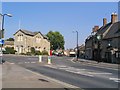
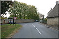
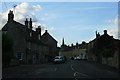
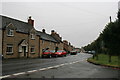
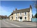
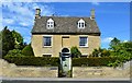
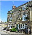
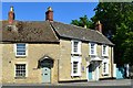
Photos of OX18 2NH


Area Information
Living in OX18 2NH means residing in a very compact residential cluster defined by the single postcode area. This location encompasses just over four acres, covering an area size of 9,415 m², which creates an intimate and closely knit community feel. With a population of 1,732 residents, the density is manageable at 166 people per square kilometre, ensuring a quiet atmosphere without the congestion of larger urban hubs. The small geographical footprint results in neighbours who likely know one another well, fostering a distinct sense of locality that defines daily life here. The setting is tailored for those seeking a rural or semi-rural lifestyle with minimal travel to essentials, as the cluster is self-contained in its design. Prospective buyers will find this postcode attractive for its simplicity and lack of urban sprawl. It represents a specific slice of Oxfordshire where the pace of life remains slow and deliberate, far removed from the noise of major cities. The compact nature of the neighbourhood means that most daily activities can be managed locally, reducing the need for frequent long-distance commuting. This balanced combination of space and community makes it a practical choice for families and individuals who value a stable, low-density environment.
- Area Type
- Postcode
- Area Size
- 9415 m²
- Population
- 1732
- Population Density
- 166 people/km²
The property market in OX18 2NH is characterised by a strong bias towards owner-occupied homes rather than rental properties. With 80% of households owning their residences, the area functions as a market for buyers looking to settle down rather than a hub for rental yields. The accommodation type is exclusively houses, ensuring that you can find standalone properties with gardens rather than shared flats or terraced apartment blocks. This homogeneity means that buyers can expect consistency in the style and setting of the homes they encounter during viewings. The small total population of 1,732 limits the volume of listings available at any one time, suggesting a niche market where properties sell quickly among local and nearby buyers. There are no large developments or uniform housing estates; instead, the housing stock likely comprises a mix of semi-dwellings and possibly detached homes typical of small rural clusters. For investors, this high ownership rate suggests lower turnover, which can be a double-edged sword regarding quick resale opportunities. However, for owner-occupiers, owning a house in this postcode offers the security of knowing the community is built around families who have put down roots. The lack of private rental stock also means fewer short-term lettings, which preserves the quiet residential nature of the neighbourhood.
House Prices in OX18 2NH
Showing 18 properties
| Address | Type | Beds | Baths | Last Sale Price | Last Sale Date | |
|---|---|---|---|---|---|---|
| 13 Fox Close, Bampton, OX18 2NH | Terraced | 2 | 1 | £325,000 | Jan 2025 | |
| 3 Fox Close, Bampton, OX18 2NH | house | - | - | £190,000 | Dec 2009 | |
| 4 Fox Close, Bampton, OX18 2NH | Semi-detached | - | - | £185,850 | Dec 2003 | |
| 10 Fox Close, Bampton, OX18 2NH | Terraced | 3 | 1 | £95,000 | Apr 2003 | |
| 5 Fox Close, Bampton, OX18 2NH | Semi-detached | - | - | £75,000 | Aug 1999 | |
| 6 Fox Close, Bampton, OX18 2NH | Semi-detached | - | - | £76,000 | Oct 1997 | |
| 2 Fox Close, Bampton, OX18 2NH | Semi-detached | - | - | £69,995 | Mar 1997 | |
| 1 Fox Close, Bampton, OX18 2NH | Semi-detached | - | - | - | - | |
| 16 Fox Close, Bampton, OX18 2NH | Terraced | - | - | - | - | |
| 7 Fox Close, Bampton, OX18 2NH | Terraced | - | - | - | - |
Energy Efficiency in OX18 2NH
Daily life in OX18 2NH offers convenient access to local retail and major transport hubs, blending rural tranquility with practical amenities. Residents benefit from five key retail venues within practical reach, including Co-op Bampton, Budgens Brize, and Morrisons Carterton. These supermarkets and convenience stores provide everything from weekly groceries to pharmacy services without requiring a long drive to Oxford city centre. A notable feature is the proximity to RAF Brize Norton, the single airport in the area, which serves as a critical transport link via its military aerodrome. While not a commercial passenger airport, its presence signals the area's connectivity to the wider transport network. The combination of local shops and near access to a major base means that residents can enjoy a self-contained lifestyle while remaining close to national travel routes. Dining options are likely limited to local takeaways or small venues, so planning meals via the nearby supermarkets is common. The layout ensures that errands are quick and manageable, fitting the slower pace of life preferred by the 47-year-old median resident.
Amenities
Schools
Families living in OX18 2NH have access to specific educational facilities within practical reach, though options are limited within the immediate coastal cluster. The primary nearby institution is the West Oxfordshire Pupil Referral Unit, which serves as an alternative education provider for students with specific needs. This facility is classified as an 'other' type of school rather than a standard primary or secondary academy. The presence of a Pupil Referral Unit indicates that the wider OX18 2NH region is connected to the broader educational network of West Oxfordshire, ensuring support for young learners who require non-traditional schooling. While there are no mainstream primary or secondary schools directly scoring data in this specific postcode snippet, the existence of the Pupil Referral Unit highlights the area's integration into the formal education system. Parents should research nearby mainstream institutions in the wider Bampton and Bulkeley catchment areas to find standard primary and secondary education. The addressing of the West Oxfordshire Pupil Referral Unit confirms that the area does not operate in isolation but is part of a larger county-wide educational framework. This connection ensures that children from OX18 2NH have access to broadened learning opportunities beyond their immediate street.
| Rank | School | Type | Entry gender | Ages |
|---|
Explore more schools in this area
Go to Schools tabDemographics
The community within OX18 2NH reflects a mature population, with a median age of 47 years. Most residents fall within the adults age range of 30 to 64 years, indicating a demographic dominated by established professionals and families. This age profile suggests a neighbourhood where residents have settled down and are likely focused on stability rather than transient living. Home ownership stands at 80%, meaning the vast majority of occupants buy their homes rather than rent. This high level of ownership typically correlates with greater investment in properties and a commitment to the local area. The predominant ethnic group is White, which aligns with the character of many rural Oxfordshire settlements. Housing in this postcode consists primarily of houses, offering the space and garden access that households with older children or retirees often prefer. There are no large blocks of flats or high-density apartments in this specific cluster. The demographic stability is further evidenced by the fact that long-term residents form the core of the local social fabric. This combination of older age, high ownership, and family-sized homes creates a predictable and low-conflict environment for those who move into the estate.
Household Size
Accommodation Type
Tenure
Ethnic Group
Religion
Household Composition
Age
Household Deprivation
NS-SEC
Explore more demographic insights in this area
Go to Demographics tabPlanning
Planning Constraints
- Flood RiskPremium
- Ramsar Wetland SitesPremium
- Area of Outstanding Natural BeautyPremium
- Protected Nature ReservePremium
- Protected WoodlandPremium