Area Overview for OX18 1NZ
Photos of OX18 1NZ

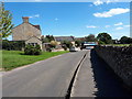
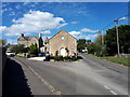
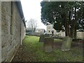
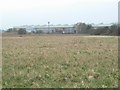
17 photos from this area
Area Information
Key information about the OX18 1NZ including its size, population, and administrative classification.
- Area Type
- Postcode
- Area Size
- 6.8 hectares
- Population
- 2406
- Population Density
- 334 people/km²
House Prices in OX18 1NZ
94
Properties
£434,383
Average Sold Price
£78,000
Lowest Price
£573,658
Highest Price
Showing 94 properties
| Address | Type | Beds | Baths | Last Sale Price | Last Sale Date | |
|---|---|---|---|---|---|---|
| 29 Miles Drive, Brize Norton, OX18 1NZ | Detached | 4 | 2 | £490,000 | Dec 2025 | |
| 50 Miles Drive, Brize Norton, OX18 1NZ | Detached | 4 | 3 | £510,000 | Aug 2025 | |
| 7 Miles Drive, Brize Norton, OX18 1NZ | Flat | - | - | £105,000 | Sep 2024 | |
| 65 Miles Drive, Brize Norton, OX18 1NZ | house | - | - | £465,000 | Apr 2024 | |
| 76 Miles Drive, Brize Norton, OX18 1NZ | house | - | - | £530,000 | Apr 2024 | |
| 70 Miles Drive, Brize Norton, OX18 1NZ | house | - | - | £505,000 | Apr 2024 | |
| 63 Miles Drive, Brize Norton, OX18 1NZ | Semi-detached | 3 | 2 | £370,000 | Mar 2024 | |
| 61 Miles Drive, Brize Norton, OX18 1NZ | house | - | - | £369,000 | Mar 2024 | |
| 3 Miles Drive, Brize Norton, OX18 1NZ | Flat | - | - | £78,000 | Mar 2024 | |
| 82 Miles Drive, Brize Norton, OX18 1NZ | house | - | - | £446,184 | Mar 2024 |
Page 1 of 10
Energy Efficiency in OX18 1NZ
Amenities
Schools
| Rank | School | Type | Entry gender | Ages |
|---|
Explore more schools in this area
Go to Schools tabDemographics
Household Size
Family (3-5 people)
most common
Accommodation Type
Houses
most common
Tenure
75
majority
Ethnic Group
White
most common
Religion
N/A
most common
Household Composition
N/A
most common
Age
22
median
Young Adults (15-29 years)
most common
Household Deprivation
N/A
with no deprivation
NS-SEC
44
in Lower managerial occupations
Explore more demographic insights in this area
Go to Demographics tabPlanning
Planning Constraints
- Flood RiskPremium
- Ramsar Wetland SitesPremium
- Area of Outstanding Natural BeautyPremium
- Protected Nature ReservePremium
- Protected WoodlandPremium