Area Overview for OX16 3HE
Photos of OX16 3HE


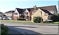
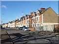
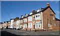
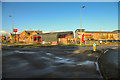
53 photos from this area
Area Information
Key information about the OX16 3HE including its size, population, and administrative classification.
- Area Type
- Postcode
- Area Size
- 3487 m²
- Population
- 1664
- Population Density
- 2527 people/km²
House Prices in OX16 3HE
18
Properties
£168,083
Average Sold Price
£53,500
Lowest Price
£275,000
Highest Price
Showing 18 properties
| Address | Type | Beds | Baths | Last Sale Price | Last Sale Date | |
|---|---|---|---|---|---|---|
| 92 West Street, Banbury, OX16 3HE | Terraced | 3 | 2 | £230,000 | Oct 2024 | |
| 102 West Street, Banbury, OX16 3HE | house | 3 | - | £173,000 | Dec 2020 | |
| 98 West Street, Banbury, OX16 3HE | Terraced | 3 | 1 | £240,000 | Oct 2020 | |
| 100 West Street, Banbury, OX16 3HE | Detached | 3 | 1 | £275,000 | Sep 2020 | |
| 151 West Street, Banbury, OX16 3HE | Semi-detached | 2 | 1 | £225,000 | Jul 2020 | |
| 96 West Street, Banbury, OX16 3HE | house | - | - | £202,000 | Jul 2018 | |
| 147 West Street, Banbury, OX16 3HE | Semi-detached | 3 | - | £170,000 | Jul 2008 | |
| 104 West Street, Banbury, OX16 3HE | Terraced | 2 | 1 | £155,500 | Sep 2007 | |
| 90 West Street, Banbury, OX16 3HE | Terraced | - | - | £128,500 | Dec 2004 | |
| 141 West Street, Banbury, OX16 3HE | Semi-detached | - | - | £101,000 | Mar 2001 |
Page 1 of 2
Energy Efficiency in OX16 3HE
Amenities
Schools
| Rank | School | Type | Entry gender | Ages |
|---|
Explore more schools in this area
Go to Schools tabDemographics
Household Size
One person
most common
Accommodation Type
Houses
most common
Tenure
48
majority
Ethnic Group
White
most common
Religion
N/A
most common
Household Composition
N/A
most common
Age
47
median
Adults (30-64 years)
most common
Household Deprivation
N/A
with no deprivation
NS-SEC
26
in Lower managerial occupations
Explore more demographic insights in this area
Go to Demographics tabPlanning
Planning Constraints
- Flood RiskPremium
- Ramsar Wetland SitesPremium
- Area of Outstanding Natural BeautyPremium
- Protected Nature ReservePremium
- Protected WoodlandPremium