Area Overview for OX11 0EN
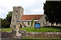
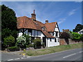
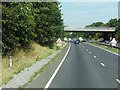
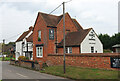
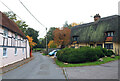
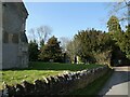
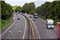
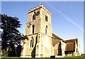
Photos of OX11 0EN


Area Information
OX11 0EN represents a specific residential cluster in Oxfordshire, covering a modest footprint of 2.8 hectares. You are looking at a self-contained community with a population of 1,306, meaning the area offers a tight-knit character without the chaos of a major urban centre. The housing density stands at 1,085 people per square kilometre, creating a setting that feels manageable yet established. This postcode is no outlier in terms of planning; it lacks any Ramsar wetland sites, Areas of Outstanding Natural Beauty status, or protected nature reserves within its bounds. Consequently, residents face minimal planning constraints regarding environmental protection. The simplicity of the location allows for straightforward daily commutes, supported by strong digital infrastructure. With fixed broadband quality scoring 89 out of 100 and mobile coverage at 81 out of 100, you can expect reliable connectivity for remote work or streaming. The area avoids high flood risk coverage entirely, ensuring safety from water-related threats. Living in OX11 0EN offers a practical balance between quiet residential life and access to essential services. You get a neighbourhood defined by house ownership and stability rather than transient rental trends.
- Area Type
- Postcode
- Area Size
- 2.8 hectares
- Population
- 1306
- Population Density
- 1085 people/km²
The housing market in OX11 0EN skews heavily towards owner-occupiers, with 66% of residents owning their homes outright or with a mortgage. This statistic signals a stable estate where investment properties for short-term letting are rare. Accommodation types consist primarily of houses, which fits the demographic profile of adults aged 30 to 64 preferentially choosing standalone or semi-detached properties. You will find very few apartments or flats within this 2.8-hectare cluster, making it an exclusive zone for those seeking traditional living spaces. The predominance of house ownership often correlates with higher price points per square metre compared to city centres, reflecting the value placed on space and quiet. For someone buying homes in OX11 0EN, the market offers limited inventory due to the small postcode size, so competition may push prices up during certain seasons. The lack of rental volatility suggests a predictable market environment. Whether you are looking to expand or downsize, you are joining a community where property values have typically shown resilience. The concentration of home ownership also means you are less likely to encounter difficult landlord-tenant relationships or sudden displacement issues common in high-turnover locations.
House Prices in OX11 0EN
Showing 7 properties
| Address | Type | Beds | Baths | Last Sale Price | Last Sale Date | |
|---|---|---|---|---|---|---|
| Broad Acres, The Cleave, Harwell, Didcot, OX11 0EN | Bungalow | 4 | 2 | £475,000 | May 2017 | |
| Crossfields, The Cleave, Harwell, Didcot, OX11 0EN | house | 4 | - | £200,000 | Jun 2010 | |
| Brookview, The Cleave, Harwell, Didcot, OX11 0EN | Detached | 4 | 2 | £320,000 | Jun 2001 | |
| School View, The Cleave, Harwell, Didcot, OX11 0EN | Bungalow | 4 | 1 | - | - | |
| 2, Brook Farm Cottages, The Cleave, Harwell, Didcot, OX11 0EN | Cottage | 2 | 1 | - | - | |
| 1, Brook Farm Cottages, The Cleave, Harwell, Didcot, OX11 0EN | Semi-detached | - | - | - | - | |
| Cemetery, Church Lane, Harwell, Didcot, OX11 0EN | commercial | - | - | - | - |
Energy Efficiency in OX11 0EN
Your daily life in OX11 0EN is shaped by convenient access to five key retail outlets located within practical reach. Asda Didcot, Sainsburys Didcot, and Morrisons Daily anchor the local commercial landscape, ensuring you can shop for groceries and household items without a long commute. The area also benefits from proximity to three railway stations: Didcot Parkway Railway Station, Appleford Railway Station, and Culham Railway Station. These transport nodes connect you to broader networks, reducing reliance on private vehicles for occasional trips. While the 2.8-hectare area itself is purely residential, the surrounding 1085 people per square kilometre density ensures a supportive network of neighbours. You will find that the nearest amenities are fewer than in large cities, but they are sufficient for weekly errands. The absence of heavy industry or major commercial developments nearby maintains a peaceful environment. The fixed broadband quality score of 89 indicates that digital entertainment and education options for your family are robust. When you visit OX11 0EN, you see a neighbourhood designed for efficiency and quiet, relying on high-quality services just outside the immediate boundary.
Amenities
Schools
| Rank | School | Type | Entry gender | Ages |
|---|
Explore more schools in this area
Go to Schools tabDemographics
The community within OX11 0EN is defined by stability and maturity. The median age here is 47, placing the most common age range firmly within adults aged 30 to 64 years. This demographic profile suggests a population that has put down roots, contrasting sharply with areas dominated by students or young professionals. Home ownership stands at a robust 66%, indicating that the majority of residents hold the title to their property. These households predominantly live in houses rather than apartments or flats, reinforcing the family-oriented nature of the neighbourhood. The predominant ethnic group is White, which aligns with the traditional character of many Oxfordshire villages. There is no data on specific deprivation indices in the provided information, so assessments of local economic hardship remain beyond our current scope. However, the high rate of ownership implies financial security among residents. The low population density of 1,085 people per square kilometre further supports the idea of spacious living. When you consider who lives in OX11 0EN, you are entering an environment where long-term settlement is the norm. The age structure and ownership rates create a quiet, settled atmosphere that attracts families seeking consistency.
Household Size
Accommodation Type
Tenure
Ethnic Group
Religion
Household Composition
Age
Household Deprivation
NS-SEC
Explore more demographic insights in this area
Go to Demographics tabPlanning
Planning Constraints
- Flood RiskPremium
- Ramsar Wetland SitesPremium
- Area of Outstanding Natural BeautyPremium
- Protected Nature ReservePremium
- Protected WoodlandPremium