Area Overview for OX10 7AU
Photos of OX10 7AU
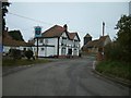
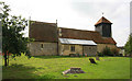
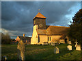

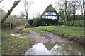
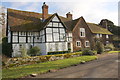
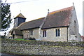

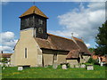
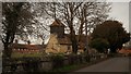
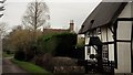
86 photos from this area
Area Information
Key information about the OX10 7AU including its size, population, and administrative classification.
- Area Type
- Postcode
- Area Size
- 1.5 hectares
- Population
- 1369
- Population Density
- 61 people/km²
House Prices in OX10 7AU
11
Properties
£490,667
Average Sold Price
£355,000
Lowest Price
£750,000
Highest Price
Showing 11 properties
| Address | Type | Beds | Baths | Last Sale Price | Last Sale Date | |
|---|---|---|---|---|---|---|
| Briar Rose House, Church Lane, Drayton St Leonard, Wallingford, OX10 7AU | Detached | 4 | 1 | £750,000 | May 2024 | |
| The Old School House, Church Lane, Drayton St Leonard, Wallingford, OX10 7AU | Detached | 2 | 1 | £367,000 | May 2021 | |
| Spring Cottage, Church Lane, Drayton St Leonard, Wallingford, OX10 7AU | Semi-detached | - | - | £355,000 | Sep 2014 | |
| The Old Rectory, Church Lane, Drayton St Leonard, Wallingford, OX10 7AU | Detached | 8 | - | - | - | |
| The Flat, Furlongs, Church Lane, Drayton St Leonard, Wallingford, OX10 7AU | Detached | 8 | 4 | - | - | |
| The Hollies, Church Lane, Drayton St Leonard, Wallingford, OX10 7AU | Semi-detached | - | - | - | - | |
| Three Pigeons, Church Lane, Drayton St Leonard, Wallingford, OX10 7AU | Detached | - | - | - | - | |
| Red Kite House, Church Lane, Drayton St Leonard, Wallingford, OX10 7AU | house | - | - | - | - | |
| The Old Rectory Coach House, Church Lane, Drayton St Leonard, Wallingford, OX10 7AU | house | - | - | - | - | |
| Graveyard, St Leonards Church, Church Lane, Drayton St Leonard, Wallingford, OX10 7AU | commercial | - | - | - | - |
Page 1 of 2
Energy Efficiency in OX10 7AU
Amenities
Schools
| Rank | School | Type | Entry gender | Ages |
|---|
Explore more schools in this area
Go to Schools tabDemographics
Household Size
Family (3-5 people)
most common
Accommodation Type
Houses
most common
Tenure
75
majority
Ethnic Group
White
most common
Religion
N/A
most common
Household Composition
N/A
most common
Age
47
median
Adults (30-64 years)
most common
Household Deprivation
N/A
with no deprivation
NS-SEC
48
in Lower managerial occupations
Explore more demographic insights in this area
Go to Demographics tabPlanning
Planning Constraints
- Flood RiskPremium
- Ramsar Wetland SitesPremium
- Area of Outstanding Natural BeautyPremium
- Protected Nature ReservePremium
- Protected WoodlandPremium