Area Overview for OX1 4PF
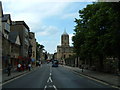
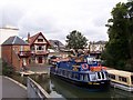
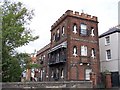
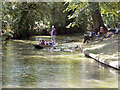
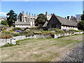
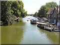
Photos of OX1 4PF


Area Information
OX1 4PF is a specific postcode area covering a small residential cluster within Oxford. It has a population of 1148, creating a tightly knit community where neighbours often know one another. This compact size means you are dealing with a defined neighbourhood rather than a sprawling district. The area is situated in England, offering a slice of life that balances proximity to the city with the quiet of a smaller settlement. When you live in OX1 4PF, you gain access to the wider opportunities of Oxford while retaining a sense of local stability. The demographic profile suggests a mature community, which often results in well-maintained properties and a steady, established atmosphere. You should expect a residential environment focused on family life and long-term accommodation rather than transient movement. The area functions as a logical extension of Oxford, connecting residents to the city centre through reliable transport links. Daily life here revolves around practical convenience, with key services located at manageable distances. This postcode represents a strategic choice for those seeking a home on the edge of the city, combining access to urban amenities with a more settled pace of living.
- Area Type
- Postcode
- Area Size
- Not available
- Population
- 1148
- Population Density
- 4742 people/km²
The housing stock in OX1 4PF is characterised by houses, which form the primary accommodation type in this postcode. With 55% of residents being homeowners, the area leans heavily towards owner-occupied housing rather than the rental sector. This statistic implies that when you buy a home in OX1 4PF, you are entering a market of long-term residents who likely value the location. The small population of 1148 means there are a limited number of available properties, making each individual house significant to the local stock. There are no high-rise blocks or luxury flats typical of city centre living here. Instead, the market offers traditional residential spaces suited for families and established households. The high ownership rate suggests stability, as these residents are less likely to move frequently. If you are looking to add value or gain equity, this environment of stability can be beneficial compared to volatile rental markets. Understanding this mix helps you frame your expectations regarding property maintenance and neighbour engagement. The local market operates on the principles of a specialist residential suburb rather than a broad investment hotspot.
House Prices in OX1 4PF
No properties found in this postcode.
Energy Efficiency in OX1 4PF
Residents of OX1 4PF enjoy access to numerous shops and transport hubs within practical reach. Your daily shopping routine can be managed with nearby Tesco Oxford, Sainsburys Oxford, and M&S Oxford. These three major retailers are listed as notable amenities, ensuring you have full access to grocery and clothing needs without travelling far. For travel, you are supported by four railway stations nearby, including Radley Railway Station, Oxford Parkway Railway Station, and Islip Railway Station. This rail infrastructure provides multiple options for commuting into Oxford or joining leisure trips. The presence of large national chains alongside local rail access creates a functional lifestyle balance. You can fuel up at Sainsburys Oxford before heading to a destination served by Radley Railway Station. This combination of retail convenience and transport variety defines the local character. There are no indoor marketplaces or cinemas listed in the immediate vicinity, so planning for evening entertainment or dining out involves a short drive to Oxford city centre.
Amenities
Schools
| Rank | School | Type | Entry gender | Ages |
|---|
Explore more schools in this area
Go to Schools tabDemographics
The community in OX1 4PF is defined by a stable age structure, with a median age of 47. Adults aged between 30 and 64 years represent the most common age range in the area. This detail confirms that the neighbourhood is dominated by homeowners and families in their prime working years. You are unlikely to encounter a demographic heavy with students or elderly retirees compared to other Oxford zones. There is a high rate of home ownership, with 55% of residents owning their properties outright or with a mortgage. Considering the compact population of 1148, this indicates that investment and stability are central themes for local residents. The primary accommodation type is houses, meaning you will predominantly find detached or semi-detached properties rather than apartment blocks. The predominant ethnic group is White, reflecting a demographic composition consistent with many established suburbs in Oxfordshire. Living in OX1 4PF means joining a community where families may have lived for decades. The age and ownership profiles suggest a quiet, predictable environment where changing your address is a significant life event rather than a frequent occurrence.
Household Size
Accommodation Type
Tenure
Ethnic Group
Religion
Household Composition
Age
Household Deprivation
NS-SEC
Explore more demographic insights in this area
Go to Demographics tabPlanning
Planning Constraints
- Flood RiskPremium
- Ramsar Wetland SitesPremium
- Area of Outstanding Natural BeautyPremium
- Protected Nature ReservePremium
- Protected WoodlandPremium