Area Overview for Nutfield
Photos of Nutfield
Area Information
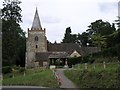
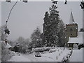
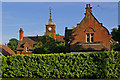
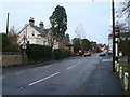
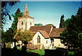
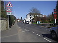
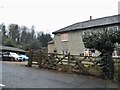
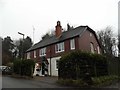
Living in Nutfield offers a compact, well-defined community within a 22.5-hectare built-up area. The area’s older demographic, with a median age of 70, suggests a mature population, likely drawn to its established housing stock and proximity to transport links. Nutfield sits at the edge of a broader network of towns, with nearby railway stations and Gatwick Airport just a short distance away. Daily life here is characterised by a mix of local retail, including Spar, Tesco Redhill, and Co-op Merstham, and easy access to rail services. The area’s appeal lies in its balance of quiet living with practical connectivity, making it suitable for those seeking a settled environment without sacrificing convenience. With 79% of homes owner-occupied, Nutfield is a place where long-term residents predominate, contributing to a sense of continuity. For buyers, the area presents a mix of established properties in a setting that prioritises accessibility over rapid change.
- Area Type
- Built Up Area 250
- Area Size
- 22.5 hectares
- Population
- Not available
- Population Density
- Not available
Nutfield’s lifestyle is shaped by its proximity to essential amenities. Local shops such as Spar, Tesco Redhill, and Co-op Merstham provide everyday convenience, while five railway stations and two Gatwick shuttle stations offer seamless travel options. The area’s connection to London Gatwick Airport adds to its appeal for those needing regular air travel. For leisure, the surrounding towns likely offer parks and recreational spaces, though specific details are not included. The mix of retail, transport, and airport access creates a practical, accessible environment, ideal for those prioritising connectivity over sprawling urban amenities.
Amenities
Schools
The nearest school to Nutfield is Doods Brow School, an independent institution. Independent schools are fee-paying, which may be relevant for families considering educational options. While no Ofsted rating is provided, the presence of an independent school indicates a range of educational choices for residents. However, the data does not include state schools or their performance, so families should investigate further if they require free education. The mix of school types in the area is limited, with only one named institution listed, meaning prospective residents may need to look beyond Nutfield for a broader selection of schools.
| Rank | School | Type | Entry gender | Ages |
|---|
Explore more schools in this area
Go to Schools tabDemographics
Nutfield’s population is predominantly older, with a median age of 70, reflecting a community where retirees or long-term residents form the majority. The home ownership rate is 79%, indicating a strong presence of owner-occupied properties. The data does not specify household composition or ethnic diversity, but the high home ownership suggests a stable, settled population. The area’s age profile may influence local services and amenities, with a focus on accessibility and community support. While no specific deprivation data is provided, the high home ownership and low crime risk suggest a relatively secure, self-sufficient community. However, the lack of detailed demographic breakdowns means broader social dynamics remain less defined.
Household Size
Accommodation Type
Tenure
Ethnic Group
Religion
Household Composition
Age
Household Deprivation
NS-SEC
Explore more demographic insights in this area
Go to Demographics tabPlanning
Planning Constraints
- Crime RiskPremium