Area Overview for MK9 1EF
Photos of MK9 1EF


Area Information
MK9 1EF is a small, densely populated residential postcode area in England, home to 1,470 people spread across 1.33 square kilometres. This compact cluster of homes is characterised by its high population density of 1,116 people per square kilometre, suggesting a tightly knit community. The area’s proximity to Milton Keynes, a major urban hub, offers residents access to a range of services, though its own footprint remains modest. Daily life here is shaped by the surrounding infrastructure, with nearby railway stations and retail outlets within practical reach. The area’s demographic profile, dominated by adults aged 30–64, hints at a mature population with established routines. While the data does not specify local employment patterns, the presence of multiple railway stations suggests connectivity to broader economic opportunities. For those considering living in MK9 1EF, the balance of space, community density, and access to transport and amenities makes it a pragmatic choice for those prioritising convenience over expansive living environments.
- Area Type
- Postcode
- Area Size
- Not available
- Population
- 1470
- Population Density
- 1116 people/km²
The property market in MK9 1EF is defined by its low home ownership rate of 25%, which implies that the majority of housing is rented rather than owned. This suggests a rental-dominated market, possibly influenced by the area’s compact size and the prevalence of flats. Flats are the primary accommodation type, which may reflect the need for space-efficient living in a densely populated area. For buyers, this dynamic could present challenges, as the limited availability of owner-occupied properties may reduce the pool of potential sellers. However, the concentration of flats might also indicate a demand for affordable, manageable housing, particularly for those seeking proximity to transport links and amenities. Buyers should consider the area’s small footprint and its role as part of a larger Milton Keynes network when evaluating long-term value or investment potential.
House Prices in MK9 1EF
No properties found in this postcode.
Energy Efficiency in MK9 1EF
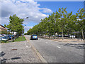
The lifestyle in MK9 1EF is shaped by its proximity to retail and transport hubs. Nearby amenities include Sainsburys Milton, Aldi The, and Morrisons Milton, offering a range of shopping and grocery options within easy reach. The area’s railway stations, such as Milton Keynes Central, provide access to broader leisure and cultural opportunities in the surrounding region. However, the data does not specify local parks or recreational facilities, meaning residents may need to travel slightly further for green spaces or leisure activities. The compact nature of the area fosters a sense of proximity to essential services, though the absence of detailed information on local amenities suggests a reliance on nearby towns for a fuller range of lifestyle options.
Amenities
Schools
Residents of MK9 1EF have access to two independent schools: Citischool and iPEC. Both institutions fall under the independent sector, which typically caters to families seeking alternative educational pathways outside the state system. The absence of state-funded schools in the immediate vicinity means families must consider commuting or enrolling their children in private institutions. This mix of school types may appeal to those prioritising specific educational philosophies or resources, though it also underscores the area’s limited range of formal schooling options. For families reliant on state education, proximity to other areas with comprehensive schools could be a factor in deciding whether MK9 1EF meets their needs.
| Rank | School | Type | Entry gender | Ages |
|---|---|---|---|---|
| 1 | Citischool | independent | N/A | N/A |
| 2 | iPEC | independent | N/A | N/A |
Explore more schools in this area
Go to Schools tabDemographics
The population of MK9 1EF skews heavily towards adults aged 30–64, with a median age of 47. This suggests a community of middle-aged residents, likely focused on stability and long-term settlement. Home ownership is relatively low at 25%, indicating that a majority of residents rent their accommodation. The predominant property type is flats, which aligns with the area’s high population density and compact layout. The predominant ethnic group is White, though no further breakdown of diversity is provided. The lack of specific data on deprivation or income levels means the area’s socioeconomic profile remains partially opaque. However, the high proportion of renters and the prevalence of flats may suggest a mix of transient and long-term residents, with potential implications for community cohesion and housing affordability.
Household Size
Accommodation Type
Tenure
Ethnic Group
Religion
Household Composition
Age
Household Deprivation
NS-SEC
Explore more demographic insights in this area
Go to Demographics tabPlanning
Planning Constraints
- Flood RiskPremium
- Ramsar Wetland SitesPremium
- Area of Outstanding Natural BeautyPremium
- Protected Nature ReservePremium
- Protected WoodlandPremium
- Crime RiskPremium