Area Overview for MK7 7AJ
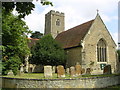
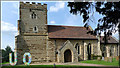
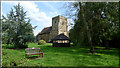
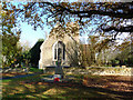
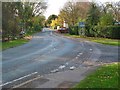
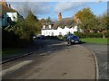
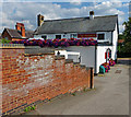
Photos of MK7 7AJ


Area Information
MK7 7AJ is a compact residential postcode in England, covering just 6.6 hectares and home to 1,973 people. Its population density of 1,124 people per square kilometre suggests a tightly knit community, with homes clustered closely together. The area’s small size means it is likely a quiet, low-traffic neighbourhood, ideal for those seeking a settled lifestyle. Daily life here is shaped by proximity to essential services, with five retail outlets within practical reach, including The Southern Co-operative and Tesco branches. The presence of multiple railway stations—Bow Brickhill, Fenny Stratford, and Bletchley—offers easy access to nearby towns and cities, while Cranfield Airport provides a direct link to regional travel. The area’s demographics, dominated by adults aged 30-64, suggest a mix of established families and professionals, with a median age of 47. This balance of stability and convenience makes MK7 7AJ a practical choice for homebuyers prioritising accessibility and community cohesion.
- Area Type
- Postcode
- Area Size
- 6.6 hectares
- Population
- 1973
- Population Density
- 1124 people/km²
MK7 7AJ’s property market is defined by its 57% home ownership rate, suggesting a majority of properties are owner-occupied rather than rented. The accommodation type is predominantly houses, which aligns with the area’s compact size and likely focus on family homes. Given the small area size of 6.6 hectares, the housing stock is likely limited, with properties closely spaced. This could mean a competitive market for buyers, particularly those seeking larger homes in a residential setting. The proximity to multiple railway stations and retail outlets may enhance the area’s appeal, though the lack of detailed property listings or price data means buyers must assess individual homes for value. The presence of schools and transport links suggests the area is attractive to families, but the small size may limit long-term growth or development. For buyers, the key considerations are the balance between property availability and the area’s practical advantages.
House Prices in MK7 7AJ
Showing 8 properties
Energy Efficiency in MK7 7AJ
Living in MK7 7AJ offers a blend of convenience and accessibility. The area is within practical reach of five retail outlets, including The Southern Co-operative and Tesco Tinkers, ensuring daily shopping needs are met. Rail stations such as Bow Brickhill and Fenny Stratford provide easy access to nearby towns, while Cranfield Airport offers regional travel options. The compact size of the postcode means amenities are closely clustered, reducing the need for long commutes. The presence of multiple schools, including Kents Hill Park all-through school, adds to the area’s appeal for families. While the data does not specify parks or leisure facilities, the proximity to railway stations and retail hubs suggests a lifestyle focused on practicality and connectivity. The area’s small footprint may limit large-scale leisure options, but its strategic location ensures residents can access broader opportunities beyond the immediate vicinity.
Amenities
Schools
MK7 7AJ is served by a range of educational institutions, including Kents Hill School, which operates as both a primary school and an academy, and Kents Hill Park all-through school, which holds a good Ofsted rating. Walton Pre-Prep School & Nursery is an independent option, while The Open University is listed as an ‘other’ type of educational provider. This mix of state-funded and independent schools offers families flexibility, with the all-through school providing continuity from early years to secondary education. The presence of multiple schools within the area suggests a strong focus on education, though the exact catchment areas or student numbers are not specified. For families prioritising school quality, the good rating at Kents Hill Park all-through school may be a key draw. However, the absence of detailed performance metrics or pupil demographics means further research is needed to assess the full range of educational opportunities.
| Rank | School | Type | Entry gender | Ages |
|---|
Explore more schools in this area
Go to Schools tabDemographics
The population of MK7 7AJ is predominantly adults aged 30-64, with a median age of 47. This suggests a mature, established community, likely with a strong presence of families and professionals. Home ownership stands at 57%, indicating a mix of owner-occupied properties and rentals, though the exact proportion of each is not specified. The area is characterised by houses rather than flats, reflecting a traditional housing stock suited to family living. The predominant ethnic group is White, though specific data on diversity or deprivation is not provided. The high population density—1,124 people per square kilometre—points to a compact, possibly mixed-use area where residential and commercial spaces coexist. This density may influence local amenities and social dynamics, though the data does not quantify levels of deprivation or socioeconomic variation. The absence of detailed diversity metrics means the community’s full demographic profile remains partially unexplored.
Household Size
Accommodation Type
Tenure
Ethnic Group
Religion
Household Composition
Age
Household Deprivation
NS-SEC
Explore more demographic insights in this area
Go to Demographics tabPlanning
Planning Constraints
- Flood RiskPremium
- Ramsar Wetland SitesPremium
- Area of Outstanding Natural BeautyPremium
- Protected Nature ReservePremium
- Protected WoodlandPremium