Area Overview for MK46 5LH
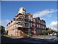
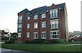
Photos of MK46 5LH


Area Information
MK46 5LH is a small, residential postcode area in England, home to 1,872 people spread across a compact cluster of homes. With a population density of 346 people per square kilometre, it reflects a tightly knit community where local interactions are likely frequent. The area is characterised by its focus on housing, with most properties being owner-occupied. This suggests a stable, long-term presence of residents, many of whom are in their 30s to 60s, as the median age here is 47. Daily life in MK46 5LH is shaped by proximity to essential services, including nearby retail hubs like Sainsburys in Olney and Tesco in the same town. While the area lacks large-scale infrastructure, its small size means residents can access amenities within short distances. The absence of significant environmental constraints, such as protected woodlands or Areas of Outstanding Natural Beauty, means development and living here is straightforward. For those seeking a quiet, family-oriented environment with low crime and flood risk, MK46 5LH offers a practical, low-maintenance lifestyle.
- Area Type
- Postcode
- Area Size
- Not available
- Population
- 1872
- Population Density
- 346 people/km²
The property market in MK46 5LH is dominated by owner-occupied homes, with 82% of residents living in their own properties. This high rate of home ownership suggests a stable market with limited rental activity, making it more attractive to buyers seeking long-term investment rather than short-term tenancy. The accommodation type is predominantly houses, which are typically larger and more suited to families or individuals requiring more space. Given the small size of the postcode area, the housing stock is likely limited, meaning buyers may need to consider nearby regions for more options. The absence of flats or apartments indicates a preference for traditional, standalone homes. For those prioritising property value retention and a low-risk environment, MK46 5LH’s market offers a reliable, if modest, range of properties. However, the limited scale of the area may restrict the variety of available homes.
House Prices in MK46 5LH
No properties found in this postcode.
Energy Efficiency in MK46 5LH
Residents of MK46 5LH have access to nearby retail amenities, including Aldi on Worcester Way, Sainsburys in Olney, and Tesco in the same town. These stores provide essential shopping options, from groceries to household goods, within practical reach. While the data does not mention parks or leisure facilities, the presence of multiple retail outlets suggests a convenience-focused lifestyle. The area’s small size means daily errands can be completed without long commutes. For those valuing self-sufficiency, the proximity to major supermarkets and local shops reduces the need for travel beyond the immediate vicinity. The lack of detailed information on other amenities means the lifestyle is primarily defined by retail accessibility, though the absence of environmental constraints may allow for future development of leisure spaces.
Amenities
Schools
| Rank | School | Type | Entry gender | Ages |
|---|
Explore more schools in this area
Go to Schools tabDemographics
The community in MK46 5LH is predominantly composed of adults aged 30 to 64, with a median age of 47. This suggests a mature population, likely with established careers and families. Home ownership is high, with 82% of residents living in their own homes, indicating a stable, long-term demographic. The area is almost exclusively made up of houses, not flats, which aligns with the profile of a suburban or semi-rural setting. The predominant ethnic group is White, reflecting a homogenous population. While no specific data on deprivation is provided, the high home ownership rate and low crime score of 82 imply a relatively affluent and secure environment. The absence of significant diversity data means the community’s social composition is likely uniform, though this does not necessarily indicate a lack of inclusivity. For residents, this demographic profile suggests a quiet, predictable lifestyle with minimal disruption.
Household Size
Accommodation Type
Tenure
Ethnic Group
Religion
Household Composition
Age
Household Deprivation
NS-SEC
Explore more demographic insights in this area
Go to Demographics tabPlanning
Planning Constraints
- Flood RiskPremium
- Ramsar Wetland SitesPremium
- Area of Outstanding Natural BeautyPremium
- Protected Nature ReservePremium
- Protected WoodlandPremium