Area Overview for MK2 2EA
Photos of MK2 2EA


Area Information
Living in MK2 2EA offers a compact, residential experience with a population of 2,252, making it a small but cohesive community. The area is defined by its proximity to local amenities and schools, catering to families and individuals seeking a balanced lifestyle. With a median age of 47, the population skews toward adults aged 30–64, suggesting a stable, established demographic. Daily life here is shaped by the availability of nearby schools, retail outlets, and rail connections, which provide practical access to larger towns. The area’s broadband score of 96 ensures reliable internet for both work and leisure, while mobile coverage of 85 supports connectivity on the move. However, residents should be mindful of the high crime risk, with a safety score of 18, which is above average. Despite this, the absence of environmental constraints like protected woodlands or AONB designations means development is not restricted. MK2 2EA is a practical choice for those prioritising accessibility to services and a quieter, residential environment.
- Area Type
- Postcode
- Area Size
- Not available
- Population
- 2252
- Population Density
- 5429 people/km²
The property market in MK2 2EA is defined by its 53% home ownership rate, which indicates a balance between owner-occupied homes and rental properties. The area is predominantly composed of houses, rather than flats or apartments, suggesting a focus on family-friendly, spacious living. This makes it an attractive option for buyers seeking traditional housing stock, though the small size of the postcode means the market is limited in scale. The proximity to rail stations and schools may enhance property values for those prioritising convenience. However, the high crime risk and lack of environmental constraints could influence perceptions of safety and desirability. Buyers should consider the area’s compact nature and its integration with nearby amenities, such as retail outlets in Bletchley, when evaluating long-term viability.
House Prices in MK2 2EA
No properties found in this postcode.
Energy Efficiency in MK2 2EA
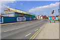
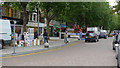
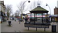
MK2 2EA’s lifestyle is shaped by its proximity to practical amenities, including retail outlets like Farmfoods Bletchley, Lidl Bletchley, and Iceland Bletchley, which cater to daily shopping needs. The area’s rail connections offer access to broader leisure and employment opportunities, with stations such as Bletchley providing links to cultural and commercial hubs. While there is no explicit mention of parks or recreational spaces in the data, the absence of environmental constraints like protected woodlands or AONB designations suggests that development prioritises accessibility over natural landscapes. The community’s character is defined by its compact size and integration with nearby services, offering a blend of convenience and residential tranquillity.
Amenities
Schools
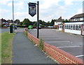
MK2 2EA is served by a comprehensive range of schools, including Knowles Nursery School, Knowles Infant School, Knowles Junior School, and Knowles Primary School. One of the primary schools holds an Ofsted rating of ‘good’, reflecting a standard of education that meets regulatory benchmarks. The presence of multiple schools catering to different age groups ensures families have options for early years education, primary schooling, and continuity in their children’s learning. This density of educational facilities is a key advantage for families, reducing the need for long commutes. The schools’ proximity to homes in the area also supports a community-oriented approach to education, with local amenities and transport links facilitating daily school runs.
| Rank | School | Type | Entry gender | Ages |
|---|
Explore more schools in this area
Go to Schools tabDemographics
MK2 2EA’s population of 2,252 is predominantly composed of adults aged 30–64, with a median age of 47. This suggests a mature, settled community with a focus on family living. Home ownership stands at 53%, indicating a mix of owner-occupied properties and rental stock. The area is characterised by houses rather than flats, reflecting a preference for traditional, spacious accommodation. The predominant ethnic group is White, though no specific data on diversity or deprivation is provided. The age profile implies a population that is likely employed in local or regional roles, with fewer young families or retirees compared to other areas. For buyers, this demographic suggests a community with established routines and a demand for stable, long-term housing. The absence of specific deprivation metrics means quality of life assessments must rely on the available infrastructure and services.
Household Size
Accommodation Type
Tenure
Ethnic Group
Religion
Household Composition
Age
Household Deprivation
NS-SEC
Explore more demographic insights in this area
Go to Demographics tabPlanning
Planning Constraints
- Flood RiskPremium
- Ramsar Wetland SitesPremium
- Area of Outstanding Natural BeautyPremium
- Protected Nature ReservePremium
- Protected WoodlandPremium