Area Overview for MK18 4AW
Photos of MK18 4AW
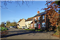
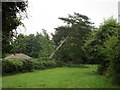


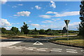
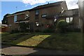
22 photos from this area
Area Information
Key information about the MK18 4AW including its size, population, and administrative classification.
- Area Type
- Postcode
- Area Size
- 3.5 hectares
- Population
- 1299
- Population Density
- 37 people/km²
House Prices in MK18 4AW
20
Properties
£248,656
Average Sold Price
£121,300
Lowest Price
£427,000
Highest Price
Showing 20 properties
| Address | Type | Beds | Baths | Last Sale Price | Last Sale Date | |
|---|---|---|---|---|---|---|
| Wyndham Rose, Mere Road, Finmere, MK18 4AW | Detached | 3 | 3 | £427,000 | Dec 2017 | |
| Lark Rise, Mere Road, Finmere, MK18 4AW | Bungalow | 3 | - | £197,500 | Mar 2013 | |
| Plum Tree Cottage, Mere Road, Finmere, MK18 4AW | house | - | - | £290,000 | Jun 2010 | |
| Copperstones, Mere Road, Finmere, MK18 4AW | Detached | 4 | 3 | £317,500 | Jul 2007 | |
| Coniston, Mere Road, Finmere, MK18 4AW | Detached | - | - | £250,000 | Apr 2002 | |
| The Bears, Mere Road, Finmere, MK18 4AW | Detached | - | - | £249,950 | Jun 2001 | |
| Teversal, Mere Road, Finmere, MK18 4AW | Semi-detached | - | - | £136,000 | Feb 1999 | |
| Hawthorne Cottage, Mere Road, Finmere, MK18 4AW | Detached | - | - | £121,300 | Apr 1997 | |
| The Brambles, Mere Road, Finmere, MK18 4AW | Detached | 4 | 2 | - | - | |
| Lark Rise Caravan, Mere Road, Finmere, MK18 4AW | Mobile Home | - | - | - | - |
Page 1 of 2
Energy Efficiency in MK18 4AW
Amenities
Schools
| Rank | School | Type | Entry gender | Ages |
|---|
Explore more schools in this area
Go to Schools tabDemographics
Household Size
Two person
most common
Accommodation Type
Houses
most common
Tenure
76
majority
Ethnic Group
White
most common
Religion
N/A
most common
Household Composition
N/A
most common
Age
47
median
Adults (30-64 years)
most common
Household Deprivation
N/A
with no deprivation
NS-SEC
47
in Lower managerial occupations
Explore more demographic insights in this area
Go to Demographics tabPlanning
Planning Constraints
- Flood RiskPremium
- Ramsar Wetland SitesPremium
- Area of Outstanding Natural BeautyPremium
- Protected Nature ReservePremium
- Protected WoodlandPremium