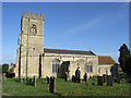
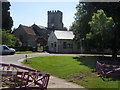
Area Overview for MK18 2PJ
Photos of MK18 2PJ


Area Information
Living in MK18 2PJ offers a quiet, low-density residential experience. With a population of 1,609 spread across 64 people per square kilometre, this small postcode area feels uncluttered, ideal for those seeking a slower pace of life. The area’s compact size means it is likely nestled within a larger town or village, with proximity to nearby centres like Buckingham providing access to broader amenities. Residents here are predominantly adults aged 30–64, with a median age of 47, suggesting a mature, stable community. The high rate of home ownership—85%—indicates a focus on long-term residency rather than transient rental markets. Daily life is shaped by the availability of nearby schools, retail outlets, and the area’s low environmental risk factors. While the postcode itself is small, its surroundings likely offer a mix of rural tranquillity and commuter convenience, making it a practical choice for families or professionals seeking balance between seclusion and accessibility.
- Area Type
- Postcode
- Area Size
- Not available
- Population
- 1609
- Population Density
- 64 people/km²
The property market in MK18 2PJ is dominated by owner-occupied homes, with 85% of properties owned outright. This high rate of home ownership suggests a community prioritising stability over rental flexibility, which is typical of areas with a mature population. The accommodation type is exclusively houses, indicating a lack of flats or apartments. This makes the area more suited to families or individuals seeking space and privacy, rather than urban renters. Given the postcode’s small size, the housing stock is limited, meaning buyers may need to consider nearby areas for more options. The presence of houses also implies potential for larger gardens or outdoor spaces, which could be a draw for those valuing property with land. However, the limited scale of MK18 2PJ means the market is unlikely to offer a wide variety of property types or price points.
House Prices in MK18 2PJ
No properties found in this postcode.
Energy Efficiency in MK18 2PJ
The lifestyle in MK18 2PJ is shaped by its proximity to retail and everyday amenities. Within practical reach, residents can access five notable retail outlets, including Lidl on London Road, Tesco in Buckingham, and M&S at Buckingham BP. These shops provide a range of essentials, from groceries to household goods, reducing the need for long trips to larger centres. While the area does not list parks or leisure facilities in its data, its small size suggests it may be integrated into a larger town or village with more extensive amenities. The presence of multiple retail options indicates a focus on convenience, catering to daily needs without requiring significant travel. For those valuing self-sufficiency, the nearby shops and likely access to nearby towns like Buckingham offer a practical balance between local convenience and broader choices.
Amenities
Schools
Residents of MK18 2PJ have access to two primary schools within practical reach. Thornborough Infant School is rated ‘good’ by Ofsted, offering a solid foundation for younger children. Whaddon CofE School, also a primary institution, has a ‘satisfactory’ rating, indicating room for improvement in certain areas. The presence of two primary schools suggests a focus on early education, though families requiring secondary schooling may need to look further afield. The mix of school types—both state and church-affiliated—provides some choice, though the data does not specify the quality of secondary options nearby. For parents prioritising primary education, the availability of two schools within the area offers convenience, though the varying Ofsted ratings mean careful consideration of each institution’s strengths is advisable.
| Rank | School | Type | Entry gender | Ages |
|---|
Explore more schools in this area
Go to Schools tabDemographics
MK18 2PJ is characterised by a mature population, with a median age of 47 and the majority of residents falling within the 30–64 age range. This suggests a community of established professionals and families, rather than a younger, student-dominated area. Home ownership is exceptionally high at 85%, reflecting a preference for long-term investment in property. The accommodation type is predominantly houses, which aligns with the area’s lower density and likely suburban or semi-rural setting. The predominant ethnic group is White, which is consistent with broader regional trends in England. While the data does not specify deprivation levels, the combination of high home ownership and a stable age profile implies a relatively affluent or middle-income demographic. This profile may influence local services and amenities, with a focus on family-oriented infrastructure such as primary schools and retail hubs.
Household Size
Accommodation Type
Tenure
Ethnic Group
Religion
Household Composition
Age
Household Deprivation
NS-SEC
Explore more demographic insights in this area
Go to Demographics tabPlanning
Planning Constraints
- Flood RiskPremium
- Ramsar Wetland SitesPremium
- Area of Outstanding Natural BeautyPremium
- Protected Nature ReservePremium
- Protected WoodlandPremium