Area Overview for MK18 1AA
Photos of MK18 1AA


Area Information
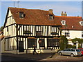
Living in MK18 1AA means being part of a compact, densely populated residential cluster in England. The area spans 764 square metres and is home to 1,432 residents, making it a tightly knit community with a population density of over 1.8 million people per square kilometre. This postcode is positioned near Buckingham, offering proximity to both urban and semi-rural settings. Daily life here is shaped by its small size and limited expansion, with residents relying on nearby towns for broader amenities. The area’s character is defined by its mix of older housing stock and proximity to local institutions such as the University of Buckingham. While the community is small, it is served by essential services, including retail hubs and a nearby airport. For those seeking a quiet, established neighbourhood with practical access to nearby towns, MK18 1AA provides a focused, self-contained living environment. However, its size means that any changes to local infrastructure or services will have a direct impact on residents.
- Area Type
- Postcode
- Area Size
- 764 m²
- Population
- 1432
- Population Density
- 4291 people/km²
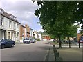
The property market in MK18 1AA is defined by its small size and limited housing stock. With 33% of residents owning their homes, the area is not a major hub for owner-occupation but may appeal to those seeking a quieter, established neighbourhood. The predominant accommodation type is houses, which suggests that the area is more suited to families or individuals preferring detached or semi-detached properties. Given the postcode’s compact nature, the housing stock is unlikely to be extensive, which could limit availability for buyers. Those considering the area should note that it is not a rental market hotspot, as the data does not highlight a significant presence of rental properties. The small size of MK18 1AA means that property values and availability are likely influenced by nearby towns such as Buckingham. Buyers should also consider the area’s proximity to local amenities, which may offset its limited internal development potential.
House Prices in MK18 1AA
Showing 1 properties
| Address | Type | Beds | Baths | Last Sale Price | Last Sale Date | |
|---|---|---|---|---|---|---|
| Post Office Counters Ltd, Post Office, Market Hill, Buckingham, MK18 1AA | Retail | - | - | - | - |
Energy Efficiency in MK18 1AA
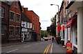
Residents of MK18 1AA have access to a range of nearby amenities, including five retail outlets such as Tesco Buckingham, Waitrose Buckingham, and M&S Buckingham BP. These shops provide practical shopping options for daily needs, from groceries to fuel. The presence of a nearby airport, Turweston Airport, adds to the area’s connectivity, offering travel opportunities for residents. While the data does not mention parks or leisure facilities, the proximity to Buckingham suggests that larger recreational spaces are available within a short distance. The compact nature of the area means that amenities are concentrated, making them easily accessible. The mix of retail and transport options supports a convenient lifestyle, though residents may need to venture slightly further for more extensive leisure or cultural activities.
Amenities
Schools
Residents of MK18 1AA have access to Buckingham County First School, a primary school serving the local community. The area is also near the University of Buckingham, which provides higher education opportunities. The presence of a primary school is a key consideration for families, offering a local option for younger children. However, the absence of secondary schools within the postcode means that students may need to travel to nearby towns for further education. The University of Buckingham adds to the area’s academic profile, potentially attracting students and academics to the surrounding region. For families, the mix of primary and higher education institutions suggests a balance between local and regional schooling options. The data does not include Ofsted ratings, so prospective buyers should investigate further to assess the quality of these educational institutions.
| Rank | School | Type | Entry gender | Ages |
|---|
Explore more schools in this area
Go to Schools tabDemographics
The population of MK18 1AA is predominantly composed of adults aged 30–64, with a median age of 47. This suggests a mature, settled community with a strong presence of middle-aged residents. Home ownership rates are relatively low at 33%, indicating that a significant portion of the population may be renting. The area is characterised by a high proportion of houses rather than flats or apartments, reflecting a traditional housing stock. The predominant ethnic group is White, which aligns with broader demographic trends in the region. With a population density of 1.8 million per square kilometre, the area is highly compact, which may influence social dynamics and access to shared spaces. The low home ownership rate could indicate a mix of rental properties and owner-occupied homes, but the data does not specify the balance between the two. This demographic profile suggests a community that is stable but may lack the diversity of younger or older age groups.
Household Size
Accommodation Type
Tenure
Ethnic Group
Religion
Household Composition
Age
Household Deprivation
NS-SEC
Explore more demographic insights in this area
Go to Demographics tabPlanning
Planning Constraints
- Flood RiskPremium
- Ramsar Wetland SitesPremium
- Area of Outstanding Natural BeautyPremium
- Protected Nature ReservePremium
- Protected WoodlandPremium