Area Overview for ME9 8EH
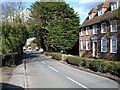
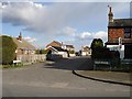
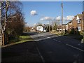
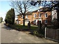
Photos of ME9 8EH


Area Information
ME9 8EH is a small, compact postcode area in England, spanning 18.6 hectares and home to 1,539 residents. Its population density of 67 people per square kilometre suggests a low-key, residential character, with a focus on private homes rather than high-density development. The area’s proximity to primary schools, railway stations, and local shops makes it practical for families and commuters. With a median age of 47, the community is predominantly composed of adults aged 30–64, reflecting a mature, stable demographic. This is not a sprawling suburb but a tightly knit cluster of properties, likely centred around a core of established housing. While the area lacks large-scale amenities, its small size means residents can access essential services within walking or short driving distance. The presence of multiple primary schools and rail links hints at a balance between convenience and quiet living. For buyers, ME9 8EH offers a snapshot of a traditional English village setting, with a focus on simplicity and proximity to key infrastructure.
- Area Type
- Postcode
- Area Size
- 18.6 hectares
- Population
- 1539
- Population Density
- 67 people/km²
ME9 8EH is a predominantly owner-occupied area, with 75% of homes owned by residents rather than rented. The accommodation type is exclusively houses, which is unusual for smaller postcode areas that often include flats or apartments. This suggests a focus on traditional, family-friendly housing stock, likely with gardens and more space than typical urban properties. The small size of the area—just 18.6 hectares—means the housing market is limited in scale, with few new developments likely. Buyers should consider the proximity to schools and transport as key selling points, as these are the primary attractions for families. However, the lack of rental properties indicates a market geared towards long-term residents rather than investors. The concentration of houses also means property values may be influenced by local amenities and the area’s designation within an Area of Outstanding Natural Beauty.
House Prices in ME9 8EH
Showing 39 properties
| Address | Type | Beds | Baths | Last Sale Price | Last Sale Date | |
|---|---|---|---|---|---|---|
| 2, Myrtle Cottages, Primrose Lane, South Of Motorway, Bredgar, ME9 8EH | Semi-detached | 3 | 1 | £345,000 | Mar 2025 | |
| Stonecroft, Primrose Lane, South Of Motorway, Bredgar, ME9 8EH | Detached | 3 | 2 | £700,000 | May 2023 | |
| 1, Myrtle Cottages, Primrose Lane, South Of Motorway, Bredgar, ME9 8EH | Detached | 3 | 1 | £375,000 | Feb 2023 | |
| Beaumont, Primrose Lane, South Of Motorway, Bredgar, ME9 8EH | Bungalow | - | - | £550,000 | Nov 2021 | |
| Ingleside, Primrose Lane, South Of Motorway, Bredgar, ME9 8EH | house | - | - | £442,000 | Apr 2021 | |
| Hollyleaf Cottage, Primrose Lane, South Of Motorway, Bredgar, ME9 8EH | Bungalow | 2 | 1 | £342,500 | Aug 2019 | |
| Medlar House, Primrose Lane, South Of Motorway, Bredgar, ME9 8EH | Detached | 4 | 1 | £550,000 | Mar 2019 | |
| Primrose Cottage, Primrose Lane, South Of Motorway, Bredgar, ME9 8EH | Detached | 5 | 4 | £760,000 | Mar 2018 | |
| Water Meadow, Primrose Lane, South Of Motorway, Bredgar, ME9 8EH | Detached | 4 | 1 | £527,000 | Nov 2017 | |
| Newnham Court Farm, Primrose Lane, South Of Motorway, Bredgar, ME9 8EH | Detached | 4 | - | £385,000 | Oct 2016 |
Energy Efficiency in ME9 8EH
The lifestyle in ME9 8EH is shaped by its proximity to retail and transport hubs. Within practical reach are shops such as Co-op Sittingbourne, Budgens MRH, and Tesco Milton, offering everyday essentials. The area’s rail links to Sittingbourne, Newington, and Kemsley provide access to broader shopping, dining, and leisure opportunities in nearby towns. While the data does not mention parks or recreational facilities, the presence of multiple primary schools suggests a community-oriented environment. The small size of the area means amenities are closely clustered, reducing the need for long journeys. For residents, this balance of local shops and transport links creates a convenient, low-maintenance lifestyle. However, the absence of detailed information on leisure or green spaces leaves room for speculation about the area’s character beyond basic needs.
Amenities
Schools
ME9 8EH is served by several primary schools, including Rodmersham School, which holds an Ofsted rating of outstanding. Other options include Milstead and Frinsted Church of England Primary School, which has a satisfactory rating, and Bredgar Church of England Primary School, though its rating is not specified. The presence of multiple primary schools within the area suggests a focus on education for younger children, with families likely prioritising proximity to schools when choosing homes. The mix of ratings indicates a range of quality, with Rodmersham standing out as a top-performing institution. However, the repetition of school names in the data may reflect proximity rather than distinct institutions. For parents, the availability of multiple primary schools reduces the need for long commutes, though secondary education options would require travel to nearby towns.
| Rank | School | Type | Entry gender | Ages |
|---|
Explore more schools in this area
Go to Schools tabDemographics
The population of ME9 8EH is 1,539, with a median age of 47, indicating a community skewed towards middle-aged adults. The most common age range is 30–64 years, suggesting a mix of working-age individuals and those nearing retirement. Home ownership is high at 75%, with accommodation primarily consisting of houses rather than flats or apartments. The predominant ethnic group is White, though specific data on diversity or deprivation is not provided. This demographic profile implies a stable, long-term resident base with fewer transient populations. The age distribution suggests a community with established careers and families, potentially with a focus on local schools and community ties. The lack of data on deprivation means it is unclear whether the area faces socioeconomic challenges, but the high home ownership rate and mature age profile generally correlate with lower deprivation levels.
Household Size
Accommodation Type
Tenure
Ethnic Group
Religion
Household Composition
Age
Household Deprivation
NS-SEC
Explore more demographic insights in this area
Go to Demographics tabPlanning
Planning Constraints
- Flood RiskPremium
- Ramsar Wetland SitesPremium
- Area of Outstanding Natural BeautyPremium
- Protected Nature ReservePremium
- Protected WoodlandPremium