Area Overview for ME8 7AS
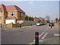
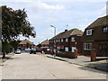
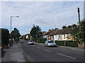
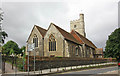
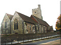
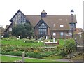
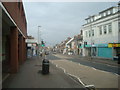
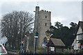
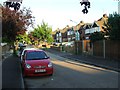
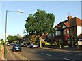
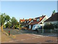
Photos of ME8 7AS

Area Information
Living in ME8 7AS offers a quiet, residential experience in a small cluster of homes. With a population of 1,780, the area feels intimate, shaped by a community of adults aged 30–64 years. The median age of 47 suggests a stable, established demographic, with 79% of residents owning their homes. This is a place where families and long-term residents coexist, with a focus on practical living rather than urban sprawl. The area’s proximity to rail networks and retail hubs like Tesco Rainham and Asda Rainham High ensures daily needs are met without venturing far. While ME8 7AS lacks the density of larger towns, its small-scale nature fosters a sense of familiarity. The broadband score of 99 and mobile coverage of 85 ensure reliable digital connectivity, supporting remote work or online activities. Safety is a key feature, with low flood risk and below-average crime rates. For those seeking a low-maintenance, family-friendly environment with access to essential services, ME8 7AS provides a straightforward, no-frills alternative to busier regions.
- Area Type
- Postcode
- Area Size
- Not available
- Population
- 1780
- Population Density
- 4378 people/km²
The property market in ME8 7AS is dominated by owner-occupied homes, with 79% of residents living in properties they own. This high rate of home ownership suggests a stable, long-term demographic with little reliance on rental markets. The accommodation type is primarily houses, which is unusual for areas with higher apartment or flat density. This indicates a suburban or semi-rural character, where larger homes are more common. For buyers, this means the available properties are likely to be family-sized houses rather than smaller units. The small population of 1,780 and the focus on houses suggest limited property turnover, making ME8 7AS a niche market for those seeking a specific type of housing. Proximity to rail stations like Rainham and Gillingham may appeal to commuters, but the area’s size means buyers must consider the broader regional context for larger property selections.
House Prices in ME8 7AS
No properties found in this postcode.
Energy Efficiency in ME8 7AS
Residents of ME8 7AS have access to essential retail outlets such as Tesco Rainham, Asda Rainham High, and Tesco Gillingham, ensuring everyday shopping needs are met. The area’s rail stations provide links to broader networks, facilitating travel to nearby towns like Gillingham and Rainham. While there are no named parks or leisure facilities in the data, the proximity to rail and retail suggests a functional lifestyle focused on practicality. The presence of Rochester Airport adds to the area’s accessibility for occasional travel. The lack of detailed information on leisure options means buyers should explore the surrounding regions for recreational opportunities. Overall, ME8 7AS offers a straightforward, service-oriented lifestyle with minimal local amenities but strong regional links.
Amenities
Schools
The nearest school to ME8 7AS is Medway Education Trust, though its specific type and Ofsted rating are not detailed in the data. This lack of granular information means families must investigate further to assess educational quality. The presence of a single named school suggests limited options within immediate reach, which could be a consideration for households with children. Families may need to travel beyond ME8 7AS to access a broader range of school types, such as primary or secondary institutions. The absence of data on school performance or diversity means potential buyers should conduct independent research to align educational needs with the area’s offerings.
| Rank | School | Type | Entry gender | Ages |
|---|
Explore more schools in this area
Go to Schools tabDemographics
ME8 7AS is predominantly inhabited by adults aged 30–64 years, reflecting a mature, stable population. The median age of 47 indicates a community with a strong presence of middle-aged residents, likely with established careers and families. Home ownership is high at 79%, suggesting a preference for long-term residency over rental properties. The accommodation type is primarily houses, which aligns with the area’s small, residential character. The predominant ethnic group is White, with no specific data on other demographics. This composition implies a homogeneous community with shared cultural and social norms. The absence of detailed diversity statistics means the area’s inclusivity remains unquantified, but the high home ownership and age profile suggest a focus on stability over transient populations. For buyers, this demographic profile may indicate a neighbourhood with low turnover and predictable community dynamics.
Household Size
Accommodation Type
Tenure
Ethnic Group
Religion
Household Composition
Age
Household Deprivation
NS-SEC
Explore more demographic insights in this area
Go to Demographics tabPlanning
Planning Constraints
- Flood RiskPremium
- Ramsar Wetland SitesPremium
- Area of Outstanding Natural BeautyPremium
- Protected Nature ReservePremium
- Protected WoodlandPremium