Area Overview for ME8 0RP
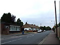
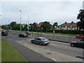
Photos of ME8 0RP


Area Information
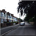
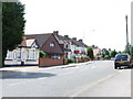
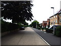
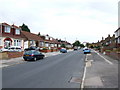
ME8 0RP is a compact residential postcode in England, covering just 1170 m² and home to 1505 people. Its high population density of 1481 people per km² reflects a tightly knit community, where daily life revolves around proximity to amenities and local infrastructure. This area is defined by its small-scale charm, with homes clustered closely and a focus on practical living. The presence of multiple railway stations within reach—Rainham, Gillingham, and Chatham—offers easy access to nearby towns and cities, while nearby shops like Tesco Gillingham and Iceland Twydall provide convenience for everyday needs. The area’s compact nature means residents are likely to know their neighbours, fostering a sense of familiarity. While it lacks sprawling green spaces or major landmarks, its strength lies in its accessibility and the balance between residential tranquility and connectivity to larger networks. For those seeking a self-contained, manageable living environment, ME8 0RP offers a straightforward, no-frills approach to housing.
- Area Type
- Postcode
- Area Size
- 1170 m²
- Population
- 1505
- Population Density
- 1481 people/km²
The property market in ME8 0RP is characterised by a strong emphasis on owner-occupation, with 88% of homes owned outright. This contrasts with areas where rental demand drives market dynamics, suggesting a stable, long-term resident base. The accommodation type is predominantly houses, which is notable given the area’s small size. This mix of high home ownership and house-based housing stock implies limited availability of flats or apartments, potentially restricting options for buyers seeking alternative property types. The compact nature of the postcode means the immediate surroundings are likely to mirror this pattern, with few new developments or varied housing styles. For buyers, this suggests a market focused on existing homes rather than speculative investment, with prices likely tied to the condition and size of individual properties. The high home ownership rate also indicates a degree of market resilience, as residents are less likely to move frequently.
House Prices in ME8 0RP
No properties found in this postcode.
Energy Efficiency in ME8 0RP
Daily life in ME8 0RP is shaped by its proximity to essential amenities. Within walking or short driving distance are retail options such as Aldi Twydall, Iceland Twydall, and Tesco Gillingham, offering a range of groceries and household goods. The area’s railway stations—Rainham, Gillingham, and Chatham—provide regular connections to nearby towns, while Rochester Airport offers additional travel flexibility. Though the area itself is small, the surrounding region likely includes parks, leisure facilities, and dining options not explicitly listed in the data. The compact layout ensures that residents can access these services without lengthy commutes, fostering a practical, convenience-driven lifestyle. The presence of multiple retail outlets and transport links suggests a community prioritising accessibility over sprawling suburban sprawl, making ME8 0RP suitable for those who value efficiency in daily routines.
Amenities
Schools
| Rank | School | Type | Entry gender | Ages |
|---|
Explore more schools in this area
Go to Schools tabDemographics
The community in ME8 0RP is predominantly composed of adults aged 30–64, with a median age of 47. This suggests a mature, stable population, likely with established careers and families. Home ownership is exceptionally high at 88%, indicating a strong preference for long-term residency over rental properties. The area is largely composed of houses rather than flats, which aligns with the demographic profile of older, family-oriented residents. The predominant ethnic group is White, though specific data on diversity or deprivation is not provided. The high population density of 1481 people per km² implies a tightly packed residential layout, which may influence the pace of life and availability of communal spaces. While no explicit data on deprivation is included, the high home ownership rate and age profile suggest a relatively secure economic environment, though the compact size of the area may limit opportunities for expansion or new development.
Household Size
Accommodation Type
Tenure
Ethnic Group
Religion
Household Composition
Age
Household Deprivation
NS-SEC
Explore more demographic insights in this area
Go to Demographics tabPlanning
Planning Constraints
- Flood RiskPremium
- Ramsar Wetland SitesPremium
- Area of Outstanding Natural BeautyPremium
- Protected Nature ReservePremium
- Protected WoodlandPremium