Area Overview for ME7 4AJ
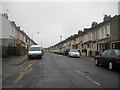
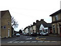
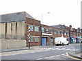
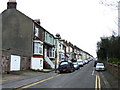
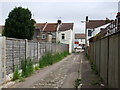
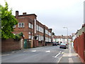
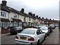
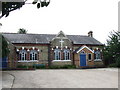
Photos of ME7 4AJ


Area Information
ME7 4AJ is a small residential cluster in England, home to 1,486 residents. This compact area blends practicality with accessibility, offering a mix of local amenities and transport links. The community is characterised by a mature demographic, with a median age of 47 and a majority of residents aged 30–64. Daily life here is shaped by proximity to retail hubs like Co-op Canterbury and Morrisons Daily, alongside rail stations at Gillingham and Rochester, which provide easy access to broader networks. The area’s digital connectivity is near flawless, with a broadband score of 100, ensuring seamless internet use for work or leisure. While the population is small, the presence of multiple shops, rail options, and Rochester Airport within reach suggests a balance between suburban tranquillity and urban convenience. For those seeking a self-contained yet connected lifestyle, ME7 4AJ offers a distinct blend of local identity and practical infrastructure.
- Area Type
- Postcode
- Area Size
- Not available
- Population
- 1486
- Population Density
- 6152 people/km²
ME7 4AJ is primarily an owner-occupied area, with 72% of homes owned by residents rather than rented. The accommodation type is predominantly houses, which is unusual for smaller postcode areas and suggests a focus on single-family dwellings. This housing stock may appeal to buyers seeking traditional properties with more space and garden potential. However, the small population and limited number of homes mean the market is likely constrained, with limited scope for new developments or rental properties. Buyers should consider the area’s size and proximity to larger towns like Rochester, where additional housing options may be available. For those prioritising homeownership in a low-density setting, ME7 4AJ offers a niche opportunity, though its small scale may limit long-term appreciation or investment potential.
House Prices in ME7 4AJ
No properties found in this postcode.
Energy Efficiency in ME7 4AJ
Living in ME7 4AJ offers access to a range of local amenities, including five retail outlets such as Co-op Canterbury, Tesco Gillingham, and Morrisons Daily. These shops provide everyday essentials, reducing the need for long trips to larger towns. The area’s rail network is well-served by stations at Gillingham, Chatham, and Rochester, enabling easy commuting to nearby cities or for leisure travel. Rochester Airport is within reach, adding convenience for occasional air travel. While the area lacks large parks or entertainment venues, the presence of multiple retail and transport hubs suggests a functional lifestyle focused on accessibility. Residents can enjoy a mix of local shopping, reliable transport, and proximity to regional airports, though cultural or recreational amenities may require venturing further afield.
Amenities
Schools
| Rank | School | Type | Entry gender | Ages |
|---|
Explore more schools in this area
Go to Schools tabDemographics
The community in ME7 4AJ is predominantly composed of adults aged 30–64, with a median age of 47. This suggests a stable population of middle-aged residents, likely focused on long-term living rather than transient stays. Home ownership is high, at 72%, indicating a strong presence of owner-occupied properties. The area is largely composed of houses, reflecting a traditional housing stock rather than flats or apartments. The predominant ethnic group is White, though no specific data on diversity or deprivation is provided. The age profile and ownership rates imply a community prioritising stability and family-oriented living, with fewer young families or elderly residents compared to other areas. This demographic profile may influence local services and amenities, tailored to the needs of working-age adults and retirees.
Household Size
Accommodation Type
Tenure
Ethnic Group
Religion
Household Composition
Age
Household Deprivation
NS-SEC
Explore more demographic insights in this area
Go to Demographics tabPlanning
Planning Constraints
- Flood RiskPremium
- Ramsar Wetland SitesPremium
- Area of Outstanding Natural BeautyPremium
- Protected Nature ReservePremium
- Protected WoodlandPremium