Area Overview for ME5 7AX
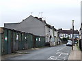
Photos of ME5 7AX


Area Information
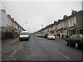
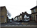
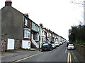
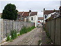
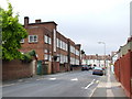
ME5 7AX is a small, tightly knit residential cluster in England, home to 1,719 residents. The area’s compact size fosters a quiet, community-oriented lifestyle, with homes predominantly in private ownership. With a median age of 47 and a strong presence of adults aged 30–64, the population reflects a mature, stable demographic. Daily life here is shaped by proximity to essential services, including five retail outlets such as Morrisons Daily and Co-op Canterbury, and easy access to rail networks like Gillingham and Rochester stations. The area’s broadband score of 100 ensures seamless digital connectivity, supporting remote work and online activities. While the postcode lacks traditional schools, it is near Rochester Airport, offering travel convenience. ME5 7AX balances suburban tranquillity with practical amenities, making it suitable for those prioritising security, connectivity, and a low-flood-risk environment. However, the high crime risk score of 6 necessitates caution, particularly for families.
- Area Type
- Postcode
- Area Size
- Not available
- Population
- 1719
- Population Density
- 6739 people/km²
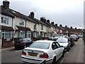
ME5 7AX is a small area with a housing stock dominated by private homes, reflecting the 55% home ownership rate. The lack of high-rise or apartment blocks means properties are likely to be semi-detached or terraced, typical of smaller residential clusters. With only 1,719 residents, the market is limited in scale, which could mean fewer options for buyers but potentially more characterful properties. The area’s proximity to rail networks like Gillingham and Rochester stations may appeal to commuters, though the small size of the postcode means buyers should consider nearby areas for broader choices. The predominance of owner-occupied homes suggests a stable market, but the high crime risk score of 6 could influence property values and desirability.
House Prices in ME5 7AX
No properties found in this postcode.
Energy Efficiency in ME5 7AX
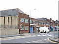
Daily life in ME5 7AX is shaped by its proximity to retail and transport hubs. Five retail outlets, including Morrisons Daily and Co-op Canterbury, provide essential shopping options within walking or short driving distance. The area’s rail connections to Gillingham, Chatham, and Rochester stations make commuting to nearby towns straightforward, while Rochester Airport offers travel convenience. The compact size of the postcode means amenities are concentrated, fostering a sense of accessibility. However, the absence of parks, leisure facilities, or dining venues in the data suggests residents may need to venture further for recreational activities. The area’s character is defined by its practicality, with services prioritising functionality over luxury.
Amenities
Schools
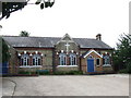
The only named educational institution near ME5 7AX is the Hospital and Medical Tuition Service, categorised as "other." No primary or secondary schools are listed in the data, which may require families to seek options further afield. The absence of traditional schools in the immediate vicinity could be a limitation for households prioritising local education. Residents may need to rely on nearby towns or consider the proximity to Rochester Airport for travel to larger educational hubs. The lack of school data highlights the need for further research into local educational provision, though the area’s small size may mean schools are concentrated in adjacent postcodes.
| Rank | School | Type | Entry gender | Ages |
|---|
Explore more schools in this area
Go to Schools tabDemographics
The community in ME5 7AX is predominantly composed of adults aged 30–64, with a median age of 47. This suggests a population that is largely established, with fewer young families or retirees. Home ownership stands at 55%, indicating a mix of owner-occupied properties and rental homes. The accommodation type is primarily houses, which aligns with the area’s small, residential character. The predominant ethnic group is White, though no specific data on diversity or deprivation levels is provided. The population size of 1,719 means the area is small enough to feel close-knit but large enough to support basic amenities. The absence of detailed deprivation data limits insight into socioeconomic challenges, but the high home ownership rate and mature age profile suggest a relatively stable community.
Household Size
Accommodation Type
Tenure
Ethnic Group
Religion
Household Composition
Age
Household Deprivation
NS-SEC
Explore more demographic insights in this area
Go to Demographics tabPlanning
Planning Constraints
- Flood RiskPremium
- Ramsar Wetland SitesPremium
- Area of Outstanding Natural BeautyPremium
- Protected Nature ReservePremium
- Protected WoodlandPremium