Area Overview for ME2 3DW
Photos of ME2 3DW

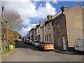
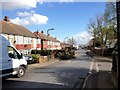
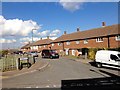
60 photos from this area
Area Information
Key information about the ME2 3DW including its size, population, and administrative classification.
- Area Type
- Postcode
- Area Size
- 6549 m²
- Population
- 1524
- Population Density
- 7366 people/km²
House Prices in ME2 3DW
22
Properties
£193,083
Average Sold Price
£52,500
Lowest Price
£300,000
Highest Price
Showing 22 properties
| Address | Type | Beds | Baths | Last Sale Price | Last Sale Date | |
|---|---|---|---|---|---|---|
| 153 Cliffe Road, Strood, Rochester, ME2 3DW | Terraced | 3 | 1 | £270,000 | Jun 2023 | |
| 167 Cliffe Road, Strood, Rochester, ME2 3DW | Terraced | 3 | 1 | £285,000 | Dec 2022 | |
| 143 Cliffe Road, Strood, Rochester, ME2 3DW | house | - | - | £300,000 | Apr 2022 | |
| 169 Cliffe Road, Strood, Rochester, ME2 3DW | house | - | - | £247,500 | Nov 2018 | |
| 173 Cliffe Road, Strood, Rochester, ME2 3DW | Terraced | 3 | 1 | £227,000 | Jun 2016 | |
| 145 Cliffe Road, Strood, Rochester, ME2 3DW | Semi-detached | 4 | 1 | £235,000 | May 2014 | |
| 171 Cliffe Road, Strood, Rochester, ME2 3DW | Terraced | 3 | 1 | £141,000 | May 2012 | |
| 177 Cliffe Road, Strood, Rochester, ME2 3DW | house | - | - | £206,500 | Jun 2009 | |
| 149 Cliffe Road, Strood, Rochester, ME2 3DW | Terraced | - | - | £118,000 | Jul 2005 | |
| 179 Cliffe Road, Strood, Rochester, ME2 3DW | Terraced | - | - | £157,500 | Dec 2002 |
Page 1 of 3
Energy Efficiency in ME2 3DW
Amenities
Schools
| Rank | School | Type | Entry gender | Ages |
|---|
Explore more schools in this area
Go to Schools tabDemographics
Household Size
One person
most common
Accommodation Type
Houses
most common
Tenure
46
majority
Ethnic Group
White
most common
Religion
N/A
most common
Household Composition
N/A
most common
Age
47
median
Adults (30-64 years)
most common
Household Deprivation
N/A
with no deprivation
NS-SEC
25
in Lower managerial occupations
Explore more demographic insights in this area
Go to Demographics tabPlanning
Planning Constraints
- Flood RiskPremium
- Ramsar Wetland SitesPremium
- Area of Outstanding Natural BeautyPremium
- Protected Nature ReservePremium
- Protected WoodlandPremium