Area Overview for ME2 2ST
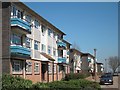
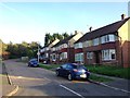
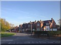
Photos of ME2 2ST


Area Information
Living in ME2 2ST means being part of a small, tightly knit residential cluster in England, home to 1,664 residents. This postcode area is defined by its compact size and proximity to essential services, making it practical for those prioritising convenience. The community here is largely composed of adults aged 30–64, reflecting a mature demographic with established roots. Daily life is shaped by the area’s accessibility to schools, transport links, and retail hubs. While the population is modest, the presence of multiple primary schools and rail stations underscores its appeal for families and commuters. The area’s character is grounded in its residential focus, with a mix of homes that cater to local needs. For those seeking a balance between suburban calm and urban connectivity, ME2 2ST offers a microcosm of practical living, with amenities within easy reach. Its small scale means a strong sense of community, though it remains a niche postcode with limited expansion potential.
- Area Type
- Postcode
- Area Size
- Not available
- Population
- 1664
- Population Density
- 3646 people/km²
The property market in ME2 2ST is characterised by a high rate of home ownership (64%) and a predominance of houses over flats or apartments. This suggests a residential area tailored to families and individuals seeking more space, rather than a rental market. The small scale of the postcode means the housing stock is limited, with no indication of recent developments or new builds. For buyers, this implies a competitive market with limited options, particularly for those seeking properties in the immediate vicinity. The focus on owner-occupation also indicates that residents are likely to have long-term plans for their homes, reducing turnover. However, the lack of diversity in accommodation types may limit appeal for those requiring smaller units or modernised properties. Proximity to schools, rail links, and retail amenities enhances the area’s desirability, though buyers should consider the potential challenges of a constrained housing supply in a small postcode.
House Prices in ME2 2ST
No properties found in this postcode.
Energy Efficiency in ME2 2ST
Residents of ME2 2ST have access to a practical array of amenities, including five retail outlets such as Morrisons Daily, Asda Strood, and Tesco Strood, ensuring daily shopping needs are met. The area’s rail network, with stations like Cuxton and Strood, connects to broader transport hubs, while nearby ferry terminals provide links to surrounding regions. Rochester Airport offers additional travel flexibility. Though the area is small, its proximity to these services enhances convenience. The presence of multiple retail options and transport links contributes to a lifestyle that balances local self-sufficiency with regional connectivity. The mix of shops, transport, and travel options ensures residents can manage both routine tasks and occasional trips with ease, supporting a practical, accessible daily life.
Amenities
Schools
Residents of ME2 2ST have access to a range of primary schools, including Bligh Junior School, Bligh Infant School, Chapter School, and Rede School. These institutions provide early education options for young families, with a focus on primary-level learning. Strood Academy, an academy with a ‘good’ Ofsted rating, offers secondary education nearby. The mix of school types ensures coverage from early years through to secondary schooling, reducing the need for long commutes. The presence of multiple primary schools also allows for choice, which is crucial for parents prioritising educational quality. While no secondary schools are listed in the immediate area, Strood Academy’s rating suggests it meets acceptable standards. This combination of local primaries and a rated secondary school makes ME2 2ST a viable option for families seeking a balanced educational environment.
| Rank | School | Type | Entry gender | Ages |
|---|
Explore more schools in this area
Go to Schools tabDemographics
The population of ME2 2ST is 1,664, with a median age of 47. This suggests a community skewed towards middle-aged adults, with the most common age range being 30–64 years. Home ownership is high at 64%, indicating a stable, long-term resident base. The predominant accommodation type is houses, reflecting a traditional, family-oriented housing stock. The predominant ethnic group is White, which aligns with broader regional trends. This demographic profile suggests a settled, low-turnover area where residents are likely to have established careers and family ties. The absence of specific deprivation data means quality of life is inferred from the availability of services and infrastructure. With no mention of social housing or rental properties, the area appears to cater more to owner-occupiers than renters. The age distribution implies a community with a strong focus on stability, though it may lack the vibrancy of younger, more transient populations.
Household Size
Accommodation Type
Tenure
Ethnic Group
Religion
Household Composition
Age
Household Deprivation
NS-SEC
Explore more demographic insights in this area
Go to Demographics tabPlanning
Planning Constraints
- Flood RiskPremium
- Ramsar Wetland SitesPremium
- Area of Outstanding Natural BeautyPremium
- Protected Nature ReservePremium
- Protected WoodlandPremium