Area Overview for ME2 2JE
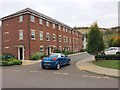
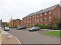
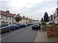
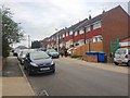
Photos of ME2 2JE


Area Information
Living in ME2 2JE offers a compact, residential experience with a population of 2,419 residents. This small postcode area is defined by its cluster of homes, predominantly owner-occupied properties, and a community skewed towards adults aged 30–64. The area’s character is shaped by its proximity to key amenities, including five retail outlets like Morrisons Daily and Tesco Strood, and multiple rail stations such as Strood and Rochester. Daily life here balances local convenience with broader connectivity, with Rochester Airport within reach. The demographic profile suggests a stable, mature population, with no significant environmental constraints like protected woodlands or flood zones. For buyers, ME2 2JE presents a straightforward choice: a low-crime, low-risk area with practical infrastructure, though its small size means limited housing stock. The presence of three schools, including a primary academy rated ‘good’ by Ofsted, adds to its appeal for families. This is a place where simplicity and accessibility meet, ideal for those prioritising safety and ease of access over sprawling urban or rural landscapes.
- Area Type
- Postcode
- Area Size
- Not available
- Population
- 2419
- Population Density
- 3154 people/km²
The property market in ME2 2JE is dominated by owner-occupied homes, with 75% of residents owning their properties. This suggests a stable, low-turnover market where housing is primarily for long-term residence rather than investment or rental. The area’s accommodation is almost entirely houses, which may appeal to buyers seeking family-friendly layouts or those prioritising space over density. Given the postcode’s small size, the housing stock is likely limited, meaning buyers should consider the immediate surrounding areas for more options. The absence of flats or commercial properties indicates a focus on residential living without the complexities of mixed-use developments. For those seeking a quiet, low-risk environment with established homes, ME2 2JE offers a straightforward proposition, though its compact nature may restrict choice for those needing specific property types or larger spaces.
House Prices in ME2 2JE
Showing 2 properties
| Address | Type | Beds | Baths | Last Sale Price | Last Sale Date | |
|---|---|---|---|---|---|---|
| Former Tesco Distribution Centre, Knight Road, Strood, Rochester, ME2 2JE | general_industrial | - | - | - | - | |
| Former Tesco Regional Personnel Office, Former Tesco Distribution Centre, Knight Road, Strood, Rochester, ME2 2JE | Office | - | - | - | - |
Energy Efficiency in ME2 2JE
The lifestyle in ME2 2JE is shaped by its proximity to five retail outlets, including Morrisons Daily and Tesco Strood, ensuring everyday shopping needs are met locally. The rail network, with stations like Strood and Rochester, provides easy access to nearby towns and cities, while Rochester Airport offers regional and international travel options. Though the data does not mention parks or leisure facilities, the absence of environmental constraints like protected woodlands or AONBs suggests open spaces may be available nearby. The area’s practical amenities—combining retail, transport, and connectivity—create a convenient, low-stress environment. Residents can enjoy a balance of local convenience and broader access, making it ideal for those who value accessibility without the hustle of larger urban centres.
Amenities
Schools
ME2 2JE is served by three schools, including two primary schools—Sherwin Knight Junior School and Cedar Primary School—and Cedar Children’s Academy, a primary academy rated ‘good’ by Ofsted. The presence of both traditional primary schools and an academy provides families with options, though no secondary schools are listed in the data. The ‘good’ rating at Cedar Children’s Academy suggests a reliable educational standard, while the other schools, though not rated, are likely to meet baseline expectations. The mix of school types may cater to different preferences, such as smaller class sizes at primary schools or structured curricula at academies. For families prioritising education, the proximity of these schools reduces commuting time, enhancing the area’s appeal. However, the absence of secondary schools means buyers should check the catchment areas of nearby postcodes for comprehensive schooling.
| Rank | School | Type | Entry gender | Ages |
|---|
Explore more schools in this area
Go to Schools tabDemographics
ME2 2JE’s population is predominantly adults aged 30–64, with a median age of 47. This suggests a mature, settled community, likely with strong ties to local institutions and a focus on stability. Home ownership is high at 75%, indicating a preference for long-term residency over rental properties. The area is characterised by houses rather than flats, aligning with the demographic’s likely family-oriented needs. The predominant ethnic group is White, though no further breakdown of diversity is provided. The absence of specific data on deprivation means the quality of life cannot be assessed in that context, but the low crime score of 68 (described as low risk) and no environmental constraints suggest a generally secure, untroubled living environment. The demographic profile implies a community that values continuity, with a focus on established housing and local amenities rather than transient or high-turnover populations.
Household Size
Accommodation Type
Tenure
Ethnic Group
Religion
Household Composition
Age
Household Deprivation
NS-SEC
Explore more demographic insights in this area
Go to Demographics tabPlanning
Planning Constraints
- Flood RiskPremium
- Ramsar Wetland SitesPremium
- Area of Outstanding Natural BeautyPremium
- Protected Nature ReservePremium
- Protected WoodlandPremium