Area Overview for ME2 1BL
Photos of ME2 1BL


Area Information
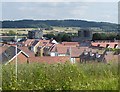
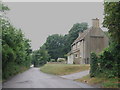
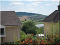
ME2 1BL is a small, tightly knit residential area in England, home to 1,533 people spread across a compact cluster of homes. With a population density of 777 people per square kilometre, it’s a place where community ties are likely strong, and daily life is shaped by proximity to local amenities. The area’s demographics suggest a mature, stable population, with a median age of 47 and most residents falling within the 30-64 age range. This hints at a community of long-term residents, many of whom are likely homeowners, given that 85% of properties are owner-occupied. The area is dominated by houses rather than flats, offering a traditional, family-friendly living environment. Nearby, Cuxton Community Infant and Junior Schools provide education for local children, while nearby rail stations and retail hubs like Tesco Halling and Co-op Cuxton ensure everyday needs are met. ME2 1BL is a quiet, practical choice for those seeking a low-maintenance, close-knit neighbourhood with access to essential services.
- Area Type
- Postcode
- Area Size
- Not available
- Population
- 1533
- Population Density
- 777 people/km²
ME2 1BL is primarily an owner-occupied area, with 85% of properties in private hands. The housing stock is dominated by houses rather than flats, which is unusual for a small postcode area but suggests a focus on family-friendly, spacious homes. This composition likely reflects the area’s appeal to established residents, particularly those in the 30-64 age range who prefer the privacy and space of a house. The limited number of properties means the market is likely tight, with fewer opportunities for new buyers compared to larger urban areas. For those seeking a home, ME2 1BL offers a chance to enter a stable market with long-term residents, though the small size of the area means competition could be fierce. The lack of rental properties also means buyers may find fewer options for investment or short-term stays.
House Prices in ME2 1BL
No properties found in this postcode.
Energy Efficiency in ME2 1BL
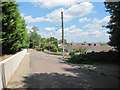
Daily life in ME2 1BL is supported by a range of nearby amenities, from retail to transport. The area has five retail outlets, including Tesco Halling and Co-op Cuxton, providing essential shopping options. Rail stations like Halling and Cuxton offer easy access to wider destinations, while Rochester Airport caters to those needing air travel. Though the area is small, these amenities suggest a practical, self-contained lifestyle. The presence of multiple shops and transport links means residents can meet daily needs without venturing far. The character of the area is likely defined by its quiet, residential nature, with a focus on convenience over sprawling commercial spaces. For those valuing ease of access to essentials, ME2 1BL offers a balance of local services and regional connectivity.
Amenities
Schools
The area is served by two primary schools: Cuxton Community Infant School and Cuxton Community Junior School, both of which are academies. One of these, Cuxton Community Junior School, holds a good Ofsted rating, indicating a reliable standard of education. The presence of both community-run and academy schools offers families a choice between traditional and more independently managed institutions. For parents, this mix may provide flexibility, whether they prefer the structure of a community school or the resources of an academy. The schools are likely central to daily life in ME2 1BL, with many residents relying on them for childcare and community engagement. The good rating at one school suggests that at least part of the education system meets or exceeds regional benchmarks, which is a key consideration for families prioritising quality schooling.
| Rank | School | Type | Entry gender | Ages |
|---|
Explore more schools in this area
Go to Schools tabDemographics
The population of ME2 1BL is predominantly adults aged 30-64, with a median age of 47, reflecting a mature, established community. Home ownership is high at 85%, indicating a stable housing market with few renters. The area is largely composed of houses, suggesting a preference for traditional, private living spaces over flats. The predominant ethnic group is White, though no specific diversity statistics are provided. This age profile implies a population focused on long-term residency, likely with families and professionals seeking a settled environment. The absence of data on deprivation or income levels means the quality of life can only be inferred from the availability of amenities and safety metrics. The area’s demographic makeup suggests a community that values stability, with limited turnover and a focus on local connections.
Household Size
Accommodation Type
Tenure
Ethnic Group
Religion
Household Composition
Age
Household Deprivation
NS-SEC
Explore more demographic insights in this area
Go to Demographics tabPlanning
Planning Constraints
- Flood RiskPremium
- Ramsar Wetland SitesPremium
- Area of Outstanding Natural BeautyPremium
- Protected Nature ReservePremium
- Protected WoodlandPremium